

Collection: Smith Collection
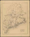
Name: Rail Road Map of Maine
Barcode:
Image Number:
Creator:
From Atlas:
Publishing Location:
Notes: Appears in Stuart's Atlas of the State of Maine. 1st Revised Edition, 1890-1. Verso: Plan of Cape Arundel Kennebunkport Kennebunk Beach and Cape Porpoise. Upper right corner: "19"
Atlas Reference:
Subjects:
Publisher:
Date/Date Range Produced:
Date/Date Range Published:
Language:
Region Depicted:
Map Type:
Dimensions: 39 x 3 cm
Material Type:
Brief Description:
Physical Description:
OCLC: 47709537
Accession Number: SM-1891-39
See Also:
Donor:
Permanent URL: