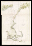
U.S. Coast Survey, A. D. Bache. Superintendent, Sketch A, shewing the progress of the survey in Section no. 1, from 1844 to 1853
Collection:
Gibb Collection
Name: U.S. Coast Survey, A. D. Bache. Superintendent, Sketch A, shewing the progress of the survey in Section no. 1, from 1844 to 1853
Barcode: 47085
Image Number: 47085.0001
Alternative Title: Sub-sketch Showing the position of Davis Shoal, Discovered by the U.S. Coast Survey in 1846
Physical Description: Chart No. 1
Chart of New England coast from Cape Cod to Musgongus Bay (Maine)
Publishing Location: Washington D.C.
Date/Date Range Produced: 1853
Date/Date Range Published: 1853
Accession Number: GIB-1853-35
Donor: Gibb
Permanent URL:
https://oshermaps.org/map/47085.0001