

Collection: Osher Map Library Collection
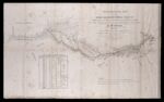
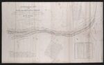
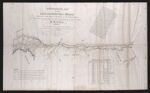
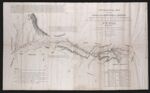
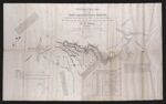
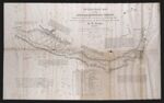
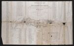
Name: Topographical map of the road from Missouri to Oregon, commencing at the mouth of the Kansas in the Missouri River and ending at the mouth of the Wallah Wallah in the Columbia.
Barcode:
Image Number:
Creator:
Publishing Location:
Notes: Gift of Ethel Bean Turner 9/14/2015
Date/Date Range Produced:
Date/Date Range Published:
Language:
Dimensions: 41 x 66
Physical Description: In seven sections: from the field notes and journal of Capt. J.C.Fremont and from sketches and notes made on the ground by his assistant Charles Preuss.
LC Call Number: G4501.S12 1846.F742
OCLC: 36480667
Accession Number: OML-1846-55
Permanent URL: