

Collection: Osher Map Library Collection
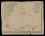
Name: Map showing positions of war vessels of the United States and Spain and the battle ground in case of hostilities
Barcode:
Image Number:
Publisher:
Publishing Location:
Language:
Map Type:
Dimensions: 24 x 31 cm
Brief Description: Spanish-American War conflict between the United States and Spain over the independence of Cuba from Spain.
LC Call Number: E714 1898.W3
OCLC: 1050339130
Accession Number: OML-1898-96
Permanent URL: