

Collection: Hamilton-Thayer Collection
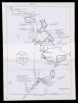
Name: The Chadwick Map of 1764 from the original in the colonial office, London reduced to about one-fourth
Barcode:
Image Number:
Surveyor:
Publishing Location:
Date/Date Range Produced: 1764 - 1926
Language:
Dimensions: 48 x 35 cm
Brief Description: Joseph Chadwick was employed by Massachusetts to make a survey from Fort Pownall to Quebec for a highway to Canada on the Penobscot River.
LC Call Number: G3732.P4 1926 C4
OCLC: 1107669100
Accession Number: HT-1926-174
Donor:
Permanent URL: