

Collection: Osher Map Library Collection
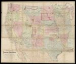
Name: National map of the territory of the United States from the Mississippi River to the Pacific Ocean
Barcode:
Image Number:
Creator:
Publishing Location:
Notes: "Entered according to Act of Congress in the year 1867 by Wm. J. Keeler in the Clerks Office of the District Court of the District of Columbia."
Date/Date Range Produced:
Date/Date Range Published:
Language:
Map Type:
Dimensions: 120 x 145 cm folded to 26 x 32 cm in slipcase
Brief Description: Map relates to the beginnings of the American Indian reservation system through the late 1860's. Very likely it was the official document used by the Indian Bureau and William Keeler to document and update the locations of the reservations and also the mineral deposits. Manuscript annotations indicate reservation boundaries outlined in different colors. Each is labeled with relevant treaty dates or proclamation of the reservation. Included is a colored map key or "explanation" indicating the locations of gold, silver, copper, quicksilver, iron and coal. The reservations were located away from the mineral deposits. Map also shows railroads, forts, military posts and proposed railway track.
LC Call Number: G3700 1867.K4
OCLC: 1102681500
Accession Number: OML-1867-50
Permanent URL: