

Collection: Osher Map Library Collection
Name: Dated events World War map
Barcode:
Image Number:
Creator:
Publisher:
Date/Date Range Produced:
Date/Date Range Published:
Dimensions: 49 x 66 cm
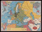
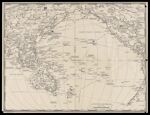
Notes: "This map illustrates the important events since the War began September 3, 1939." Shows Second World War military actions, naval bases, cities blitzed by the Nazis Luftwaffe, industries and harbours repeatedly bombed by the R.A.F. Inset maps: Africa -- Western Hemisphere -- Part of the Eastern Hemisphere. Verso: Untitled map of the Pacific. Last "Dated Event" is for May 5-7, 1942.
Accession Number: OML-1942-204
Donor:
Subjects:
Permanent URL: