

Collection: Osher Map Library Collection
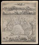
Name: Ignographia Candiae tertia vice a turcis obessae in lucem edita a F. de Wit
Barcode:
Image Number:
Creator:
Publishing Location:
Date/Date Range Produced: 1660 - 1668
Language:
Map Type:
Dimensions: 57 x 50 cm
Physical Description: Map shows the siege of the city of Heraklion by the Ottomans from 1648 to 1669. The ships of the Knights of Malta can be seen fighting in the background. The Ottomans eventually conquered the Venetian controlled city, Heraklion or Erakleion is the largest city and administrative capital of the Island of Crete.
LC Call Number: G6814.E7 1668 W5
OCLC: 1114265768
Accession Number: OML-1668-4
Permanent URL: