


Collection: Osher Map Library Collection
Name: The World on Gales projection
Barcode:
Image Number:
Creator:
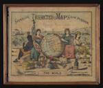
Alternative Title: Superior Dissected Maps
Publishing Location:
Notes: Wooden jig-saw puzzle depicting the world. Lid cover is illustrated with colorful female figures representing four continents: Africa, America, Europe and Asia. Illustrations include tokens of civilization such as the arts, knowledge through books, scientific instruments, and a cornucopia representing abundance. Title from puzzle.
Date/Date Range Published: 1880
Region Depicted:
Material Type:
LC Call Number: G3200 1880.P4
OCLC: 1117469793
Accession Number: OML-1880-75
Permanent URL: