

Collection: Osher Map Library Collection
Name: Map Seventh Division railway mail service
Barcode:
Image Number:
Publisher:
Date/Date Range Produced:
Date/Date Range Published:
Dimensions: 60 x 101 cm
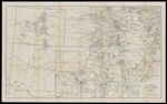
Notes: Part of the International Correspondence Schools reference library maps set Map showing railway mail service lines in the Western states (principally Missouri, Arkansas, Kansas, Oklahoma, Colorado, and New Mexico) in the early 20th century. Inset: Vicinity of Kansas City, Mo. enlarged scale
OCLC: 918864526
Accession Number: OML-1909-136
Permanent URL: