

Collection: Osher Map Library Collection
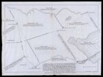
Name: [Boundary survey of Gorhamtown, Piersontown, and Naragansett No. 1, showing the Saco and Presumpscot Rivers, along with parts of Biddeford, Scarborough, and Falmouth]
Barcode:
Image Number:
Creator:
Date/Date Range Produced:
Date/Date Range Published:
Dimensions: 57 x 77 cm
Notes: "This plan contains the true depiction of Piersontown, Naragansett No. 1, and No. 7 or Gorhamtown with the headlines of Falmouth, Scarborough and Biddeford next No. 1 and No. 7 together with the lines between Falmouth & Scarborough, and between Scarborough & Biddeford agreeable to my minutes thereof as surveyed by Order of the General Court, Sept. 1762 and a plan thereof returned on Jan. 1763; since lost or mislaid; now therefore agreeable to a Resolve of the Great and General Court of the Province I return this as a true plan of the several Towns and Lines thereon mentioned and am sensible of no mistake therein. Newberry, June 1767. Capt. John Small survey. Capt. John Brown Esq. made oath to the truth of the above Return by him subscribed." Bottom right: "Traced by G.G. June 14, '07." "Saco River surveyed April 16, 1761 by John Brown, Jeremiah Hill & Enoch Bartlett." "Presumpscot River partly from Mr. Joseph Noyes' & partly from Capt. Small's survey."
Accession Number: OML-1907-113
Permanent URL: