

Collection: Osher Map Library Collection
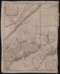
Name: Map of the District of Maine Drawn from the Latest Surveys and Other Best Authorities of Osgood Carleton
Barcode:
Image Number:
Creator:
From Atlas:
Publishing Location:
Notes: Removed from "History of the District of Maine" [Barcode: 14991] Note lower right: "A Map of those parts of the Country most famous for being harrased by the Indians, on and long after their first settlement; and more particularly treated of in Judge Sullivan's History of the District of Maine" Note at top: "Engraved for Judge Sullivan's History of the District of Maine, published by Thomas & Andrews, Boston 1795." Includes bibliographical references to land grants.
Publisher:
Date/Date Range Produced:
Date/Date Range Published:
Language:
Region Depicted:
Map Type:
Dimensions: H 55 x W 44 cm
Brief Description:
Physical Description:
LC Call Number: G3730 1795 .C3
OCLC: 6610133
Accession Number: OML-1795-26.2
Subjects:
Permanent URL: