

Collection: Osher Map Library Collection
Name: Ornamental Map of the United States & Mexico
Barcode:
Image Number:
From Atlas:
Publishing Location:
Publisher:
Date/Date Range Published: 1848
Language:
Region Depicted:
Map Type:
Dimensions: 35 x 37 cm on sheet 74 x 54 cm
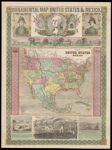
Brief Description: Above map: Portraits of Gen. Taylor, Washington, and Gen. Scott, and illustrated vignettes titled: "Panoramic view from New York to the Pacific Ocean by the contemplated Oregon railroad" ; "Great Temple dedicated to the Sun," ; "An American exhibiting to the sovereins of Europe the progress of his country," and "The Halls of the Montezumas." Includes texts for the "Great temple" and "Halls of the Montezumas" vignettes and brief statistics for Maine, New Hampshire, Vermont, Massachusetts, Rhode Island, Connecticut, New York, New Jersey, Pennsylvania, Delaware, Maryland, Virginia, North Carolina, South Carolina, Georgia, Florida, California, Oregon, Iowa, Wisconsin, Michigan, Missouri, Illinois, Indiana, Ohio, Kentucky, Tennessee, Arkansas, Texas, Louisiana, Mississippi, Alabama; map, text and illustrations within ornamental border of green pentacles (three of which are inverted). The map is the earliest printed map to show Minnesota Territory called "Minesota". It became a territory on March 3, 1849.
Historical Context: Mexican War fought from April, 1846 to February, 1848 between the United States and Mexico over the annexation of the Republic of Texas by the United States in 1845. The dispute centered on whether Texas ended at the Nueces River - the Mexican claim - or the Rio Grande - the United States claim.
LC Call Number: G3700 1848.E5
OCLC: 1048615512
Accession Number: OML-1848-46
Permanent URL: