State of the British and French Colonies in North America, With Respect to Number of People, Forces, Forts, Indians, Trade and other Advantages...
Collection:
Osher Collection
Page Name:
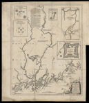
A Plan of Kennebek & Sagadahok Rivers, with the adjacent Coasts: taken from Actual Surveys, and dedicated to his Excely. William Shirley Esqr. Governor of Massachusets Bay Prov: in New England. By Thos: Johnston 1754. To which is added a draught of the River La Chaudiere by a French Deserter the same Year. T. Kitchin sculpt.
Name: A Plan of Kennebek & Sagadahok Rivers, with the adjacent Coasts: taken from Actual Surveys, and dedicated to his Excely. William Shirley Esqr. Governor of Massachusets Bay Prov: in New England. By Thos: Johnston 1754. To which is added a draught of the River La Chaudiere by a French Deserter the same Year. T. Kitchin sculpt.
Barcode: 7404
Image Number: 7404
Permanent URL: https://oshermaps.org/map/7404.0013
Creator: Johnston, Thomas, 1708-1767Kitchin, Thomas, 1718-1784
Date Created: 1731 - 1754
Alternative Title: Frankfort, built by the Plymouth Company; Fort Halifax, built by the government of the Massachusetts, 1754; Fort Frederick at Crown Point, built by the French in 1731; An eye-draught, by a French deserter, in 1754. [inset map describing northward flow of La Chaudiere River from its head to St. Laurence River in Quebec and the portages which connect it to the Kennebec River in Maine]; Fort Western, Built by the Plymouth Company 1754
Printing Process: Engraving
Notes: 1754 - inscribed on map; 1731 - Inscribed on Map. Also contains inset diagrams of (left top to right bottom) Frankfort, built by the Plymouth Company, 1752, Fort Halifax, built by the government of the Massachusetts, 1754, Fort Western, built by the Plymouth Company, 1754, Fort Frederick at Crown Point, built by the French in 1731. Also included is an inset map titled An eye-draught, by a French deserter, in 1754. [inset map describing northward flow of La Chaudiere River from its head to St. Laurence River in Quebec and the portages which connect it to the Kennebec River in Maine]
Subjects: Colonial AmericaMaineMaine coast