State on the part of the United States, of the case referred, in pursuance of the convention of 29th September, 1827 between the said states and Great Britain, to His Majesty, the King of the Netherlands, for his decision thereon.
This volume contains the official statements of both the United States and Great Britain.
United States Dept. of State, Washington D.C., 1829
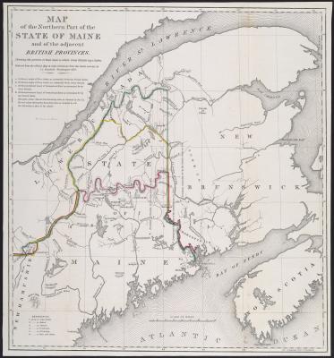
Map of the Northern Part of the State of Maine and the adjacent British Provinces. Shewing the portion of that State to which Great Britain lays claim. Reduced from the official Map A with corrections from the latest surveys by S. L. Dashiell Washington 1
This map shows the three proposed boundary lines, as well as the latest discoveries in the region.
S. L. Dashiell, Washington D.C., 1830
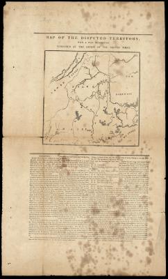
Report and Resolves in Relation to the North-Eastern Boundary. March, 1838. Senate… No. 67…
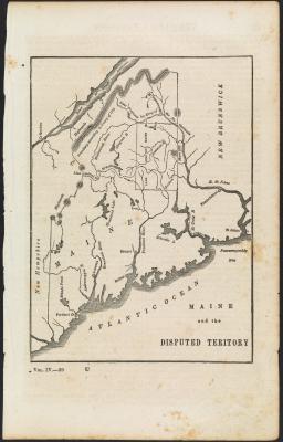
“The disputed territory comprehends nearly seven millions of acres – the joint property of Massachusetts and Maine. It contains 10,705 square miles, being 2,905 square miles, or 1,859,200 acres more than the entire territory of this Commonwealth. A committee of our own Legislature, who visited these lands in 1835, say of the Allagash country which lies within the disputed territory, ‘there can be no doubt, but that this is the best timbered tract in Maine, if not in the world.” Again, they say, ‘this timber is indispensable in the finish, and ornamental work of all our dwellings; and to this territory must nearly all the Atlantic towns and cities look for a supply…’
“Of these lands more than three millions of acres belong to this Commonwealth, and are worth at the present time at least fifty cents per acre, making an interest of more than one million and a half of dollars. But as these lands will increase in value as the settlement extends, it is highly probable that the Commonwealth, if left to the quiet enjoyment of her rightful possessions, will realize a much larger sum.”
“Of these lands more than three millions of acres belong to this Commonwealth, and are worth at the present time at least fifty cents per acre, making an interest of more than one million and a half of dollars. But as these lands will increase in value as the settlement extends, it is highly probable that the Commonwealth, if left to the quiet enjoyment of her rightful possessions, will realize a much larger sum.”
Commonwealth of Massachusetts, 1838
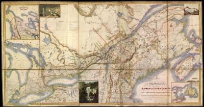
Map of Provinces of Lower and Upper Canada, Nova Scotia, New Brunswick, Newfoundland, & Prince Edward Island, with a large portion of the United States, Compiled from the latest and most approved Astronomical observations, authorities, and recent surveys
This map only shows the British claim line in Maine. The images on this map are not original, but were pasted on later. The Upper and Lower Provinces of Canada were established in 1791, but abolished and replaced with the United Province of Canada in 1841 as a result of all the political confusion surrounding the boundary dispute.
Joseph Bouchette, 1839
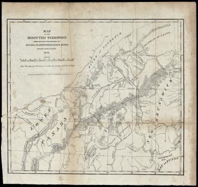
Map of the Seat of War, showing the disputed territory, and the boundary lines claimed by Maine & Great Britain
This map shows topographic features, ranges and townships of the Public Lands Survey, military roads, mail routes and other major roads. In addition to the proposed boundary lines, this map also shows American and British military camps in the disputed region.
Wilbur Curtiss, 1839
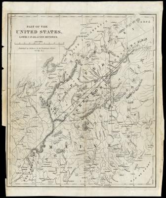
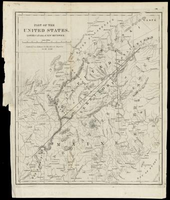
Part of the United States, Lower Canada and New Brunswick.
Mason’s map shows incredible detail of Lower Canada and Northern Maine, much of which is lacking in the maps previously listed. Although Mason’s maps were originally produced for British magazines, this edition was published in New York for the American public.
Jemima M. Mason, The Westminster Review, New York, 1840
A New Map of Maine by H. S. Tanner
This hand-colored map was originally published in Tanner’s New Universal Atlas. The atlas was intended to reach a broader market, with smaller pages, more color, and an expanded section on international geography. As one might expect, the northern counties are still largely undeveloped.
Henry Schenck Tanner, Philadelphia, 1840
A New Map of Maine
When Samuel Augustus Mitchell was a schoolteacher, he found geography books and maps to be far below his expectations. Thus, he trained himself in the art of printed maps. He teamed up with engraver J. H. Young and became one of the finest American map publishers of the nineteenth century. His family maintained the business for over 60 years. He also produced several maps for Tanner’s New Universal Atlas during the latter half of his life.
Samuel Augustus Mitchell, Philadelphia, 1840
Report of the British Commissioners appointed to survey the Territory in dispute between Great Britain and the United States of America, on the North-Eastern Boundary of the United States. April 16th, 1840. With an Appendix. London:
George William Featherstonhaugh was a brilliant and well respected British-American geographer, and also the first geologist to the U.S. government. He surveyed portions of the Louisiana Purchase and was one of the trusted proposers of the Albany Schenectady Railroad. Later, when Louis Napoleon led a military coup against the King of France, Featherstonhaugh arranged the royal family’s escape through Le Havre to England.
Richard Zachariah Mudge was an English officer and surveyor of the Royal Engineers, known for his work on the Ordnance Survey. The pair was selected by the British government in 1838 to help settle the Maine boundary dispute. In spring of 1939, they began their expedition to map the details surrounding the border. They traveled to Fredericton in New Brunswick, Quebec, and Niagara, before returning to England with the latest news. They reported that the United States’ claim line was inconsistent with the physical geography of the region as well as the terms of the treaty.
Richard Zachariah Mudge was an English officer and surveyor of the Royal Engineers, known for his work on the Ordnance Survey. The pair was selected by the British government in 1838 to help settle the Maine boundary dispute. In spring of 1939, they began their expedition to map the details surrounding the border. They traveled to Fredericton in New Brunswick, Quebec, and Niagara, before returning to England with the latest news. They reported that the United States’ claim line was inconsistent with the physical geography of the region as well as the terms of the treaty.
George William Featherstonhaugh, Richard Zachariah Mudge, London, 1840
Observations upon the Treaty of Washington, signed August 9, 1842; with the treaty annexed. Together with a map, to illustrate the boundary line as established by the treaty between Her Majesty’s colonies of New Brunswick and Canada and the United States
George William Featherstonhaugh, London, 1842
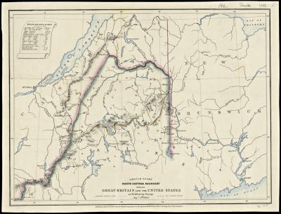
Sketch of the North Eastern Boundary between Great Britain and the United States as Settled by Treaty Augt. 9th, 1842 by James Wyld
Published less than two weeks after the Webster-Ashburton Treaty of Washington, this map was one of the first to show Maine’s new border on Great Britain.
James Wyld, London, 1842
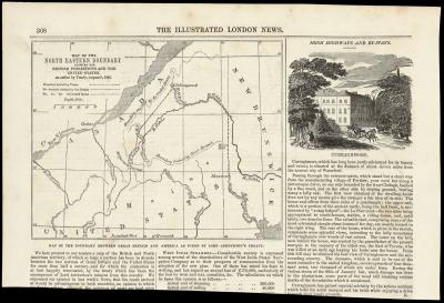
Map of the North Eastern Boundary between the British possessions and the United States, as settled by Treaty, August 9, 1842.
The Illustrated London News happily announced the end of the boundary dispute; “We here present to our readers a map of the British and North American territory, of which so large a portion has been in dispute between the two nations of Great Britain and the United States for more than half a century, and for which the contention is at last happily terminated, by the treaty which has been the consequence of Lord Ashburton’s mission from this country.”
The Illustrated London News, 1842
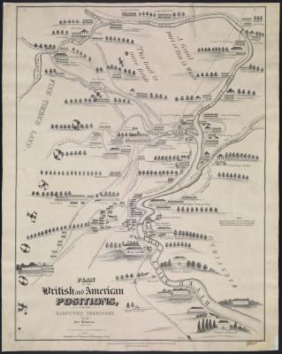
Plan of the British and American Positions, on the Disputed Territory by an eye witness.
During the Aroostook War, lumberjacks from both sides continued to cut timber in the disputed territory during the winter of 1838. On December 29, the Eaton family spotted lumberjacks from New Brunswick felling trees on their land in present-day Caribou. An informal American militia escorted the Eaton family to speak with the woodcutters. When the perceived trespassers refused to leave, both sides drew arms. Meanwhile, three nearby Canadians were attacked by a black bear, defending her cub. The Americans heard the shots and returned fire, but not a single bullet met its mark, and the Canadians retreated to tend to the bear attack.
Two months later, the Maine Legislature authorized Major General Isaac Hodsdon to lead 1,000 volunteers to the upper Aroostook River. There they were notified that the British Army had arrived from the West Indies, with the support of the Mohawk Nation. This was enough to mobilize Mainers to join the effort. Militiamen organized in Bangor and met the Hodsdon at Fort Fairfield.
Two months later, the Maine Legislature authorized Major General Isaac Hodsdon to lead 1,000 volunteers to the upper Aroostook River. There they were notified that the British Army had arrived from the West Indies, with the support of the Mohawk Nation. This was enough to mobilize Mainers to join the effort. Militiamen organized in Bangor and met the Hodsdon at Fort Fairfield.
Nathaniel Dearborn, District Court of Massachusetts, Boston, 1843
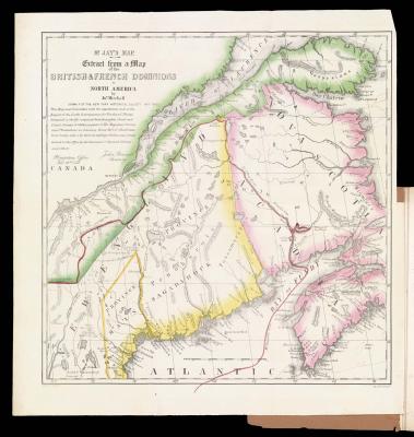
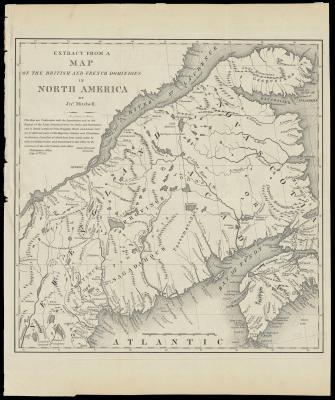
A Memoir on the Northeastern Boundary, in Connexion with Mr. Jay’s Map, by the Hon. Albert Gallatin, LL.D., President of the N.Y. Historical Society, formerly one of the Commissioners under the Treaty of Ghent, Minister to Great Britain, &c… Together with
Albert Gallatin, Daniel Webster, New York, 1843
Biographical Sketch of John G. Deane and brief mention of his connection with Northeastern Boundary of Maine…
John Gilmore Deane’s son, Llewellyn Deane, wrote this book nearly fifty years after his father’s death. John Deane grew up in Massachusetts, later moving to Ellsworth, Maine as a young man. He served in the Court of Common Pleas in Hancock County in 1810, counselor in the Supreme Court in 1814, and several other offices. But, when Portland’s town records were burned in the great fire of 1866, and thus it is impossible to know exactly which offices John held or when. According to Llewellyn, ”By means of his hunting tours and these extended excursions Mr. Deane acquired a very thorough experience with life in the woods, and became most peculiarly well fitted for the performance of the public duties which devolved upon him later, in connection with the Northeastern Boundary of Maine.” John was apparently fascinated with the boundary dispute and the potential for Maine’s timber, traveled often to the “fine lands in the northern part of our State,” and wrote several reports:
1827. Report on the Northeastern Boundary question.
1828. Report upon the Northeastern Boundary question.
1830. Resolve of the Legislature allowing him $170 for negotiating release of land claims with Penobscot Indians.
1831. Report of committee on State Lands, of which he was chairman.
1831 Report as chairman of the Committee on the Northeastern Boundary.
1831 Resolve granting him half a township of land.
1831. Letter to Governor Samuel E. Smith about the Northeastern Boundary.
1839. Resolve paying him $465.03 for locating the Northeastern Boundary Line under resolve of March 23, 1838.
Llewellyn Deane, Washington D.C., 1887
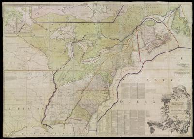
A Map of the British Colonies in North America with the Roads, Distances, Limits, and extent of the Settlements, Humbly Inscribed to the Right Honourable the Earl of Halifax, and the other Right Honourable the Lords Commissioners for Trade & Plantations b
During the Webster-Ashburton Treaty of Washington in 1842, Daniel Webster found this map in the Paris Archives while looking for pro-American evidence. Supposedly, Benjamin Franklin marked the map in red ink, showing the disputed region as belonging to the British, in an effort to persuade Maine and Massachusetts to accept the agreement and avoid further bloodshed. Often referred to as “the most important map in American history,” it was also the centerpiece for the Treaty of Paris.
John Mitchell, William Faden, London, 1775


