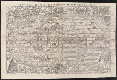
Hans Holbein, Simon Grynaus, and Sebastian Munster, Woodblock, Basle, 1555
First impressions of Native Americans were often drawn from maps like these. This piece was originally published in 1532, as an insert in the travel report, Novis Orbis Regionum ac Insularum veteribus incognitarum (Regions of the Old and New Worlds), to which Sebastian Munster also wrote the commentary. It does not reflect the contemporary knowledge provided by Magellan’s successful circumnavigation of the world in 1522. It does, however, show North America as its own continent. They called it Terra de Cuba, rather than Terra de Cuba Asie Partis (Land of Cuba, Part of Asia), as it was referred to on previous maps. The border, engraved by Hans Holbein, depicts the world’s curious inhabitants, some of them real, many of them mythological. The Ubangi people of the Congo (who are real) pose next to an elephant and two winged snakes in the top left corner. The Natives of South America feast on fellow humans in the lower left. Note the degree of clothing on these figures. The images of North American Natives in the top right, with bare legs and chests, convey their uncivilized nature, while the cannibals are completely nude and therefore savage. These wild and imaginary images are characteristic of medieval maps.
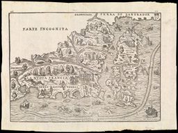
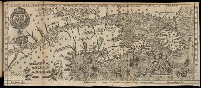
Giovanni Battista Ramusio, Woodblock, Venice, 1565
This is considered the first map of New England, richly illustrated with Native Americans, Europeans, plants, animals, ships, sea monsters and fishermen. Maps of the New World often depicted the land’s blossoming economic opportunities, featuring the bountiful fish, timber for shipbuilding, and mammals for fur. The natives in this map are woven into their landscape, as if they are part of the profitable land.
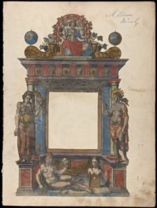
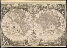
Abraham Ortelius, Copper Engraving, Antwerp, 1570
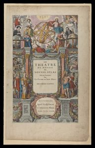
On the back side of this title page, Ortelius gives us a detailed description of the allegorical figures, revealing the racial theories of the sixteenth century European intellectual. The frontispiece depicts a stage; the theater of the world. The globe has long been represented by Mother Earth, who personifies the fertility of nature. Thus it is only natural that female figures came to represent the continents. Above the stage, watching over all that is discovered, is Europe, wearing the crown and grasping the scepter. Her left hand grasps the rudder as she steers the globe. She wears, not only the finest clothing of all the women, but the most clothing, another indication of her wealth and civilization. Asia, the second most civilized, is clad in eastern jewels and silks, offering incense to her superior. On her left is Africa, surrounded by beams of light, which refers to the story of Phaethon, who attempted to drive the chariot of the Sun too close to the Earth. For this reason she is too hot to wear any clothing. She is simply draped by a long cloth. Beneath them all is America, completely nude and unashamed. In her left hand she holds the severed head of a defeated opponent- in her right, the club she used to defeat him. The description reads, “She roasts their bodies, torn to quivering pieces, in smouldering flames, or she boils them in a hot copper kettle. Or, should the frenzy of hunger overcome her, she might devour their limbs, still raw and freshly slain dripping with black-red blood. She feeds on the flesh and on the blood of these wretches: a crime horrible to see and horrible to relate.” She embodies all the savage customs of her people. The last figure is only partial. She represents the unknown land of Australia.
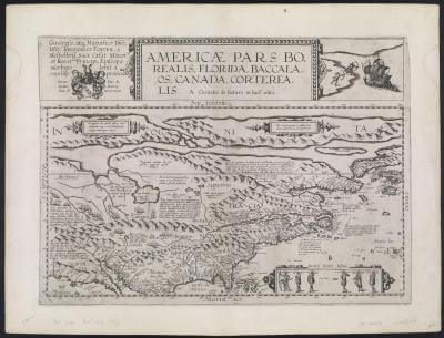
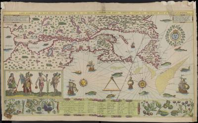
Cornelis de Jode, Copper Engraving, Antwerp, 1593
Native American imagery was often inspired by the uncultured accounts of explorers. The native figures featured in the bottom right corner were based on the illustrations and reports of John White, a colonist and mapmaker during the expedition to North Carolina in 1585. The skirmish in the upper right corner was based on Sir Martin Frobisher’s accounts of the natives of Baffin Island.
Arnold Florent van Langren, Henricus F. Langren, Petrus Plancius, Jan Baptista Vrients, Copper Engraving, Antwerp, 1596
This impressive double hemisphere follows the same arrangement and imagery as Ortelius’ title page, excluding Australia.
Jean Millot and Jan Swelinck, Woodblock, 1612
Hochelaga, featured in the upper left corner, was an Iroquoian village at the head of the St, Lawrence River. Many linguists think Hochelaga is either the French version of the Laurentian word (a language from the Iroquoian family), osekare (beaver path), or osheaga (big rapids). But there is also a Mohawk interpretation of the word Osheaga, “people of the shaking hands.” Legend has it that upon meeting the Iroquois, Jacques Cartier, the first man to describe and map the Gulf and Shores of the Saint Lawrence, puzzled them with the European custom of shaking hands.
Samuel de Champlain, Hand-colored Copper Engraving, 1612
Soon after Champlain returned to France in 1610, he began writing his memoir, which included maps of his discoveries, descriptions of the native inhabitants, and the plentiful natural resources. Published the year before his memoir, this was the first map of New France available to the French public. In his memoir, Champlain wrote, “Of all the most useful and excellent arts, that of navigation has always seemed to me to occupy the first place… By it we attract and bring to our own land all kinds of riches, by it the idolatry of paganism is overthrown and Christianity proclaimed throughout all the regions of the earth.” It is obvious, however, that the artist had never seen a Native American before, as his depictions have distinctly European features.
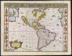
Jodocus Hondius and Gerard Mercator, Hand-colored Copper Engraving, Amsterdam, 1628
Jodocus Hondius, Jan Jansson, and Gerard Mercator, Hand-colored Copper Engraving, Amsterdam, 1638
Unlike many others of its kind, this map shows some understanding of cultural diversity through images of wardrobe variation in the side panels. The east coast is still studded with many of the original Algonquin place names, which would change dramatically as the Europeans continued to map and settle the New World. The Native figures and their costumes were copied from Willem Janszoon Bleau’s 1608 map of the Western Hemisphere, which was commonly used by competing mapmakers. As a result, these images became quite familiar to map collectors, and the stereotypes they carried were used in contrast to European figures. On the backside of this map, the English author, Dr. James Walker, wrote, “but the barbarism of manners, Idolatry in Religion, and…. Ignorance of the people, such as hardly distinguisheth them from bruits; else they would not have taken moral men to be immortal gods, as they did the Spaniards, at their first arrival. But it was not long before the Tyrants cudgeled their simplicity, and by their cruelty appeared to them rather Devils from Hell than Saints from Heaven.”
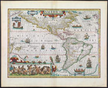
Joan Blaeu and Willem Janszoon Blaeu, Hand-colored Copper Engraving, Amsterdam, 1638
Yet again, we see the four feminine continents on either side of the title; Europe and Asia on the left, America and Africa on the right. America continues to be depicted with the least amount of clothing, her club highlighting her brutality. Above America is one of her people, also quite naked, but European-looking. On her opposite, is Africa. She grasps a parasol, a symbol of her cultural and racial difference. The parasol was often used as an accessory for exotic women from Asia, Africa, and America, in visual art and in theater. Although Europeans also used the parasol, it came to symbolize wealth and power in ancient Egypt, Assyria, and China 4,000 years ago. Thus, it became associated with foreignness, and remains a common clue in exposing the European gaze.
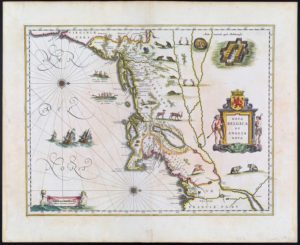
Willem Janszoon Blaeu, Hand-colored Copper Engraving, Amsterdam, 1638.
In addition to the stereotypical images of Native American figures and villages, this map invites the viewer to explore the fruitful resources of the New World.
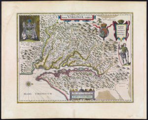
Willem Janszoon Blaeu and Dirck Gryp, Hand-colored Copper Engraving, Amsterdam, 1640
This map was actually made by Jodocus Hondius in 1629. When Blaeu acquired this plate, he simply replaced the publisher information with his own. It was a derivative of John Smith’s map of Virginia, first published in 1612. Smith accompanied the first settlers of Jamestown in 1606. As he explored the area, he recorded the names of Native American villages and their accounts of what lay beyond the territory he covered. It was quite unheard of for a European mapmaker to give credit to the natives who helped him. The engraving in the upper left corner depicts Wahunsenacawh, the chief of Tsenacommacah (more commonly known as Powhatan), smoking a peace pipe.
Cornelis Blaeu, Joan Blaeu, Willem Janszoon Blaeu, Hand-colored Copper Engraving, Amsterdam, 1640
This map was one of the most successful of the seventeenth century. People purchased maps like these, not only for their geographic information, but their stunning appearance and artistic skill. The Native Americans who flank the cartouche are more for decoration than anything else. Their presence emphasizes the great promises of the New World.
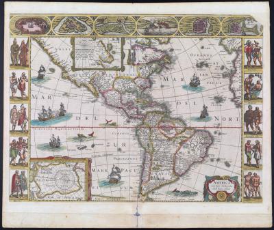
Joan Blaeu, Hand-colored Copper Engraving, 1648

Johannes Jansson, Copper Engraving, 1651

Eva van Alphen and Nicolas Visscher, Hand-colored Copper Engraving, Amsterdam, 1663
This map is based on Captain John Smith’s landmark 1612 map of Virginia, which in turn, was derived from the map by Hondius and Blaeu mentioned earlier. The “Notarum,” or “Notes,” are surrounded by a llama, horned long haired sheep, and Brazilian hunters, representing the native people, plants and animals. Beautifully illustrated and colored, Ogilby’s map details native villages in Chesapeake Bay, mountains, rivers and forests.
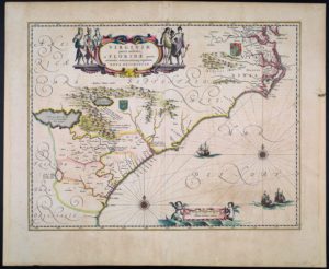
Pieter Goos, Amsterdam, 1666
Although the cartography of the east coast is quite accurate, this was the first map produced for an atlas to depict California as an island. In 1539, Hernán Cortés sent Francisco de Ulloa up the Gulf and Pacific coasts of Baja California, who proved that the region was not an island, but a peninsula. However, the fantacy Island of California was revived in the seventeenth century, and thus this map marks the beginning of a long line of cartographic mythology of the west coast.