Sort By:
AuthorHenry Stevens, Son & Stiles
PublisherHenry Stevens, Son & Stiles
LanguageEnglish
Material TypePaper
Dimensions27 x 19.5 cm
Physical Description1 book: 24 pages
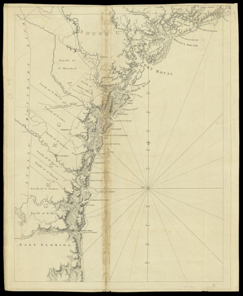
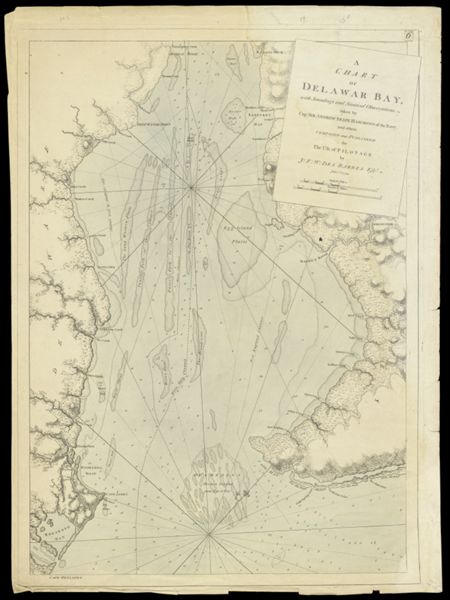
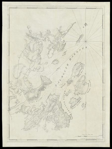
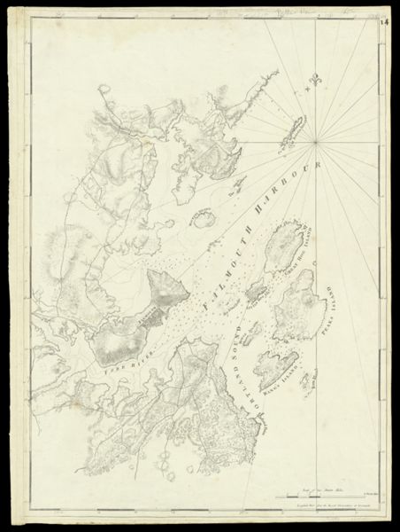
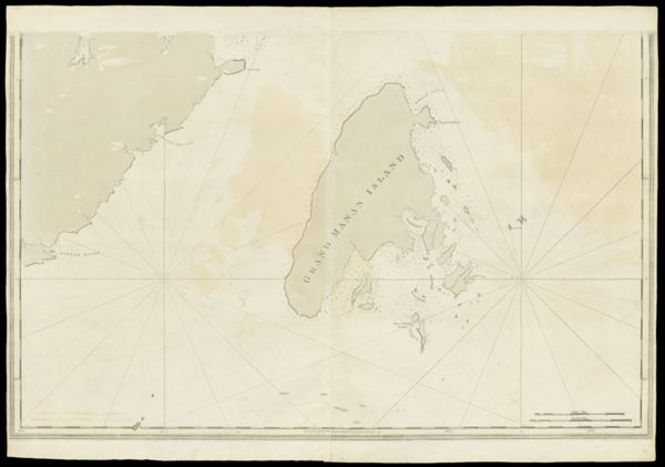
See AlsoA Chart of Delawar Bay.Chart of Coast from Pemaquid Point to Owl's Head Bay [sheet 1 of 2]Chart of Coast from Pemaquid Point to Owl's Head Bay [sheet 2 of 2]Chart of Coast from Pemaquid Point to Owls Head BayChart of Falmouth HarbourChart of Falmouth HarbourChart of Grand Manan IslandChart of Passamaquody BayChart of Penobscot Bay (Upper Part)Chart of Portland Harbour and Islands, and Harbours Adjacent, Extending from the river Kennebec to Wood Island and Winter Harbour, drawn from the survey of Des Barres with additions and corrections by L. Moody.Chart of the Coast from Cape Elizabeth to Musketo IslandChart of the Coast from Cape Elizabeth to Musketo Island Chart of the Coast from Musketo Island to Skuttock PointChart of the Coast Goldsborough to Moose Harbor [Sheet 2 of 3]Chart of the Coast Goldsborough to Moose Harbor [Sheet 3 of 3]Chart of the Coast Goldsborough to Moose HarbourChart of the Coast of GeorgiaChart of the Entrance into Penobscot BayChart of the Entrance into Penobscot BayChart of the Harbours and Rivers between Portland Point and Stage IslandChart of the Sea Coast of New Foundland, New Scotland, New England, New York, New Jersey, with Virginia and Maryland.Charts of the Coast and Harbors of New England [...] [Title page]Coast from Newbury to Cape ElizabethThe Coast of New England.[Boston Harbor Chart Des Barres] [facsimile][Coast of Maine - Two Views of Wolves Islands at Entrance of Passamaquoddy Bay]
LC Call NumberGA369.D43 N67 1937
OCLC82890291
Accession NumberOML-1937-98
SubjectsColonial AmericaDes Barres, Joseph F. W. (Joseph Frederick Wallet), 1729-1824Maine--MapsMaps--Early works to 1800Watermarks
AuthorHenry Stevens, Son & Stiles
PublisherHenry Stevens, Son & Stiles
LanguageEnglish
Material TypePaper
Dimensions27 x 19.5 cm
Physical Description1 book: 24 pages
See AlsoA Chart of Delawar Bay.Chart of Coast from Pemaquid Point to Owl's Head Bay [sheet 1 of 2]Chart of Coast from Pemaquid Point to Owl's Head Bay [sheet 2 of 2]Chart of Coast from Pemaquid Point to Owls Head BayChart of Falmouth HarbourChart of Falmouth HarbourChart of Grand Manan IslandChart of Passamaquody BayChart of Penobscot Bay (Upper Part)Chart of Portland Harbour and Islands, and Harbours Adjacent, Extending from the river Kennebec to Wood Island and Winter Harbour, drawn from the survey of Des Barres with additions and corrections by L. Moody.Chart of the Coast from Cape Elizabeth to Musketo IslandChart of the Coast from Cape Elizabeth to Musketo Island Chart of the Coast from Musketo Island to Skuttock PointChart of the Coast Goldsborough to Moose Harbor [Sheet 2 of 3]Chart of the Coast Goldsborough to Moose Harbor [Sheet 3 of 3]Chart of the Coast Goldsborough to Moose HarbourChart of the Coast of GeorgiaChart of the Entrance into Penobscot BayChart of the Entrance into Penobscot BayChart of the Harbours and Rivers between Portland Point and Stage IslandChart of the Sea Coast of New Foundland, New Scotland, New England, New York, New Jersey, with Virginia and Maryland.Charts of the Coast and Harbors of New England [...] [Title page]Coast from Newbury to Cape ElizabethThe Coast of New England.[Boston Harbor Chart Des Barres] [facsimile][Coast of Maine - Two Views of Wolves Islands at Entrance of Passamaquoddy Bay]
LC Call NumberGA369.D43 N67 1937
OCLC82890291
Accession NumberOML-1937-98
SubjectsColonial AmericaDes Barres, Joseph F. W. (Joseph Frederick Wallet), 1729-1824Maine--MapsMaps--Early works to 1800Watermarks
![Chart of the Coast Goldsborough to Moose Harbor [Sheet 2 of 3]](https://cdn1.historyit.com/iiif/2/5f34291499c4a6.60628694/685affc62f78a3.31051526.jpg/full/!600,600/0/default.jpg?no_errors=1)
AuthorHenry Stevens, Son & Stiles
PublisherHenry Stevens, Son & Stiles
LanguageEnglish
Material TypePaper
Dimensions27 x 19.5 cm
Physical Description1 book: 24 pages
See AlsoA Chart of Delawar Bay.Chart of Coast from Pemaquid Point to Owl's Head Bay [sheet 1 of 2]Chart of Coast from Pemaquid Point to Owl's Head Bay [sheet 2 of 2]Chart of Coast from Pemaquid Point to Owls Head BayChart of Falmouth HarbourChart of Falmouth HarbourChart of Grand Manan IslandChart of Passamaquody BayChart of Penobscot Bay (Upper Part)Chart of Portland Harbour and Islands, and Harbours Adjacent, Extending from the river Kennebec to Wood Island and Winter Harbour, drawn from the survey of Des Barres with additions and corrections by L. Moody.Chart of the Coast from Cape Elizabeth to Musketo IslandChart of the Coast from Cape Elizabeth to Musketo Island Chart of the Coast from Musketo Island to Skuttock PointChart of the Coast Goldsborough to Moose Harbor [Sheet 2 of 3]Chart of the Coast Goldsborough to Moose Harbor [Sheet 3 of 3]Chart of the Coast Goldsborough to Moose HarbourChart of the Coast of GeorgiaChart of the Entrance into Penobscot BayChart of the Entrance into Penobscot BayChart of the Harbours and Rivers between Portland Point and Stage IslandChart of the Sea Coast of New Foundland, New Scotland, New England, New York, New Jersey, with Virginia and Maryland.Charts of the Coast and Harbors of New England [...] [Title page]Coast from Newbury to Cape ElizabethThe Coast of New England.[Boston Harbor Chart Des Barres] [facsimile][Coast of Maine - Two Views of Wolves Islands at Entrance of Passamaquoddy Bay]
LC Call NumberGA369.D43 N67 1937
OCLC82890291
Accession NumberOML-1937-98
SubjectsColonial AmericaDes Barres, Joseph F. W. (Joseph Frederick Wallet), 1729-1824Maine--MapsMaps--Early works to 1800Watermarks
![Chart of the Coast Goldsborough to Moose Harbor [Sheet 3 of 3]](https://cdn1.historyit.com/iiif/2/5f34291499c4a6.60628694/685b021d898ed5.13396848.jpg/full/!600,600/0/default.jpg?no_errors=1)
AuthorHenry Stevens, Son & Stiles
PublisherHenry Stevens, Son & Stiles
LanguageEnglish
Material TypePaper
Dimensions27 x 19.5 cm
Physical Description1 book: 24 pages
See AlsoA Chart of Delawar Bay.Chart of Coast from Pemaquid Point to Owl's Head Bay [sheet 1 of 2]Chart of Coast from Pemaquid Point to Owl's Head Bay [sheet 2 of 2]Chart of Coast from Pemaquid Point to Owls Head BayChart of Falmouth HarbourChart of Falmouth HarbourChart of Grand Manan IslandChart of Passamaquody BayChart of Penobscot Bay (Upper Part)Chart of Portland Harbour and Islands, and Harbours Adjacent, Extending from the river Kennebec to Wood Island and Winter Harbour, drawn from the survey of Des Barres with additions and corrections by L. Moody.Chart of the Coast from Cape Elizabeth to Musketo IslandChart of the Coast from Cape Elizabeth to Musketo Island Chart of the Coast from Musketo Island to Skuttock PointChart of the Coast Goldsborough to Moose Harbor [Sheet 2 of 3]Chart of the Coast Goldsborough to Moose Harbor [Sheet 3 of 3]Chart of the Coast Goldsborough to Moose HarbourChart of the Coast of GeorgiaChart of the Entrance into Penobscot BayChart of the Entrance into Penobscot BayChart of the Harbours and Rivers between Portland Point and Stage IslandChart of the Sea Coast of New Foundland, New Scotland, New England, New York, New Jersey, with Virginia and Maryland.Charts of the Coast and Harbors of New England [...] [Title page]Coast from Newbury to Cape ElizabethThe Coast of New England.[Boston Harbor Chart Des Barres] [facsimile][Coast of Maine - Two Views of Wolves Islands at Entrance of Passamaquoddy Bay]
LC Call NumberGA369.D43 N67 1937
OCLC82890291
Accession NumberOML-1937-98
SubjectsColonial AmericaDes Barres, Joseph F. W. (Joseph Frederick Wallet), 1729-1824Maine--MapsMaps--Early works to 1800Watermarks
![[Boston Harbor Chart Des Barres] [facsimile]](https://cdn1.historyit.com/iiif/2/5f34291499c4a6.60628694/67ab9d2566f715.86636289.jpg/full/!600,600/0/default.jpg?no_errors=1)
AuthorHenry Stevens, Son & Stiles
PublisherHenry Stevens, Son & Stiles
LanguageEnglish
Material TypePaper
Dimensions27 x 19.5 cm
Physical Description1 book: 24 pages
See AlsoA Chart of Delawar Bay.Chart of Coast from Pemaquid Point to Owl's Head Bay [sheet 1 of 2]Chart of Coast from Pemaquid Point to Owl's Head Bay [sheet 2 of 2]Chart of Coast from Pemaquid Point to Owls Head BayChart of Falmouth HarbourChart of Falmouth HarbourChart of Grand Manan IslandChart of Passamaquody BayChart of Penobscot Bay (Upper Part)Chart of Portland Harbour and Islands, and Harbours Adjacent, Extending from the river Kennebec to Wood Island and Winter Harbour, drawn from the survey of Des Barres with additions and corrections by L. Moody.Chart of the Coast from Cape Elizabeth to Musketo IslandChart of the Coast from Cape Elizabeth to Musketo Island Chart of the Coast from Musketo Island to Skuttock PointChart of the Coast Goldsborough to Moose Harbor [Sheet 2 of 3]Chart of the Coast Goldsborough to Moose Harbor [Sheet 3 of 3]Chart of the Coast Goldsborough to Moose HarbourChart of the Coast of GeorgiaChart of the Entrance into Penobscot BayChart of the Entrance into Penobscot BayChart of the Harbours and Rivers between Portland Point and Stage IslandChart of the Sea Coast of New Foundland, New Scotland, New England, New York, New Jersey, with Virginia and Maryland.Charts of the Coast and Harbors of New England [...] [Title page]Coast from Newbury to Cape ElizabethThe Coast of New England.[Boston Harbor Chart Des Barres] [facsimile][Coast of Maine - Two Views of Wolves Islands at Entrance of Passamaquoddy Bay]
LC Call NumberGA369.D43 N67 1937
OCLC82890291
Accession NumberOML-1937-98
SubjectsColonial AmericaDes Barres, Joseph F. W. (Joseph Frederick Wallet), 1729-1824Maine--MapsMaps--Early works to 1800Watermarks
![Chart of Coast from Pemaquid Point to Owl's Head Bay [sheet 1 of 2]](https://cdn1.historyit.com/iiif/2/5f34291499c4a6.60628694/685c0e52b205f5.14283703.jpg/full/!600,600/0/default.jpg?no_errors=1)
AuthorHenry Stevens, Son & Stiles
PublisherHenry Stevens, Son & Stiles
LanguageEnglish
Material TypePaper
Dimensions27 x 19.5 cm
Physical Description1 book: 24 pages
See AlsoA Chart of Delawar Bay.Chart of Coast from Pemaquid Point to Owl's Head Bay [sheet 1 of 2]Chart of Coast from Pemaquid Point to Owl's Head Bay [sheet 2 of 2]Chart of Coast from Pemaquid Point to Owls Head BayChart of Falmouth HarbourChart of Falmouth HarbourChart of Grand Manan IslandChart of Passamaquody BayChart of Penobscot Bay (Upper Part)Chart of Portland Harbour and Islands, and Harbours Adjacent, Extending from the river Kennebec to Wood Island and Winter Harbour, drawn from the survey of Des Barres with additions and corrections by L. Moody.Chart of the Coast from Cape Elizabeth to Musketo IslandChart of the Coast from Cape Elizabeth to Musketo Island Chart of the Coast from Musketo Island to Skuttock PointChart of the Coast Goldsborough to Moose Harbor [Sheet 2 of 3]Chart of the Coast Goldsborough to Moose Harbor [Sheet 3 of 3]Chart of the Coast Goldsborough to Moose HarbourChart of the Coast of GeorgiaChart of the Entrance into Penobscot BayChart of the Entrance into Penobscot BayChart of the Harbours and Rivers between Portland Point and Stage IslandChart of the Sea Coast of New Foundland, New Scotland, New England, New York, New Jersey, with Virginia and Maryland.Charts of the Coast and Harbors of New England [...] [Title page]Coast from Newbury to Cape ElizabethThe Coast of New England.[Boston Harbor Chart Des Barres] [facsimile][Coast of Maine - Two Views of Wolves Islands at Entrance of Passamaquoddy Bay]
LC Call NumberGA369.D43 N67 1937
OCLC82890291
Accession NumberOML-1937-98
SubjectsColonial AmericaDes Barres, Joseph F. W. (Joseph Frederick Wallet), 1729-1824Maine--MapsMaps--Early works to 1800Watermarks
![Chart of Coast from Pemaquid Point to Owl's Head Bay [sheet 2 of 2]](https://cdn1.historyit.com/iiif/2/5f34291499c4a6.60628694/685c10bfc61226.46337615.jpg/full/!600,600/0/default.jpg?no_errors=1)
AuthorHenry Stevens, Son & Stiles
PublisherHenry Stevens, Son & Stiles
LanguageEnglish
Material TypePaper
Dimensions27 x 19.5 cm
Physical Description1 book: 24 pages
See AlsoA Chart of Delawar Bay.Chart of Coast from Pemaquid Point to Owl's Head Bay [sheet 1 of 2]Chart of Coast from Pemaquid Point to Owl's Head Bay [sheet 2 of 2]Chart of Coast from Pemaquid Point to Owls Head BayChart of Falmouth HarbourChart of Falmouth HarbourChart of Grand Manan IslandChart of Passamaquody BayChart of Penobscot Bay (Upper Part)Chart of Portland Harbour and Islands, and Harbours Adjacent, Extending from the river Kennebec to Wood Island and Winter Harbour, drawn from the survey of Des Barres with additions and corrections by L. Moody.Chart of the Coast from Cape Elizabeth to Musketo IslandChart of the Coast from Cape Elizabeth to Musketo Island Chart of the Coast from Musketo Island to Skuttock PointChart of the Coast Goldsborough to Moose Harbor [Sheet 2 of 3]Chart of the Coast Goldsborough to Moose Harbor [Sheet 3 of 3]Chart of the Coast Goldsborough to Moose HarbourChart of the Coast of GeorgiaChart of the Entrance into Penobscot BayChart of the Entrance into Penobscot BayChart of the Harbours and Rivers between Portland Point and Stage IslandChart of the Sea Coast of New Foundland, New Scotland, New England, New York, New Jersey, with Virginia and Maryland.Charts of the Coast and Harbors of New England [...] [Title page]Coast from Newbury to Cape ElizabethThe Coast of New England.[Boston Harbor Chart Des Barres] [facsimile][Coast of Maine - Two Views of Wolves Islands at Entrance of Passamaquoddy Bay]
LC Call NumberGA369.D43 N67 1937
OCLC82890291
Accession NumberOML-1937-98
SubjectsColonial AmericaDes Barres, Joseph F. W. (Joseph Frederick Wallet), 1729-1824Maine--MapsMaps--Early works to 1800Watermarks