

↑ Parent: [Homann Heirs Composite Atlases] 3
Collection: Smith Collection
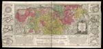
Name: Charte Geographique De La Campagne Du Haut Rhin Pour L'annee MDCCXXXIV Contenant Tous les Mouvemens Marches et Contremarches Des Armes Imperiales et Francoises Comme de Meme Une Designation du Rhine Puis Le Lac || Geographic Map of the Campaign of the Upper Rhine for the year 1734 Containing All the Movement and Steps of the Imperial Weapons and Francoises as the same designation of the Rhine and The Lake
Barcode:
Image Number:
Creator:
Date Created:
Date Published:
Alternative Title: Neu Brefsach, eine regulirte vestung jenseit des Rheins...; Alt Breysfach die Hauptstadt im Breissgau und vortrefflich...; Strassburg die haumptstadt in Nieder Elsassvormalss eine bermte...; Fort Louys, eine vom Konig Ludovico dem XIV. A. 1686 Hagenau...; Landau an dem Fluss Queisswar vor diesem eine Reichs Stadt...; Philippsburg eine beruhmte Reichsfestung am Rhein, im Stift Speyer,..; Manheim eine Hauptfestung in der untern Psaltz, wo der...; Mainz Hauptstadt, principal Festung und Residenz dieses...; Mainz Hauptstadt, principal Festung und Residenz dieses...
Notes: Colored outline and wash. From Atlas Novus. "Oettinger, Johannes, 1577-1633" is LOC's authorized name for a much older mapmaker, but Tooley has two entries for Johannes Freidrich Oettinger, one who is much older and one from the 18th century [6219, the one assigned for this record]. CERL has a "Oetinger, Johannes Friedrich" whose dates of activity was the single year 1778. ULAN lists simply the name "Oetinger".
Permanent URL: