

↑ Parent: Atlas Accompanying Greenleaf's Map and Statistical Survey of Maine.
Collection: Osher Map Library Collection
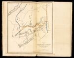
Name: Sketch of the imaginary ranges of highlands reported by the British surveyors under the Treaty of Ghent, as extending across the State of Maine.
Barcode:
Image Number:
Creator:
Date Created:
Date Published:
Alternative Title: Plate III.
Permanent URL: