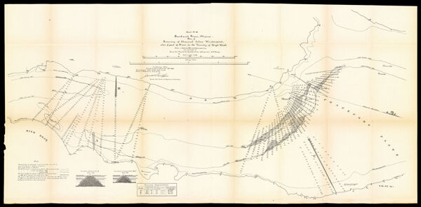
Sheet No. III Penobscot River, Maine - Plan of Resurvey of Channel below Winterport, also of Part of River, in the Vicinity of High Head. Made in September 1891, by A.C Roth, Assist. Engnr. under the direction of Lieut. Col. Jared A. Smith, Corps of Engineers, U.S. ArmyCreatorSmith, Jared A. (Jared Augustine), 1840-1910United States. Army. Corps of Engineers.
PublisherUnited States. Army. Corps of Engineers. Engineer Office
Date/Date Range Produced1892
LanguageEnglish
Region DepictedBangor, MaineBrewer, MainePenobscot River
Map TypeNautical charts
DimensionsH 32 x W 82 cm
Material TypePaper
OCLC1004274239
Accession NumberOS-1891-76.1
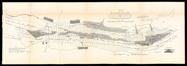
See AlsoSheet No. II Map of Portion of Penobscot River, Maine between Stearn's Mill and Crosby's Narrows Showing Area under contract to be dredged in front of Stearn's Mill, also The condition of Shoal and the Location of two Jetties for contracting the channel above Crosby's Narrows.Sheet No. III Penobscot River, Maine - Plan of Resurvey of Channel below Winterport, also of Part of River, in the Vicinity of High Head. Made in September 1891, by A.C Roth, Assist. Engnr. under the direction of Lieut. Col. Jared A. Smith, Corps of Engineers, U.S. Army
DonorOsher
SubjectsBangor (Me.)Brewer (Me.)HarborsMaine--MapsNautical chartsPenobscot River (Me.)RiversUnited States. Army. Corps of Engineers