Showing 1531-1540 of 109480 results

Sort By:

Map depicting the final Allied offensive in Europe, July-November, 1918.
Date/Date Range Produced: 1918
Language:
Region Depicted:
Map Type:
Dimensions: 89 x 77
LC Call Number: G5721.S65.M3 1918
OCLC: 936180509
Accession Number: OML-1918-2
Subjects:
Image Number:


American occupation zone in Germany.
Surveyor:
Date/Date Range Produced: 1919
Language:
Region Depicted:
Map Type:
Dimensions: 76 x 81
LC Call Number: G6081.S65.A4 1919
OCLC: 936180563
Accession Number: OML-1919-84
Subjects:
Image Number:


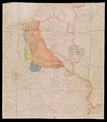
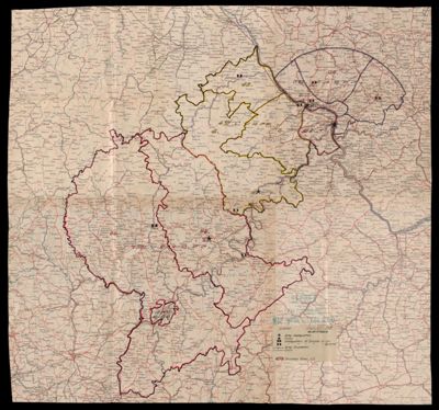
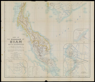
Map of the Kingdom of Siam and its dependencies
Creator:
Date/Date Range Produced: 1900
Physical Description: 1 map on 2 sheets : color ; each 65 x 74 cm
OCLC: 63529781
Accession Number: OML-1900-123
Image Number:


La guerre est l'industrie nationale de la Prusse... attaques, nous ne faisons que nous defendre au nom de la liberte et pour sauver notre existence.
Creator:
Date/Date Range Produced: 1917
Language:
Region Depicted:
Dimensions: 60 x 79 cm
LC Call Number: D522.25.N486 1917
OCLC: 51139377
Accession Number: OML-1917-109
Subjects:
Image Number:


A Map of the City of Portland with its Latest Improvements including a view of the principal buildings engraved and published by John Cullum, Portland.
Creator:
Language:
Region Depicted:
Dimensions: Map: 48.5 x 69 cm on sheet: 51.5 x 71 cm
Printing Process:
Material Type:
LC Call Number: G3734.P8 1836 .C8
OCLC: 893907613
Accession Number: OML-1836-21
Subjects:
Image Number:


Mapa de los Estados Unidos de Mejico, California &c segun lo organizado y definido por las varias actas del congreso de dicha Republica y construido por las mejores autoridades.
Creator:
Date/Date Range Produced: 1847
Language:
Dimensions: 79 x 104
LC Call Number: G4410 1847.D4
OCLC: 887975582
Accession Number: OML-1847-27
Image Number:


A New Map of America exhibiting its natural and political divisions, drawn from the most recent materials.
Creator:
Date/Date Range Produced: 1830
Language:
Region Depicted:
Map Type:
Dimensions: 88 x 83
LC Call Number: G3290 1830.C3
OCLC: 941816944
Accession Number: OML-1830-35
Image Number:


Plan of the sources of Connecticut River.
Creator:
Date/Date Range Produced: 1836
Language:
Region Depicted:
Dimensions: 31 x 38 cm
LC Call Number: G3701.F7 1836.U5
OCLC: 941812036
Accession Number: OML-1836-22
Image Number: