
Alfred Korzybski (1933, 58) famously argued that "the map is not the territory." The full paragraph reads:"Two important characteristics of maps should be noticed. A map is not the territory it represents, but, if correct, it has a similar structure ...

In commemoration of the Civil War Trail throughout the state of Maine, the Osher Map Library has posted on its website all twelve issues of their Harper’s Pictorial History of the Civil War Star Series. This series was published in 1894 in celebrat...
Today's Portland Daily Sun (18 April 2013) has a nice feature about OML's new exhibition, Torn in Two....
NPR has a brilliant piece today by Robert Krulwich on mapping regional communities in the USA, both by tracing the limits to the circulation of dollar bills and patterns of telephone usage.Dirk Brockmann, at Northwestern processed the data ...
"You Are Here: Maps and Meanings" is a new exhibition, running 2 April to 9 November 2013, at the Wisconsin State Historical Society. The exhibition is open 9 am–4 pm, Tuesday through Saturday. From the blurb:We all use maps to find our way. Yet ma...
Language Log has a piece today on the mis-use of "unchartered" (without a charter) when people mean "uncharted" (without a map).The OED entry on "uncharted" ~ and especially "uncharted territory" ~ has not been updated since 1921, when the word was s...
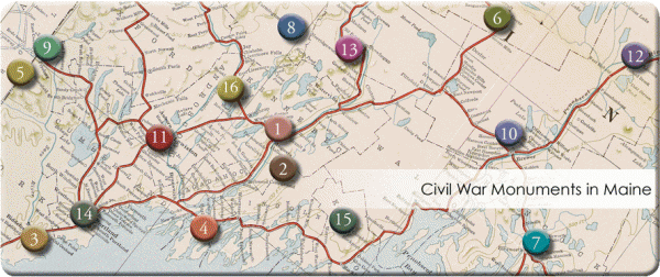
[expand title="EXHIBIT NAVIGATION"] Civil War Monuments in Maine Monuments of Victory Sentinel Soldiers Obelisks and Columns Other Monuments [/expand] Thousands of monuments were created in every state and county throughout the Northern Stat...

The Fall/Winter 2014 issue of Cartography Corner: K-12 Education Outreach Newsletter is available for download. Archive: Cartography Corner: K-12 Education Outreach Newsletter, Spring/Summer 2014 Cartography Corner: K-12 Education Outreach Newsl...

The Spring/Summer 2013 issue of Cartography Corner: K-12 Education Outreach Newsletter is now available for download....
We're very pleased to announce that OML has recently received an impression of a very rare map of the Atlantic, published in Amsterdam ca.1630, by Willem Blaeu (OS-1630-8).As far as we can tell from the literature, this is only the third known impres...