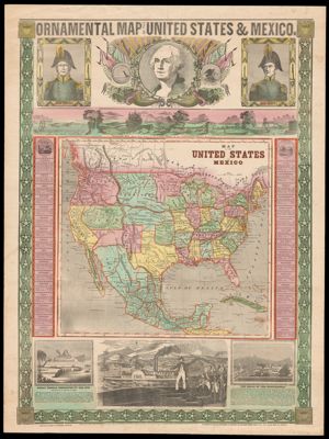
Showing 161-170 of 361 results

Sort By:


Manning's Rutland city and township, West Rutland and Proctor Vermont directory
Publisher:
Date Produced: 1960
Language:
LC Call Number: F59.R88 R87  1960
OCLC: 14150653
Accession Number: CCA,D,M-1960-5
Donor:
Image Number:


Leveling in New Hampshire and Vermont, by Charles J. Clifford, assistant mathematician
Author:
Date Produced: 1934
Language:
Dimensions: Height: 24
Physical Description: 1 book: 1 preliminary leaf, 27 pages, plates, folded map
LC Call Number: QB296.U9 N4 1934
OCLC: 15221693
Accession Number: NA-1934-6
Donor:
Image Number:


Post route map of the New England states (Excepting Maine).
Creator:
Publisher:
Date/Date Range Produced: 1890
Language:
Region Depicted:
Dimensions: folded to 21 x 13 cm.
OCLC: 889347539
Accession Number: OS-1890-71
Donor:
Image Number:


Map of Maine, New Hampshire and Vermont from the  most authentic sources
Map of Maine, New Hampshire and Vermont from the most authentic sources
Publisher:
Date/Date Range Published: 1838
Language:
Dimensions: 36 x 49 cm, folded in cover 13 x 8 cm
LC Call Number: G3720 1838.M3
OCLC: 37931814
Accession Number: ATH-1838-37
Donor:
Image Number: