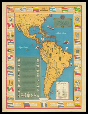
Osher Map Library Sheet Map Collection

4,663 results

The true issue or "thats whats the matter"
Publisher:
Language:
Region Depicted:
Map Type:
Dimensions:
34.5 x 45 cm

Printing Process:
Historical Context:
The American Civil War was about the conflict between the Union and the Confederacy over the issue of slavery and its expansion. The election of Abraham Lincoln in 1860 caused southern states to secede.

LC Call Number:
E461 1864.C8

OCLC:
1487919331

Accession Number:
OML-1864-89

The true issue or

Map of Jerusalem in 1735 based on the writings of Josephus and observations of modern writers.
Printmaker:
Date/Date Range Produced: 1735 - 1965
Language:
Region Depicted:
Map Type:
Dimensions: 69 x 102 cm
Printing Technique:
Historical Context: The panorama depicts Jerusalem in biblical times detailing the buildings, amphitheaters and a densely populated city.
LC Call Number: G7504.A35 1965 H4
OCLC: 1492199126
Accession Number: OML-1965-239
Donor:
Map of Jerusalem in 1735 based on the writings of Josephus and observations of modern writers.

This map illustrates the world wide distribution of Eno's "fruit salt".
Printmaker:
Language:
Region Depicted:
Map Type:
Dimensions: Map: 47 x 89 cm on sheet: 73 x 97 cm on canvas: 78 x 102 cm
Material Type:
LC Call Number: G3201.M8 1926 T3
OCLC: 1108782935
Accession Number: OML-1926-209
Subjects:
This map illustrates the world wide distribution of Eno's

Flags of the Americas
Printmaker:
Publisher:
Language:
Region Depicted:
Map Type:
Dimensions: 54 x 36 cm, on sheet 69 x 52 cm
Material Type:
Historical Context: The Pan American Union was founded in 1890 to promote cooperation between Latin American countries and the United States.
LC Call Number: G5200 1940.H3
OCLC: 12626616
Accession Number: OML-1940-253
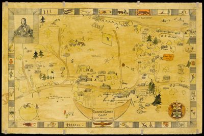
Flags of the Americas

United States--east coast, Maine, Frenchman Bay and Mount Desert Island
Publisher:
Language:
Region Depicted:
Map Type:
Dimensions: 112.5 x 72 cm
LC Call Number: G3732.F7 1970 U23
OCLC: 1492382363
Accession Number: OML-1970-246
United States--east coast, Maine, Frenchman Bay and Mount Desert Island

Sidney Lanier Camp, Eliot, Maine 1929
Printmaker:
Date/Date Range Produced: 1929
Language:
Region Depicted:
Map Type:
Dimensions: Map: 51 x 84.5 cm on sheet: 63.5 x 97 cm
Printing Process:
Material Type:
LC Call Number: G191.78 1929 S6
OCLC: 1492385698
Accession Number: OML-1929-199
Subjects:
Sidney Lanier Camp, Eliot, Maine 1929

Maine
Printmaker:
Publisher:
Language:
Region Depicted:
Map Type:
Dimensions: 105 x 81.5 cm neatline, 101.5 x 86 cm on sheet
Printing Process:
Material Type:
LC Call Number: G3732.A5 1969 S5
OCLC: 1492386346
Accession Number: OML-1969-204
Subjects:
Maine

New York es Kornyeke.
Publisher:
Language:
Region Depicted:
Map Type:
Dimensions: 25 x 20 cm neatline , 30 x 24 on sheet
LC Call Number: G3804.N4:2M3
OCLC: 1493524394
Accession Number: OML-1893-21
New York es Kornyeke.

Statistique comparée de l'état de l'instruction et du nombre des crimes dans les divers Arrondissements des Académies et des Cours Royales de France.
Printmaker:
Publisher:
Language:
Region Depicted:
Map Type:
Dimensions: 54 x 74 cm
Printing Process:
Material Type:
LC Call Number: G5831.E25 1829 G8
OCLC: 1493575759
Accession Number: OML-1829-36
Statistique comparée de l'état de l'instruction et du nombre des crimes dans les divers Arrondissements des Académies et des Cours Royales de France.