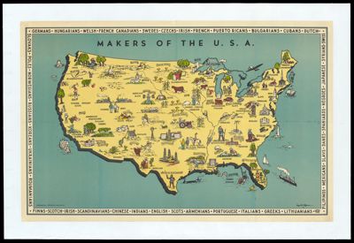
Osher Map Library Sheet Map Collection

4,635 results

Topographical map of the county of Washington, Maine / |c from actual surveys under the direction of H. F. Walling ; drawn, engraved, printed, colored and mounted at H.F. Walling's Map Establishment.
Printmaker:
Publisher:
Language:
Region Depicted:
Map Type:
Dimensions: 152 x 152 cm
Historical Context: Henry Francis Walling was a notable American civil engineer and cartographer. He was known for the geodetic survey of Massachusetts used to prepare states maps. He also prepared atlases with full maps and scientific description.
LC Call Number: G3733.W4 1861 W3
OCLC: 192048879
Accession Number: OML-1861-131
Topographical map of the county of Washington, Maine / |c from actual surveys under the direction of H. F. Walling ; drawn, engraved, printed, colored and mounted at H.F. Walling's Map Establishment.

[ The toad and the flower or the German toad -- Le crapaud et la fleur ou le crapaud allemand ]
Printmaker:
Language:
Region Depicted:
Dimensions:
29 x 39 cm on sheet 40 x 50 cm

Printing Process:
Material Type:
Historical Context:
The manuscript drawing was created during World War I which began in 1914 and would end in 1918. Germany was often represented as a defeated eagle by the French rooster symbolizing courage and aggressiveness. Synave depicts Germany as a giant toad with a pith helmet and France is the delicate rose with its cities being threatened by the Germans.

LC Call Number:
NE 2298.49 1915 S9

OCLC:
1506740101

Accession Number:
OML-1915-142

Subjects:
[ The toad and the flower or the German toad -- Le crapaud et la fleur ou le crapaud allemand ]

Makers of the U.S.A.
Printmaker:
Publisher:
Language:
Region Depicted:
Map Type:
Dimensions: 19.5 x 32 cm neatline, 58 x 88 on sheet, 67 x 98 to edge of mount
Material Type:
LC Call Number: G3701.A5 1943 J4
OCLC: 9550290
Accession Number: OML-1943-178
Makers of the U.S.A.

L'Emprunt de la Liberation
Printmaker:
Publisher:
Language:
Map Type:
Dimensions: 80 x 113.5 cm
Material Type:
LC Call Number: NE 2298.49 1918 F3
OCLC: 1506747848
Accession Number: OML-1918-137
Subjects:
L'Emprunt de la Liberation

Exposition de Universelle de 1900: plan d'ensemble rez-de-chaussee.
Publisher:
Language:
Region Depicted:
Map Type:
Dimensions: Map: 37 x 49.5 cm on sheet: 38.5 x 51 cm folds to: 19 x 10 cm
Printing Technique:
Material Type:
Historical Context: The Exposition Universelle of 1900 was held in Paris to celebrate past achievements and a move to look forward to the future. Many innovations were displayed at the exposition which included a ferris wheel, a moving sidewalk, escalators, fire engines among other inventions. The exposition opened on April 14th and closed on November 12, 1900.
LC Call Number: G5832.P35 1900
OCLC: 1508882037
Accession Number: OML-1900-225
Exposition de Universelle de 1900: plan d'ensemble rez-de-chaussee.

Birds Eye View of the Centennial Buildings and Grounds. : Fairmount Park, Philadelphia 1876.
Publisher:
Language:
Region Depicted:
Map Type:
Dimensions: 38 x 58 cm on sheet 50 x 66 cm
Printing Process:
Material Type:
Historical Context: The Centennial Exhibit ws the first official world's fair held in the United States. It was held in Fairmont Park along the Schuylkill River. Herman J. Schwarzmann was appointed the main designer of the exhibit by the Fairmont Park Commission.
LC Call Number: G3824.P5 1876 T6
OCLC: 1509377349
Accession Number: OML-1876-100
Birds Eye View of the Centennial Buildings and Grounds. : Fairmount Park, Philadelphia 1876.

The popular through car line between the East and West : New York, Boston, Chicago, and St. Louis : the Niagara Falls route.
Publisher:
Language:
Region Depicted:
Map Type:
Dimensions: 39.5 x 99 cm neatline, 42.5 x 101 cm on sheet, 21 x 10 cm folded.
Historical Context: The West Shore Railroad was owned by William Henry Vanderbilt who bought it in 1885 when it was the New York, West Shore and Buffalo Railway. The agreement was handled by banker J.P.Morgan.
LC Call Number: G3711.P3 1901 W9
OCLC: 1509781251
Accession Number: OML-1901-101
The popular through car line between the East and West : New York, Boston, Chicago, and St. Louis : the Niagara Falls route.

Mappemonde en deux hemispheres.
Publisher:
Language:
Region Depicted:
Map Type:
Dimensions: 67.5 x 90 cm on sheet 70 x 92.5 cm
Printing Process:
Material Type:
LC Call Number: G3200 1880.D6
OCLC: 1509785694
Accession Number: OML-1880-99
Mappemonde en deux hemispheres.

United Airlines a gay geography of the main line airway.
Publisher:
Language:
Region Depicted:
Map Type:
Dimensions:
16.5 x 12.5 cm

Historical Context:
Depicts early air travel of the 1930's during the Great Depression during the time of popular pictorial mapmaking. 

LC Call Number:
G3700 1939.W4

OCLC:
1517029974

Accession Number:
OML-1939-214

United Airlines a gay geography of the main line airway.