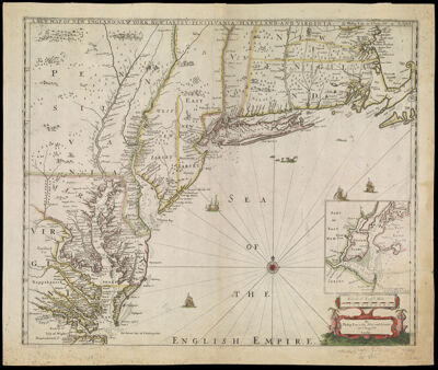
A New Map of New England, New York, New Iarsey, Pensylvania, Maryland, and Virginia. By Philip Lea in Cheap-side London
Creator: Lea, Philip, active 1683-1700Morden, Robert, approximately 1650-1703Thornton, John, 1641-1708Date/Date Range Produced: 1698
Language: EnglishRegion Depicted: ConnecticutDelawareMarylandMassachusettsMiddle Atlantic StatesNew EnglandNew JerseyNew York (State)PennsylvaniaRhode IslandVirginiaMap Type: GeographicalNautical chartsPolitical mapsDimensions: H 49.7 x W 59.2 cm
Printing Process: EngravingMaterial Type: PaperHistorical Context: John Thornton, Robert Morden and Philip Lea collaborated on this map. This state names the Chesapeake Bay and includes eight counties. Also the Maryland and Pennsylvania boundary has been added. Included is "Bohemia", a plantation in northern Chesapeake Bay belonging to Augustine Herrman, explorer, merchant and cartographer.
OCLC: 844377773
Accession Number: OS-1698-5
Donor: OsherSubjects: Thornton, John, 1641-1708