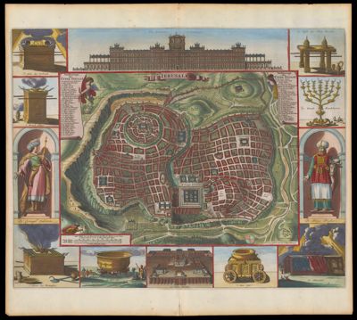
Ierusalem
Creator: Stoopendaal, D.Villalpando, Juan BautistaDate/Date Range Produced: 1702
Language: DutchRegion Depicted: JerusalemMap Type: ViewsDimensions: H 43.2 x W 47.8 cm
Printing Process: EngravingMaterial Type: PaperHistorical Context: In this late version of the Villalpando map, the streets of Jerusalem have been built up and 60 sites have been numbered and identified. Paneled border illustrations portray King Solomon, the high priest, the Tabernacle, the Ark of the Covenant, and altars and furnishings of the Temple. At the top center, Solomon's Temple is portrayed as a classical revival palace of grandiose and visionary proportions, in contrast to Villalpando's simpler portrayal at the bottom center of the map.
Accession Number: OS-1702-1
Donor: OsherSubjects: AltarsBible --GeographyChurch buildingsChurchesFurnitureGeography--Pictorial worksJerusalemJudaismKings, queens, rulers, etc.Maps--Early works to 1800MenorahPriestsRabbisReligionReligious articlesRites and ceremoniesSolomon, King of IsraelTabernacleTemple of Jerusalem (Jerusalem)