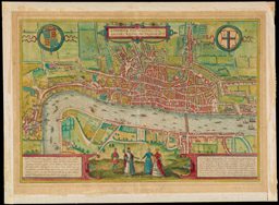
In a period when travel was arduous and a return journey not assured, the wealthy read books to imagine the pleasure of travel without incurring any of its discomforts. Georg Braun thus introduced his six-volume Civitatis orbis terrarum (1572-1618) — a compilation of urban plans and views of 546 cities in Europe, Asia, Africa, and the New World — by observing: “What could be more pleasant than, in one’s own home far from all danger, to gaze in these books at the universal form of earth … and, by looking at the pictures and reading the texts accompanying them, to acquire knowledge which could scarcely be had but by long and difficult journeys?” This hand-colored engraving of Elizabethan London by Frans Hogenberg is typical of the views in Braun’s compendium. An elevated vantage point reveals the city’s layout of the city with its underlying street network. The facades of buildings are carefully rendered, while the foreground figures attired in local dress provide cultural background. The act of travel could be imagined from John Ogilby’s Britannia (1675), a collection of strip maps covering the main roads of England and Wales. Although Ogilby’s work would spawn numerous derivatives in the eighteenth century, including pocket editions, Britannia was too large a volume to be easily taken on the road; it would only have been consulted in the study and armchair!
Georg Braun (1541-1622)
Frans Hogenberg (1535-1590)
Londinum Feracissimi Angliae Regni Metropolis. From Civitatis orbis terrarum (Cologne: ca. 1573). 35 x 50 cm
Osher Collection

https://oshermaps.org/map/484
John Ogilby (1600-1676)
Road from York to Lancaster. From Britannia
(London: 1675). 37 x 47 cm
Osher Collection
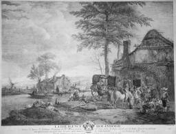
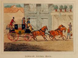
Contemporary paintings and prints reveal the nature of travel in the early modern era. For example, this engraving based on a 1747 painting by Philip Wouwerson, a Dutch painter known for his genre and military scenes, graphically conveys the hardships experienced by the travelers who are about to disembark from the dilapidated coach (the diligence of the title) and enter an uninviting inn. Most likely the weary travelers would find neither a clean, vermin-free bed nor a decent, edible meal. Because inadequate roadside lodgings were the norm at this time, gentlemen of means traveled in their own coaches accompanied by their servants and, whenever possible, stayed as guest in the (perhaps) more salubrious private houses of local hosts. By 1800, new roads and streamlined coach services had cut both travel time and discomfort between urban centers. For example, the trip from Edinburgh to London had been cut from ten or twelve days in the 1750s to just two or three. Passengers still had to endure the constant pitching of the coach; outside passengers, like the coachmen, were also exposed to all wind and weather, from frigid ice to dry dust. Henry Alkin, an English artist known for his etchings of horses and hunting scenes, completed this set of idealized images of coaches just after 1800. The rigors of coach travel would be progressively displaced after 1830 by passenger trains.
https://oshermaps.org/img/flat/tou04.jpg
Jean Mayreau (1690-1762)
La Diligence Holandaise. From an original painting by Philips Wouwerman.
(Paris, 1747). 38 x 48 cm.
Courtesy of Jerome and Monique Collin
https://oshermaps.org/img/flat/tou05.jpg
Henry Alken (1785-1851) E.G. Reeve.
Collection of four prints: London Royal Mail.
(London, ca. 1805). 15x19cm.
Courtesy of Jerome and Monique Collins
This set of maps offers an interesting example of how an enterprising foreign visitor adapted or re-purposed available urban plans and maps to suit his particular needs. Philadelphian Samuel Emlen (1730-1799) purchased three maps in sheet form on his arrival in Rotterdam on August 9, 1784, as conveniently noted on the back of the Rotterdam map. The third map, of Amsterdam, is not shown. Emlen was a Quaker Seer who had already traveled to Europe several times before this particular trip to the Netherlands to visit friends. He likely acquired the city maps to use as street guides, because he folded all three into a portable pocket size. The survival rate for any sheet map used in this fashion is extremely low, since they literally wear out from handling, so a set of three maps, with the accompanying provenance, is indeed rare.

https://oshermaps.org/map/4735
Tobias Conrad Lotter (1717-1777)
Belgica Federata complectens septem provincias, ducatum Geldriae, comitatus Hollandiae et Zeelandiae dioec; traject: transisul Groningam et Frisiam et circumjacentes provincias, mappa geographica suma diligentia noviter exarata per Tobia Conr.
Loter (Augsburg, 1789). 50x60cm
Smith Collection
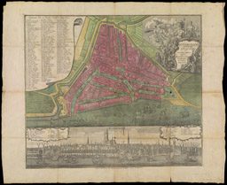
https://oshermaps.org/map/4732
Matthaus Seutter (1678-1756)
Roterdami delineation ichonographica et scenographica opera Matth. Seutter, geographi caesarei Aug. vind.
(Augsburg: Tobias Conrad Lotter, [1770]). 51x59cm.
Smith Collection
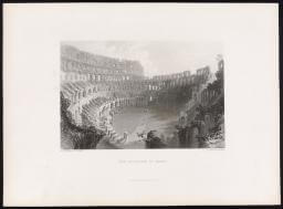
The Grand Tour had always been concerned with Italy’s classical heritage, so that the rediscovery in 1738 and 1749 of the Roman cities of Herculaneum and Pompeii drew tourists south to Naples. There they encountered stunning views of Mount Vesuvius, whose eruptions had destroyed the ancient towns. To keep the tourists, Naples constructed the world’s largest opera house, drawing talent from the city’s renowned music conservatories. Maps aided the tourist in accessing the Roman sites and in negotiating Naples’ labyrinth of streets. Italy remained a prominent destination for tourists into the nineteenth century. These three steel engravings of popular destinations are taken from a deluxe portfolio created in 1880 by a New York publishing house for consumption by upper middle-class Americans. The Appleton company catered to an audience that aspired to artistic refinement but expressed in a conventional academic style. The picturesque views and the accompanying text served a dual purpose for their readers, both inspiring the traveler while planning the trip and, once returned home, serving as an aide memoire in recalling the journey. The artists who executed these scenic views are now for the most part forgotten while their contemporaries, the French Impressionists, are still well known.
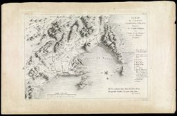
https://oshermaps.org/map/12987
Camillo Pellegrino
Carte de l’ancienne Campania felice dresse par Camillo Pellegrino extradite de son ouvrage sur les antiquit[ea] de Capone
([Rome], 1782). 28 x 39 cm.
OML Collection

https://oshermaps.org/map/3317
Perrier (fl. 1760-1824)
Plan de la Ville de Naples
([Paris], [1781?]). 27x41cm.
OML Collection

https://oshermaps.org/img/flat/tou13.jpg
W. Callow and R. Wallis.
The Bay of Naples: Early Morning. 18x26 cm.
Courtesy of Jerome and Monique Collins.
imhttps://oshermaps.org/g/flat/tou14.jpg
W. H. Bartlett and E. Challis.
The Coliseum at Rome. 18x26 cm.
Courtesy of Jerome and Monique Collins
https://oshermaps.org/img/flat/tou15.jpg
C. Stanfield and R. Wallis.
In the Gulf of Venice. 21x28 cm. New York: D. Appleton & Co., ca. 1880. C
Courtesy of Jerome and Monique Collins.
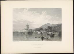
When the Grand Tour began, the passes through Switzerland’s mountains were a hazard to be negotiated in order to reach the all-important Italian cities such as Venice, Florence, Rome, and Naples. As in Coryat’s time, the crossing was arduous and dangerous. The paths were often too narrow for coaches, so these had to be dismantled and carried across piecemeal by donkeys and mules; the travelers themselves were carted in sedan chairs by porters. But the broad, paved roads constructed by Napoleon for his armies made it much easier to access the mountains. Changing sensibilities, and in particular a growing appreciation for the sublime, turned mountains from horror-inducing masses to aesthetically pleasing scenery. His friends were aghast when the English nature poet William Wordsworth walked the Simplon Pass in 1790, but on his return in 1820 to walk the Alpine passes with his family, he encountered many other Englishmen in village inns. Switzerland became a destination in its own right.
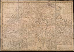
map/2https://oshermaps.org/033
Thomas Cadell (1773-1836)
Map of Switzerland marked with the routes of four tours in the years 1776, 1779, 1785 and 1786 by the Revd. Willm. Coxe.
(London, 1789) 52x76 cm.
Smith Collection
https://oshermaps.org/img/flat/tou17.jpg
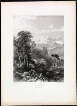
J.D. Harding and R. Wallis.
Val St. Nicola (Switzerland)
(New York: D. Appleton & Co., ca. 1880). 28x22 cm.
Courtesy of Jerome and Monique Collins.
https://oshermaps.org/map/2166
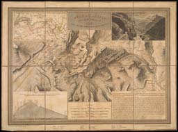
Aristide Michel Perrot (1753-1879)
Route de Simplon (Paris, 1824). 33x46 cm.
Smith Collection
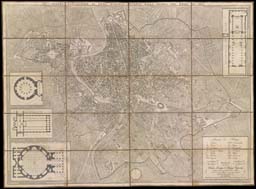
After a twenty-year hiatus during the Napoleonic wars, Britons eagerly resumed continental travel in 1815. Book dealers and map publishers were ready for a new generation of travelers seeking to recreate the Grand Tour with new, pocket-sized products designed for portability. Although city maps could still be purchased in the traditional sheet form, publishers now also made them available as segmented maps mounted on linen. Such maps could be unfolded and refolded repeatedly without damaging the paper. The examples shown here reveal wear and tear to the linen where it was creased but, for the most part, the maps are intact as witness to their durable design. Pictorial elements highlighting noteworthy attractions first appear on maps during this period. Other maps, while not specifically intended for travel, convey information about countries as well as basic geopolitical content. Disturnell’s map of Europe illustrates national currencies and flags. The scenic views depicted in its ten inset panels were most likely plagiarized from books by other geographers.

https://oshermaps.org/map/2142
Robert Laurie and James Whittle (fl. 1794-1858)
Laurie and Whittle’s New Map of London: with its environs, &c. including recent improvements
(London, 1818). 59 x 79 cm.
Smith Collection
https://oshermaps.org/map/4758
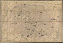
Alexandre Vuillemin (1812-1880)
Nouveau Plan Illustre de la ville de Paris avec le systeme complet de ses fortifications et forts detaches
(Paris: 1851). 57x87 cm.
Smith Collection
https://oshermaps.org/map/2163
Giambattista Nolli (1701-1756)
Nuova Planta di Roma Moderno estratta dalla grande del Nolli corretta ed accrescuita de nomi delle contrade indicate al loro rispettivo sito in Roma
(Rome: 1823). 61x82 cm.
Smith Collection

https://oshermaps.org/map/4766
John Disturnell (1801-1877)
Europe with part of Asia and Africa
(New York: 1840). 51x63 cm.
Story Collection