Long before mariners explored the Arctic, ancient geographers knew that higher latitudes were colder than lower ones. On this basis, they predicted that the equatorial regions were stiflingly hot and that the Polar Regions were frigidly cold [1-8], dividing the world into a series of climatic zones. At the top of this global layer cake, they placed the North Pole, an axis point which sat in the middle of a cold, featureless “Mare Glaciale.” [1-1] By the 1500s, however, ideas about polar geography began to change. In particular, the existence of a “Northwest Passage” above the American continent fired the imagination of Europeans, particularly in the British Isles. [1-2] [1-3] As Britain sought to find its own sea route to Asia, the Arctic carried the promise of commerce. In 1527, merchants Robert Thorne and Roger Barlow urged Henry VIII to send ships to find a northern passage to the Spice Islands, a route that would cut time and distance from the long voyage around Africa. [1-4] By the end of the sixteenth century, Britain had fielded a number of expeditions to find the Northwest Passage under the commands of Martin Frobisher, John Davis, Henry Hudson and others. Although little evidence supported the existence of such a passage, mapmakers remained optimistic, placing watery channels at the top of their maps of North America. [1-5] [1-6]
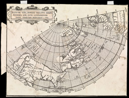
Michael Lok (publisher), England, dates unknown
Dedicated to the illustrious Sir Philip Sidney (Illustri Viro, Domino Phillipo Sidnaeo), 1582
engraving
Published forty-two years after Columbus’s discovery of America, Sebastian Münster’s map portrays the New World as an impressive continental barrier to the lands of Asia. Yet the map also shows points at which this barrier might be traversed: at the narrow isthmus between North and South America, at an isthmus further north at the Outer Banks, or, for the ambitious mariner, a thin channel above the American continent at the margins of the map.
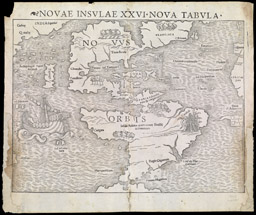
Sebastian Münster, Germany, 1488-1552
New Islands, the 26th New Map, New World (Novae Insulae XXVI Nova Tabula, novus orbis), 1545
engraving
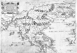
Bolognino Zaltieri, Italy, active 1555-1576
Drawing of the Discovery of New France (Il Disegno Del Discoperto Della Nova Franza), 1566
engraving
Barcode: 5638
Abraham Ortelius’s world map was part of a bound volume of maps titled Theatrum Orbis Terrarum, [Theater of the World], now considered the first world atlas. Extending through thirty-three editions and translated into six languages, Terrarum influenced European ideas about world geography in general, and ideas about the Arctic in particular. Note the clearly defined channel above the American continent running east-west, as well as a series of Arctic channels running north-south towards the North Pole.
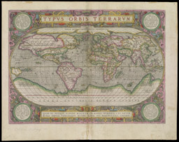
Abraham Ortelius, Belgium, 1527-1598
Map of the World (Typus orbis terrarium), 1612
hand-colored engraving
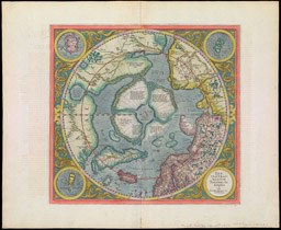
Gerhard Mercator (artist), Netherlands, 1512-1594
Jodocus Hondius (engraver?), Holland, 1563-1612
Map of the Northern Regions by Gerhard Mercator (Septentrionalium terrarum descripto per Gerardum Mercatorem cum privilegio), 1628-1633
hand-colored engraving
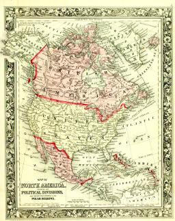
Wellington Williams (engraver), USA
Samuel Augustus Mitchell, Jr. (publisher), United States, 1792-1868
Map of North America showing its political divisions and recent discoveries in the polar regions, 1860
engraving
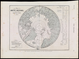
Illustrated Newspapers (publisher)
The Arctic Regions From the Admiralty Chart of 1875
engraving
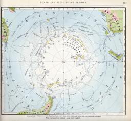
George F. Cram Company (publisher), USA, est. 1867
North Polar Regions with the principal routes of discovery
from Cram’s Unrivaled Atlas of the World, 1911
offset lithography in bound volume
Barcode: 3894

Jesse Olney (author), USA, 1798-1872
Robinson, Pratt & Co. (publisher), USA, est. 1835
The World on a Globular Projection
from A New and Improved School Atlas: To Accompany the Practical System of Modern Geography, 1837
hand colored engraving in bound volume
Barcode: 5302