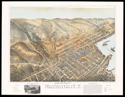
Bird's Eye View of Watkins, N.Y.
Printmaker: Bailey, Sarah F.Publisher: Bailey, Oakley HoopesFowler, Thaddeus MortimerLanguage: EnglishMap Type: Bird's-eye viewsGeographicalHistorical mapsDimensions: Map: 46.5 cm x 88 cm on sheet 58 x 76 cm
Printing Process: ChromolithographMaterial Type: PaperHistorical Context: "S.F. Bailey, fecit". Sarah Bailey, who was married to Oakley Hoopes Bailey, drafted this bird's eye view. She was one of a few female view artists active during the height of popularity of bird's eye views. "Published by Fowler & Bailey". Thaddeus Mortimer Fowler and Oakley Hoopes Bailey were partners until 1874. Bailey was a prolific American viewmaker, artist and lithographer active in the late 19th century and early 20th century. Fowler was an American cartographer and prolific city viewmakers. He and Bailey were partners from 1872 to 1874 but renewed their professional partnership in 1879. Fowler's main interest was Pennsylvania and views of the towns around the state. "Jones & Potsdamer, Lith. 321 Chestnut St. Phila." They were a Jewish Philadelphia lithographic firm active 1875-1885. Founded by Theodore Potsdamer and Alfred Jones, they mostly produced chromolithographic trade cards, advertising ephemera and letterpress work. Jones left the firm in 1875 and Potsdamer continued the business until 1885 when the Ketterlinus Company acquired it.
LC Call Number: G3804.W415 1879 B3
OCLC: 1483092319
Accession Number: OML-1879-63
![Folklore and legends of our country : [United States]](https://cdn1.historyit.com/iiif/2/5f34291499c4a6.60628694/67d9ce35ec5607.61169766.jpg/full/!400,400/0/default.jpg?no_errors=1)