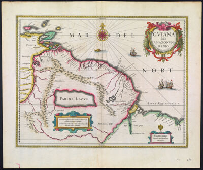
Gviana siue Amazonvm Regio
Creator: Hondius, Hendrik, 1597-1651Hondius, Hendrik, 1597-1651Atlas Reference: Hondius - Janssonius Atlas, English edition, 1636-41Publisher: Hondius, Hendrik, 1597-1651Hondius, Hendrik, 1597-1651Date/Date Range Produced: 1636
Language: EnglishLatinRegion Depicted: BrazilFrench GuianaGuyanaSouth AmericaSurinameTrinidad and TobagoVenezuelaMap Type: GeographicalPolitical mapsDimensions: 37 x 48 cm. on sheet 48 x 56 cm.
Printing Process: EngravingMaterial Type: PaperHistorical Context: This map is of particular interest for its depiction of the fictitious, large salt lake "Parime Lacus," with the legendary city of gold, "El Dorado," on its north-western shore. The descriptive text from the English edition of the Mercator-Hondius atlas in which this map appeared describes the topography and climate, the natives and their customs, and the fauna and flora. In the final paragraph of the text, the tale is told of a Spanish explorer who is said to have visited El Dorado.
LC Call Number: G5240 1636 .H6
OCLC: 826026508
Accession Number: OS-1636-2
Donor: Osher