Supporting Education and Instruction. OML is a leader in the movement to integrate old maps into K-12 (primary through high school) and university instruction. Over time, we have found that some maps resonate particularly well with students in visiting classes. Visually appealing and often related to familiar historical events, they hold students’ attention; clearly designed, they are readily interpreted by students. These maps are the “work horses” of our instruction.
Katherine Dudley’s 1928 map of Portland is one of these work horses (item 14). It serves as a wonderful introduction to the manner in which maps and views of cities construct a sense of place and community. Dudley was a member of the Baby Hygiene and Child Welfare Association in Portland, founded in 1919 as part of a national movement to improve public health programs for children. The map’s bright, fully saturated primary colors — in the manner of children’s book illustrations of the period — create a very specific image for Portland as a healthy place of clean water, open spaces, and fresh air. The vignettes around the margins summarize the city’s (equally sanitized) history.
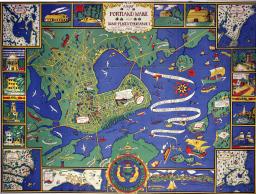
Katherine Dudley (fl.1920s)
A Map of Portland Maine and Some Places Thereabout (Boston: Tudor Press for the Portland Baby Hygiene & Child Welfare Association, 1928)
Color lithograph; 75 x 99cm
OML Collections (gift of John B. Krygier)