Making Maps Intellectually Accessible. To make proper sense of old maps, it is first necessary to understand the reasons why they were made and used. Although people often talk about “maps” in a generic way, as if all maps are alike, there are actually significant differences in maps based upon their various functions. As a result they cannot all be treated in the same way. A major task of our outreach is therefore to make these differences clear to the users of old maps.
The three maps in this section exemplify three basic kinds of map that entail different functions and different spatial conceptions: maps of property (item 34), maps of place (item 35), and maps of region (item 36). See Matthew H. Edney, “Mapping Parts of the World,” In Maps: Finding Our Place in the World, ed. James R. Akerman and Robert W. Karrow, Jr. (Chicago: University of Chicago Press, 2007), 117-57.
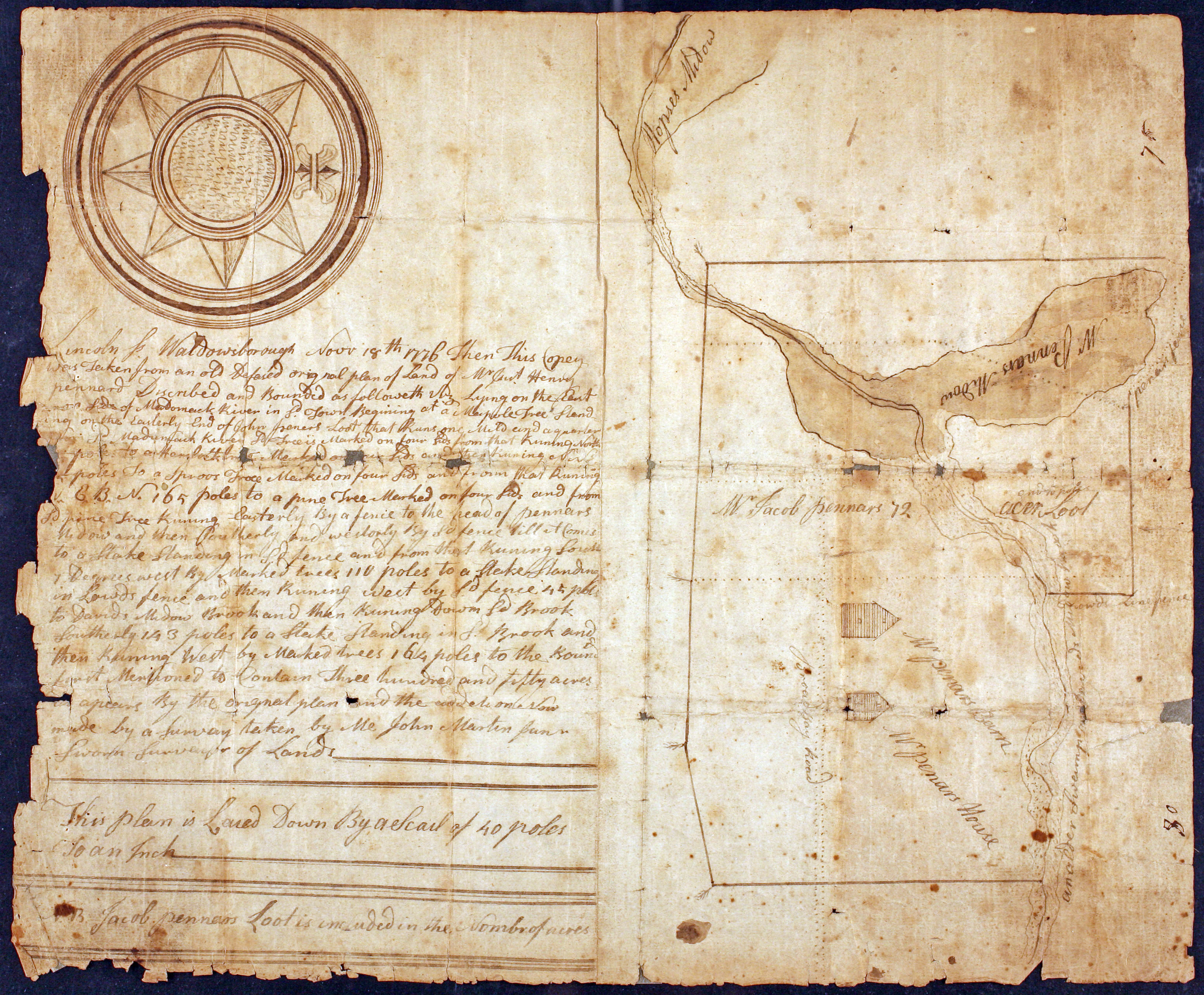
Maps of property — also known as plans or plats — represent a world fragmented into small, discrete parcels. They generally feature simple instruments and plane geometry (see items 7-11). They are made and used as part of the legal and archival processes of creating and maintaining property relations. In early America, they often functioned as illustrations of the legally binding “metes-and-bounds” description of the edges of a parcel of property (on the left-hand side here). So, while such documents are stored in large numbers in archives, any one particular map was rarely made in more than two or three copies (all manuscript). This example was made in 1776 to preserve “an old defaced” plan of Henry Pennard’s land.
John Martin, Junr.
“… This Copey was taken from an old defaced original plan of land of Mr. Henry Pennard …” (18 Nov. 1776)
Manuscript (ink) on paper; 31.5cm x 38cm
Osher Collection
Maps of place are made to give meaning to one locale so as to distinguish it from all others. Often depicting urban places (see item 14), such maps generally combine physical and human features of the landscape. Maps of rural places, like maps of property, are generally intended for a few, select users and so remain in manuscript form. This example was made as part of a literal act of place-creation. Alfred, Maine, was originally distinguished as the northern parish of Sanford in 1782, with its own meeting house, acquiring semi-autonomy as the District of Alfred in 1794. The district’s leading land owners, including William Parsons (father or son), worked to have the York County court house moved there. Their effort was successful, and Alfred became the county seat in 1802 and was itself incorporated in 1808. This map was prepared as part of this effort, to delimit Alfred’s core as a site of sufficiently dense settlement to be suitable for hosting the court house.
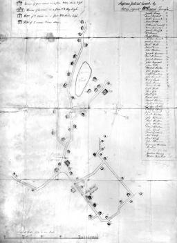
William Parsons (1743-1826 or 1780-1864)
“A Plan of that part of the District of Alfred within the vicinity of the Meeting house, taken for the purpose of shewing & proving the accommodations that can be had there, for holding a Supreme Judicial Court” (ca.1800)
Manuscript (black and red ink) on paper; 77cm x 49.5cm
Osher Collection
Maps of regions represent wide expanses of space, generally within networks of meridians and parallels that transform the spherical surface of the earth to flat paper. They are generally made by scholars who seek to organize knowledge about the world, whether dedicated academics (i.e., geographers) or historians, churchmen, statesmen, military officers, and so on. Maps of regions are the dominant kind of printed map, made for the use of a wide array of educated people interested in the world at large. Most of the maps in this exhibition are such maps. Regional maps are often included in books that discuss the nature, history, and state of the world. One of these is Adams’ small map of New England, designed as part of a general history of the region. A rare early imprint from a provincial Massachusetts town, this impression of the map was damaged when removed from the parent work.

Asher & Adams (1777-1860)
New England from Jedidiah Morse and Elijah Parish, A Compendious History of New England (Newburyport: Thomas & Whipple, 1809)
Copper engraving; 31.5cm x 20cm
Osher Collection