A. Ancient Greek Conceptions
After the Pythagoreans first argued, in the fifth century BCE, that the earth is a sphere, Greek philosophers sought to understand the nature of the globe. Unfortunately the Greeks’ own maps and globes have not survived and have been passed down to us only through late copies or reconstructions [items 1-2]. The Greeks divided the world into five broad zones, or klimata (“climates”), defined by their habitability: the “frigid” polar zones were too cold to support life; the “torrid” zone around the Equator was too hot; but between them lay two “temperate” zones where civilization could flourish [1]. While the Greeks knew and could map only the northern temperate zone, or oikumene (“known world”) [2], they argued that there had to be continents in the southern hemisphere to balance out the weight of the globe. Some argued that one or more “opposite” continents, or Antipodes, lay in the southern temperate zone. Aristotle, who also proved the earth’s sphericity in his De caelo (“On the heavens,” ca. 350 bce), imagined a stabilizing continent at the South Pole, which he called Antarktikos (“opposite the Arctic,” northern lands lying under the constellation of Arktos, the bear).
The oldest surviving images of the globe’s five zones are in medieval copies of works by the fifth-century Roman writer Macrobius, represented here in this early printed edition. This map shows one half (“hemisphere”) of the world divided by an equatorial ocean (Alveus Oceani) running around the torrid zone. The northern temperate zone contains the oikumene of Europe, Africa and Asia; the southern temperate zone is labeled temperata antipodum nobis incognita (“temperate southern lands unknown to us”). (In this global imagining, there would be two more continents on the further, hidden hemisphere.) However, in this model, the torrid zone formed an impassable barrier, so that the early Greek philosophers thought it impossible to ever reach the antipodes.

1. Aurelius Ambrosius Theodosius Macrobius
Zonal map of the world from the “Commentary on the Dream of Scipio”
Lugano: Sebastianum Gryphium, 1538
By the second century ce, when Claudius Ptolemy compiled his great gazetteer and instruction manual for how to make maps (Geographike Hyphegesis, or “Guide to Geography”) in Alexandria, Egypt, armies and traders had been crossing the torrid zone for centuries, disproving the ancient hypothesis. In his maps, Ptolemy accordingly extended the oikumene all the way to the Tropic of Capricorn (23º26’ south), well south of the Equator. Even so, he still regarded the Arctic Circle (66º34’ north) as the northern limit of habitality. (See in this map how he turned the northward extent of Scotland to the east to keep it within bounds!) By the 1460s, when Nicolaus Germanus edited Ptolemy’s work, he knew that the northern limit was also false; in his world map, shown here in a later printed version, he depicted Scandinavia and Greenland as breaking out of Ptolemy’s neat frame.
2. Nicolaus Germanus
World map
From: Claudius Ptolemy, Cosmographia (Ulm: Leinhard Holle, 1482)
Osher Collection, Osher Map Library, University of Southern Maine
B. The Renaissance Creation of Terra Australis
Luxury goods from Asia — textiles, spices, precious stones, perfumes, medicines, and glassware — were staggeringly expensive in fifteenth-century Europe because they had to pass overland through many middlemen. The Portuguese, then the Spaniards, English, French, and Dutch, all sought to cut out all the middlemen by sailing to Asia, whether southwards around Africa, directly westwards across the ocean, or northwards through the Arctic [section 2]. Their many voyages drastically changed Europe’s understanding of the world, not only by encountering the Americas but also by revealing the vast oceans of the southern hemisphere.
Although Europe’s mariners did not encounter the Antipodes or Antarctica, Europe’s geographers continued to believe in their existence. As the lands south of the Equator were revealed to be relatively limited in size, geographers conceptualized a very large terra australis (“southern continent”) just beyond the limits of navigation. The supposed southern lands feature prominently in the world maps exhibited here [items 3-5]. Their existence was given credence by Ferdinand Magellan’s circumnavigation in 1519–1522: prevented by vicious seas from rounding what we now call Cape Horn, he followed the strait (which now bears his name) between Patagonia and Tierra del Fuego to reach the Pacific Ocean. Not knowing that Tierra del Fuego is in fact an island, geographers took it to be the northernmost promontory of terra australis.
The French mathematician Oronce Fine prepared this map in 1531, using his remarkable cordiform (“heart-shaped”) projection, for one of the earliest compilations of travels and voyages of exploration. Referring to Magellan, Fine labels the southern continent Terra australis recenter invento sed nondu[m] plene cognita (“the newly discovered but not yet fully known southern land.” By sheer coincidence, Fine anticipated the size and shape of the continent that would eventually be revealed.

3. Oronce Fine
“Nova, et integra universi orbis description”
In: Johann Huttich and Simon Grynaeus, Orbis regionum ac insularum veteribus (Paris: Antoine Augurelle, 1532)
Abraham Ortelius first published his hugely successful Theatrum orbis terrarum, generally considered the first modern atlas, in 1570. The first of its seventy maps is of the world, with the southern lands labeled as Terra australis nondum cognita (“southern land not yet known”) but again with one promontory known: Tierra del Fuego.

4. Abraham Ortelius
“Typus orbis terrarum”
In: Theatrum orbis terrarum (Antwerp, 1574)
Rumold Mercator prepared this world map, for a modern edition of Strabo’s Geography (originally written in the first century bce), using information from his father Gerhard’s much larger 1569 world map (which had introduced the so-called “Mercator projection”). Rumold used a double-hemisphere projection [also item 8] to capture the sense of the world’s sphericity. In addition to the large terra australis, he copied his father’s delineation of a broad water passage through the Arctic Ocean that encouraged efforts to discover the Northwest and Northeast Passages to Asia [item 15 in section 2].
5. Rumold Mercator
“Orbis terrae compendiosa descriptio”
In: Isaac Casaubon, Strabonis rerum geographicarum libri XVII (Geneva, 1587)
C. Modeling the Earth as a Globe
Fifteenth-century scholars began to comprehend the entirety of Creation through both “terrestrial” globes of the earth and “celestial” globes of the heavens [item 12]. With printing, globes become very popular, although celestial globes all but disappeared after 1900 leaving the terrestrial globe to dominate [items 13-14]. Globes were printed as sets of “gores” that were cut out of the paper and pasted on a ball of plaster [item 6]. The set of gores shown here is one of the earliest to survive, from 1515, and was preserved because their author, Johannes Schöner (1477–1547), had used the paper for scrap within the binding of an atlas (or Sammelband) that he compiled from several important maps he had previously collected; the gores were discovered only after 1901 when the Schöner Sammelband was disassembled to allow those others maps, notably the only known copies of Martin Waldseemüller’s Universalis cosmographiae (1507) and Carta marina navigatoria (1516), to be photographed.
Depictions of terra australis were, of course, key to the geographical information on the globes themselves. Schöner also published a treatise on the globe, its content, and its use, entitled “A very clear description of the whole earth, with many useful cosmographic elements” [item 7]. Alas, Schöner did not explain why he depicted a narrow strait between South America and the supposed southern continent, which he labeled Brasilie regio [detail of item 6], several years before Magellan would chart the strait in 1520. We can only conjecture how he derived his information.
6a. Johannes Schöner
Gores for a terrestrial globe, 1515 ~ western hemisphere
Facsimile of the original in the Kislak Collection, Library of Congress, Washington, D.C.

6b. Johannes Schöner
Gores for a terrestrial globe, 1515 ~ eastern hemisphere
Facsimile of the original in the Kislak Collection, Library of Congress, Washington, D.C.
7. Johannes Schöner
“Orbis typus”
In: Luculentissima quaeda[m] terrae totius description (Nuremberg: Johannes Stuchs, 1515)
To capture the appearance of the globe on flat paper, geographers began to depict the earth in two hemispheres [also item 5]. The earliest known printed example of this approach was created by Francis Monachus, a Franciscan monk, in a small geographical treatise which is also one of the first to refer to terra australis, the “southern continent.”
8. Franciscus Monachus
World map in two hemispheres
In: De orbis situ ac descriptione (Antwerp, 1527)
Sir Francis Drake (1540?–1596) led the second successful circumnavigation in 1577–1580 [11]. Just after passing through the Straits of Magellan, in September 1578, his ship “The Golden Hind” was caught in a terrific storm that blew it far south into uncharted waters (now called the Drake Passage) where geographers had thought that terra australis should lie. The globe depicted in the 1583 portrait of Drake therefore omitted the supposed southern continent [12].
Geographers, however, remained committed to their long-standing conceptions. In 1602, Petrus Bertius also illustrated the giants of Patagonia, a mythical race first mentioned in Antonio Pigafetta’s chronicle of Magellan’s voyage; the note next to the illustration states that the giants can reach ten feet in height and that they paint their bodies in various colors derived from herbs [9]. In 1616, however, Jacob Le Maire (1585–1616) and Willem Corneliszoon Schouten (d. 1625) rounded Cape Horn and definitively cut terra australis off from Tierra del Fuego.
9. Petrus Bertius
“Fretum Magellanicum”
From: Tabularum geographicarum contractarum (Amsterdam, 1602)
10. Jodocus Hondius
Franciscus Draeck nobilissimus eques Angliae
[London], originally 1583, printed by George Vertue in eighteenth century

11. Philip Nichols
Sir Francis Drake Revived
London, 1626
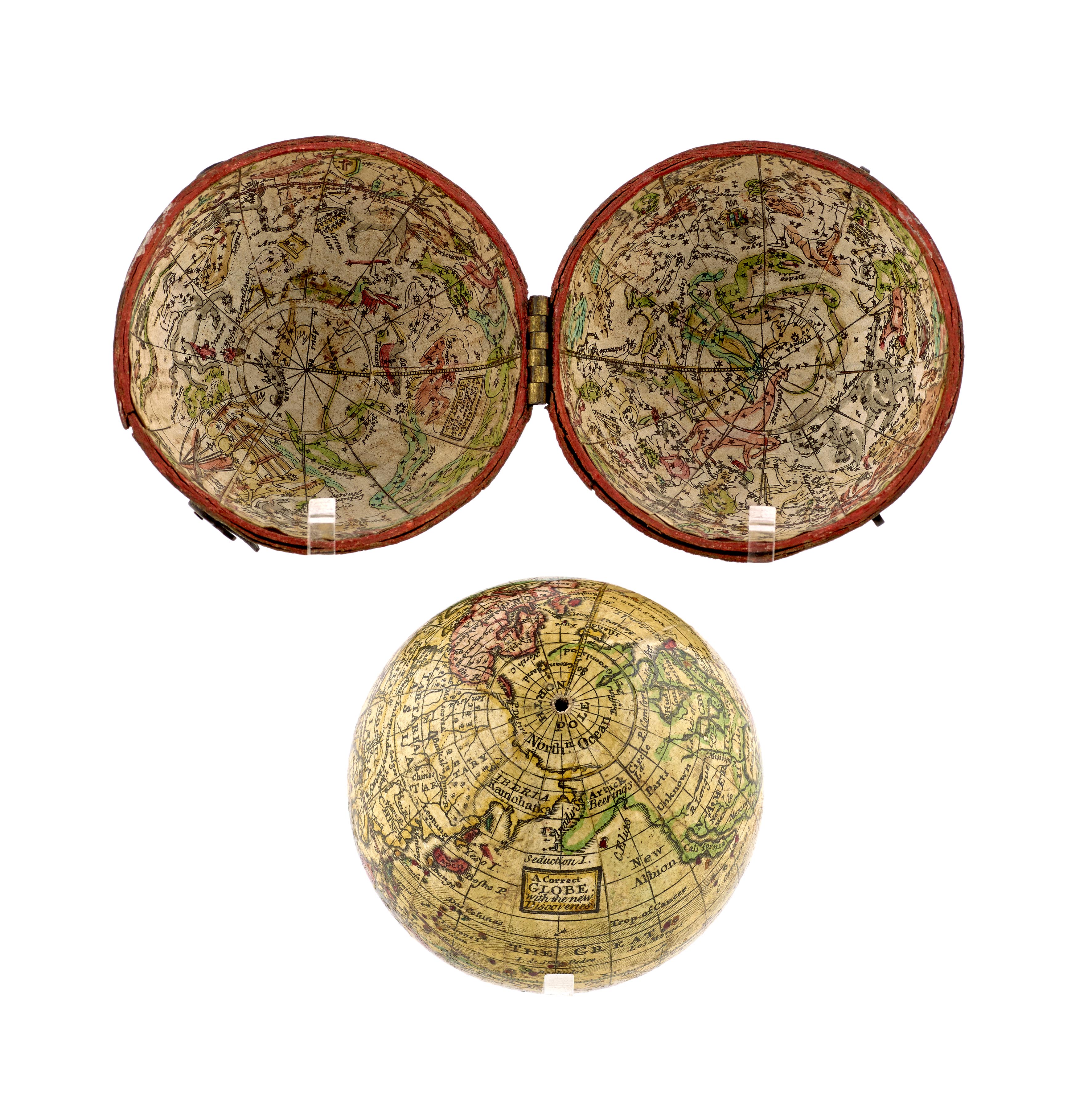
12. George Adams
A Correct Globe With New Discoveries / A Correct Globe with ye New Constellations of Dr Halley & Co
Terrestrial, 2¾-inch pocket globe with concave celestial globe in spherical case
[London], ca. 1785
13. J. G. Klinger
Terrestrial, 4cm pocket globe in wooden case
Nuremberg, ca. 1850

14. Ikelmer
Terrestrial, 8cm globe in 23cm stand
Paris, ca. 1890