

Women were full, if rarely acknowledged, participants in the map trade of the early modern period (1453-1789). They worked as colorists, engravers, printers, and publishers, producing hundreds of high quality cartographic items. Like other crafts in this era, the map trade was run as a unified family business: workshops and residences were housed in the same building, and each craftsman’s family lived with journeymen and apprentices. While it was still necessary and common for many women to disguise their gender by working under their initials, a few, such as Elizabeth Holt and Elizabeth Lowe, operated in their own right under their full names.
With the rise of large corporate map printing houses and the social constraints of the Victorian era women were pushed out of the map trade after 1800. It has only been in the last few decades that the extent of their contribution to the history of cartography had begun to be fully understood.
Coletta took over the business of her husband, Jodocus Hondius, for a short period after he died in 1612, before passing it on to their sons, Jodocus, Jr., and Henricus. She created this portrait a year after her husband’s death to honor him as well as the great cartographer Gerard Mercator, whose works formed the basis of Hondius’s stock. Mercator is widely known today for the rectangular world map projection found on so many classroom walls.
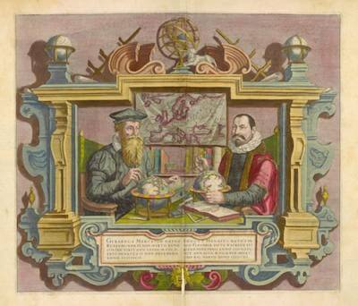
media/4969
Coletta (née Kaerius [van der Keere]) Hondius, engraver
[Portrait of Gerard Mercator and Jodocus Hondius]
Frontispiece in Gerhard Mercator and Jodocus Hondius, Gerardi Mercatoris et I. Hondii Atlas ou, Representation du monde universel, et des parties d’icelui faicte en tables et descriptions tresamples, et exactes (Amsterdam, 1633)
Facsimile of hand-colored copper engraving, 46 x 53 cm
Smith Collection
This hand-colored map of the Canadian Maritimes features a cartouche engraved and signed by Catherine Haussard. The design is conventional, with common symbols for North America: pine trees, a Native American canoe, and a beaver. The listing of hundreds of Native American villages in Canada provides an invaluable visual and historical record of tribal locations that would soon disappear from maps of the region.

map/690
Marie Catherine Haussard, engraver
Gilles Robert de Vaugondy, Partie de l’Amérique Septent. qui comprend la Nouvelle France ou le Canada, par le Sr. Robert de Vaugondy Géog. ordinaire du Roy. Avec privilege 1755.
From: Gilles Robert de Vaugondy, Atlas universel (Paris, 1757)
Hand-colored copper engraving, 47 x 60 cm
Osher Collection
In the larger firms of the eighteenth century, engravers specialized on creating particular elements of maps: lettering, borders, etc. Elizabeth engraved this map’s cartouche. The map was designed by Didier Robert de Vaugondy, someone else printed it, and another specialist colored it by hand. Complexity ruled. Elizabeth also worked with Jacques Bellin, and created the cartouche on his Carte Reduite des Isles Britanniques in his Hydrographie Francoise (1757).
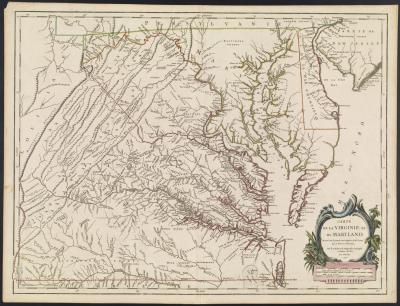
map/683
Elizabeth Haussard, engraver
From: Didier Robert de Vaugondy, Carte de la Virginie et du Maryland dressée sur la grande carte Angloise de Mrs. Josué Fry et Pierre Jefferson, par le Sr. Robert de Vaugondy Géographe ordinaire du Roi (Paris, 1755)
Gilles Robert and Didier Robert de Vaugondy, Atlas universel (Paris, 1757)
Hand-colored copper engraving, 48 x 64 cm
Osher Collection
The design of this double-hemisphere world map is typical of the era: its corners are filled with allegorical imagery symbolizing the four continents. Originally created for Nicolas Visscher’s Atlas contractus orbis terrarum, and sold separately as well, the map was also inserted within a 1663 edition of the Bible – Biblia, dat is, De gantsche Heylige Schrifture – published by Eva van Alphen Elzevir. She was the widow of Johan Elzevir of Leiden. After he died in 1661, Eva continued in business with their heirs. As a widow she retained rights to publishing for several years, notably early medical texts.
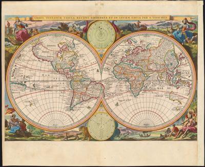
map/460
Anna van Alphen Elzevier, printer
Nicolas Visscher, Orbis terrarum tabula recens emendata et in lucem edita per N. Visscher (Amsterdam, 1663)
Hand-colored copper engraving, 32 x 50 cm
Osher Collection
Selina’s husband Sidney died in 1830, and she continued publishing his maps, sometimes revised, over several years, signed “S. Hall,” to take advantage of the marketing value of his reputation as a major map publisher of the early nineteenth century. Her maps appeared repeatedly, for example in Adam and Charles Black’s General Atlas (1841), in the New British Atlas (1836), in several editions of Travelling County Atlas (first in 1842), and in Samuel Butler’s Atlas of Ancient History (1871). Various cataloging records and biographical studies have overlooked Selina’s work and have consistently credited work by “S. Hall” to Sidney, even when produced long after his death.

map/14424
Selina Price Hall, publisher
Suffolk (London: Chapman & Hall, 1832)
Hand-colored copper engraving, 19 x 24 cm
Story Collection
Lithographed by Elizabeth Lenthall Stone from F. C. DeKrafft’s drawing. Earlier editions were by her husband, William James Stone, famous for his 1823 facsimile copper engraving of the Declaration of Independence. He most likely taught his wife her engraving skills. She was the daughter of John Lenthall, assistant architect for the Capitol building. She comments that her 1833 version of this map was a copy of a survey of the District of Columbia area by her uncles, Nicholas and Robert King.
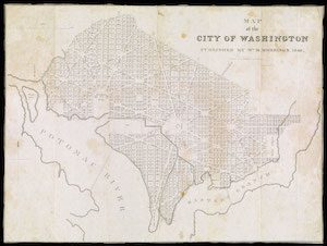
map/47418
Elizabeth Lenthall Stone, lithographer
F. C. DeKrafft, Map of the City of Washington (Washington, D.C., 1840)
Lithograph, 38 x 52 cm
Osher Collection
In 1788–1794, Elizabeth Holt published The Independent New-York Gazette, later called The New York Gazette, after her husband John’s death. The center portion of this supplement lists maps for sale from Elizabeth Holt’s publishing company, including Thomas Hutchins’ “Topographical description of Virginia, Pennsylvania, Maryland, and North-Carolina.” Reduced facsimile pages from the 1781 French edition have been provided for context.
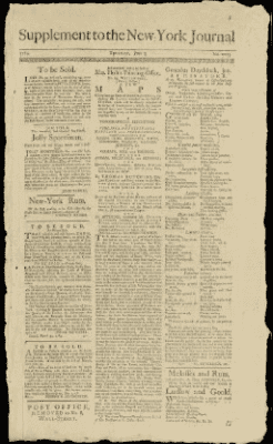
map/862
Supplement to New-York Journal, no. 2013 (June 2, 1785)
F. C. DeKrafft, Map of the City of Washington (Washington, D.C., 1840)
Letterpress, 36 x 19 cm
Osher Collection
This wondrous mini-map of the Netherlands, shaped as a lion and enhanced with gold leaf, appears in Jesuit historian Famiano Strada’s De bello Belgico, 1648. The map’s design derives from the lions featured on many Dutch coats of arms. At the bottom of the map, the imprint and privilege identified the publisher as Joannis Cnobbaert’s widow and successor in the business. She continued to publish for another twenty-five years, producing some 140 works, including further editions of De bello Belgico and the Office of the Blessed Virgin Marie (1650).

map/7373
Weduwe [widow of] Joannis Cnobbaert, publisher
Titlepage of Famianus Strada, De bello Belgico decas secanda (Antwerp, 1648)
Facsimile of hand-colored copper engraving, 28 x 16 cm
Osher Collection
#book-section-top{display:none;}
Widow of London printer George Lowe (fl. 1613–1616), Elizabeth maintained George’s status as member of the Merchant Taylors Company, which recognized her skills. Thus they allowed her in 1627 to apprentice Peter Stent for ten years under her direction. Lowe taught Stent the art of printing engravings and the elements of business practice. He became the most outstanding print publisher in London of his time, likely a result of his apprenticeship with Elizabeth Lowe. The Lowe house/shop was in Lothbury Street, one block from the Royal Exchange, guaranteeing a local market. The shop burned down in London’s Great Fire of 1666.
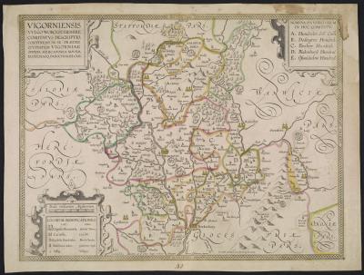
map/163
Elizabeth Lowe, publisher
Peter Stent, Vigorniensis vulgo Worcestershire comitatus descriptio, continens in se (praeter civitatem Vigorniae) oppida mercatoria novem ecclesiasq. parochiales CLII (London, 1680)
Hand-colored copper engraving, 36 x 47 cm
Miche Collection
Widow of Nicolas Visscher II, who died in 1702, Elizabeth continued his business until she sold her stock of copper plates to Peter Schenk in 1726. Schenk later revised and published this map of Flanders, in modern Belgium. A variety of maps appeared over the years with Elizabeth Verseyl’s name as publisher further qualified as weduwe or vidua (i.e., widow). She published several atlases, Atlas Minor (several editions to 1716), Atlas Major (ca. 1702), and De Stoel des Oorlogs in de wereld (after 1705, 1708).
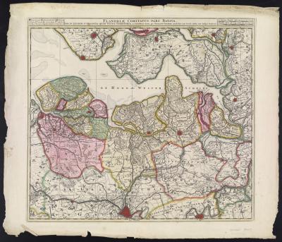
map/1847
Elizabeth Verseyl Visscher, publisher
Nicolas Visscher, Flandriae Comitatus pars Batava, tam in ejusdem sujacentia quam vicina territoria, accuratissima divisa per Nicolaum Visscher, Amst: Bat cum Privil: Ordin. Gen. Belgii Foederati (Amsterdam, after 1726)
Hand-colored copper engraving, 49 x 54 cm
Smith Collection
Following the death of her Huguenot husband, John Rocque, in 1762, Mary Ann Rocque administrated of his estate and continued his business for six years as the publisher of his works. She announced her status in the copyright statements on her maps – the phrase “published according to act” in the bottom margin – but because she used her initials, as on this map, her work has been laregely unrecognized as that of a woman in the map trade.
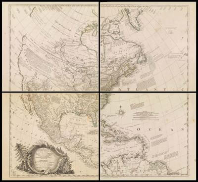
map/728.0003
Mary Ann Rocque, publisher
John Rocque, A General Map of North America; In which is Express’d the Several New Roads, Forts, Engagements, &c. taken from Actual Surveys and Observations Made in the Army employ’d there, from the Year 1754, to 1761. Drawn by the late John Rocque, Topographer to His Majesty (London: M. A. Rocque, 1761)
Copper engraving, 86 x 90 cm on four sheets, each 43 x 45 cm
Osher Collection
Daughter of a free Jamaican woman and a London barrister, Penelope inherited her chart dealer husband’s business and continued it for several years before selling it off to the Norie nautical chart firm. Selling nautical charts for the maritime audience was certainly not a recognized feminine role, and she was careful in most cases to sell her charts under her initial P. This particular chart, constructed with North to the right, shows the coasts of the counties of Kent, Essex, and Suffolk, and is especially concerned with the complex sand banks in the Thames estuary. The inset at top shows the winding Thames up to London and St. Paul’s cathedral.

map/47046
Penelope Steel, chart and bookseller
David Steel, The East Coast of England, from Folkstone to Hasborough Gat; Including All the Channels of the River Thames up to London (London, 1803)
Copper engraving in 2 sheets, 81 x 127 cm
OML Collections