In the nineteenth century, American schools paid great attention to teaching geography and there was a large market for new and improved versions of educational geographies, often written by women. Such work is represented here in Emma Willard’s The World as Known to the Ancients and Sarah Cornell’s The World in Two Hemispheres. Such works provide a unique resource for understanding the attitudes, ambitions, and priorities of America at a time of rapid change.
The pedagogic principle that children learn best by doing gained credence in the late 1700s and early 1800s. Some teachers had students learn their geography by copying maps from printed texts. Mary Hall’s map of the United States is compiled from a number of maps of individual states: starting in the northeast, she added states to the west and south, so that its spatial distortion progressively increases in those directions. These nineteenth-century works are contrasted against Anna Seile’s 1677 publication of Peter Heylyn’s Cosmography, which was an attempt to describe in meticulous detail every aspect of the known world including its geography, climate, customs, achievements, politics, and belief systems.
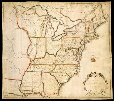
Emily Hill constructed this huge manuscript map from six linked sheets of paper. Geography was often taught to children by having them draw maps in order to learn about latitude, longitude, borders, and locations of places, but because of its size, it is likely the work of a teacher rather than a student. The map is derived from one of the many versions of Abraham Bradley's Map of the United States, Exhibiting the Post-Roads. Interestingly, it has mispellings: look for one in New England, and another near New York City. The map is decorated with a floral wreath design similar to those found in contemporary penmanship manuals from Vermont.
map/2398
Emily Hill
“A Map of the United States of America” (1820)
Manuscript, 100 x 114 cm
Osher Collection
This map was drawn by Mary Hall [Sayward], then a school girl in Alfred, York County, Me. The map was drawn about 1814, when she was 16, according to her grandson's memo accompanying this map when it was acquired.
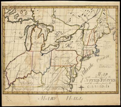
map/926
Mary Hall
“Map of the northern part of the United States and the southern part of the Canadas” (1814)
Manuscript, 36 x 47 cm
Osher Collection
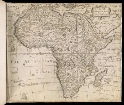
Anna Seile flourished in the London map trade for over a decade after her husband Henry's death, ca. 1662, working with a variety of partners. In order to make a living, she published numerous books on politics, religion, devotions, poetry, proverbs, and history, even Aesop's Fables. Among the constant sellers were general geographical textbooks, such as Heylyn's Cosmographie.
map/1770
Anna Seile, publisher
Africae nova descriptio Impensis Annae Seile. 1663
In Peter Heylyn, Cosmography in four books. Containing the chorography and history of the whole world: and all the principal kingdoms, provinces, seas and isles thereof … revised and corrected by the author himself immediately before his death (London, 1677)
Copper engraving, 33 x 40 cm, in 36cm-tall book
Smith Collection
Emma Willard was a respected pioneer in women's education in the U. S. In 1821 she founded the first academy for girls, the Troy Female Seminary, or Emma Willard School. Graduates from Troy went on to found women's colleges across America, offering ever more formal and professionally related curricula as the world of work became more open to women. She wrote many works that all appeared in multiple editions, such as Universal Geography, Geography for Beginners, Abridged History of the United States, and Astronography; or Astronomical Geography.
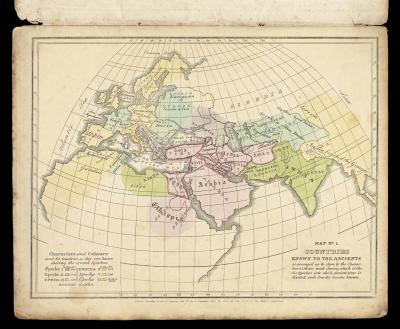
map/7514.0005
Emma Willard, author
Map No. 1. The World as Known to the Ancients
In William C. Woodbridge and Emma Willard, Ancient Atlas, to Accompany the Universal Geography (Hartford: Belknap and Hamersley, 1827)
Hand-colored copper engraving, 29 x 44
Osher Collection
Marinda Branson Moore wrote a series of works for grade schoolers, tailored to the children of the Confederacy. The first edition of her geography text was called Geography for Dixie Children. It contains maps only of the southern states, and has many comments critical of the United (i.e., northern) States, such as that they were now "tumbling into ruins, with the calamity brought about by Yankee injustice and avarice." Moore found most juvenile geography books too complex for young minds, so in her preface she states that "she made and effort to simplify the science of geography."
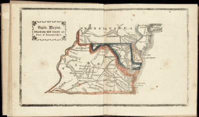
map/3357.0018c
Marinda Branson Moore
Virginia, Maryland, Delaware, New Jersey, and Part of Pennsylvania
In Marinda Branson Moore, Primary Geography, Arranged as a Reading Book for Common Schools, 2nd ed. (Raleigh, N.C.: Branson and Farrar, 1864)
Hand-colored lithograph, 16 x 28 cm
OML Collections
Sarah Cornell wrote many pedagogic texts, publishing under her initials rather than her full name. Her many atlases "were seen everywhere in [the nation's] little red schoolhouses," according to a piece of publisher's puffery on the back of one of her history texts. This double-hemisphere world map has a simple design so as not to overwhelm students with details. The questions at left are teaching tools, along with informative insets of world economic production, comparative mountain elevations (with smoky keys to volcanoes), and comparative river lengths.
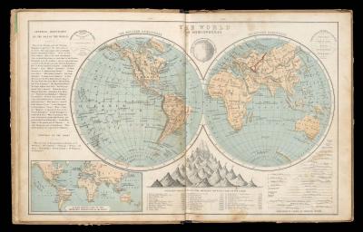
map/7782.0012c
Sarah Sophia Cornell
The World in Hemispheres
In: S. S. Cornell, Cornell’s Intermediate Geography: Forming Part Second of a Systematic Series of School Geographies, revised ed. (New York: D. Appleton & Co., 1869)
Hand-colored lithograph, 25 x 40 cm
Osher Collection
 View Exhibition Checklist