

After being excluded from more formal mapping activities from the turn of the 19th century, women artists participated prominently in the development of new markets for tourist and other pictorial maps beginning in the 1920’s. Pictorial maps depict places with an artistic rather than a technical aesthetic. Eschewing such conventional cartographic elements as scale and perspective, these maps depict historical events, legendary figures, local products, and monuments to define the character of each region. Their style varied according to shifting artistic tastes, from archly modernist Art Deco in the 1920s to plainer styles after 1945.
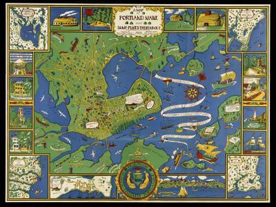
Katherine Dudley was a member of the Baby Hygiene and Child Welfare Association in Portland, founded in 1919 by local women as part of a national movement to improve public health programs for children. The association founded the Catherine Morrill Day Nursery, in 1920, the first in the city and still operating today. The map’s bright, fully saturated primary colors – in the manner of children’s book illustrations of the period – create a very specific image for Portland as a healthy place of clean water, open spaces, and fresh air. While ships dominate the bay – such as the Canceau, which led to the destruction of Falmouth Neck in 1775, and Captain John Smith’s boat from 1614 – trees dominate the landscapes on the map and its various enlarged insets. The vignettes around the margins summarize the city’s (equally sanitized) history.
map/37529
A Map of Portland Maine and Some Places Thereabout 1928 (Boston: The Tudor Press for the Portland Baby Hygiene and Child Welfare Association, 1928)
Color lithograph, 75 x 99 cm
OML Collections
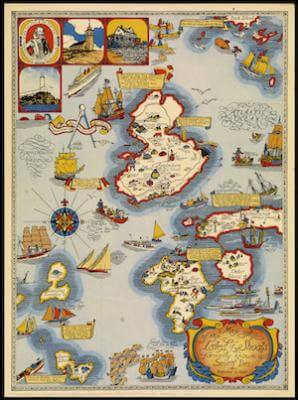
Named by the English explorer John Smith after himself, the islands were called the Isles of Shoals by early English settlers. The islands were eventually divided between New Hampshire and Maine, although the border, which runs between Star and Cedar islands, does not appear on this map. The map collapses the islands’ long history as fishing station, pirate refuge, tourist destination, and coast guard station into one ornate map of a distinctive place.
map/44308
Elizabeth Shurtleff
Map of the Isles of Shoals, formerly known as Smith’s Iles (Boston: Walker Lith. & Pub. Co., 1927)
Color lithograph, 68 x 50 cm
Moore Collection
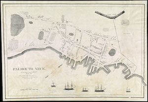
Burrage created her painting of the destruction of Falmouth Neck, now Portland, Maine, from a version of Willis’s map published in Portland in about 1850 by publishers Bailey & Noyes. Born in Portland, ME, Burrage is famous for her impressionistic art, based on her studies at the Wheeler School in Providence, R.I., and her years of art studies in Giverny, France, where she met Claude Monet and other impressionists.

Mildred Burrage
“Falmouth Neck As it was when destroyed by Mowatt, October 18, 1775”
Reduced facsimile of painted gesso map, 107 x 155 cm (original).
Courtesy of Maine Historical Society
View on Maine Memory
map/3568
Falmouth Neck, As it was when destroyed by Mowett, Oct. 18, 1775
From William Willis, The History of Portland, from its First Settlement: With Notices of the Neighbouring Towns, and of the Changes of Government in Maine, 2 vols. (Portland: Day, Fraser & Co., and Charles Day & Co., 1831–33), 2: opp. 156.
Reduced facsimile of lithograph by Pendleton’s Lithography, Boston, 41 x 60 cm (original)
Osher Collection
Known for her hand-drawn maps of Downeast and other Maine coastal and lake regions, mapmaker Jane Crosen is also a freelance editor and author of Maine Mapmaker’s Kitchen, a culinary round-the-world adventure.
A Maine native, Crosen studied art history and liberal arts at Brown University and Richmond College in London, England. At the Findhorn Community in Scotland she discovered publishing as a way to combine her skills with writing, editing, art, and design, working as graphic designer and editor with the Findhorn Press for several years. On returning to Maine, that experience led to a two-year post as in-house editor at DeLorme Publishing in Yarmouth, and then a move to WoodenBoat Publications in Brooklin, becoming the magazine’s copyeditor.
While at WoodenBoat she began making map illustrations, eventually self-publishing a series of some 30 maps, both monochrome and two-color, of Maine regions. For nearly 30 years she has combined self-publishing as a map artist with a parallel career as a freelance editor of recreational guides, cookbooks, and a wide range of practical non-fiction for Storey Publishing, Mountaineers Books, Lyons Press, and other publishers.
Crosen’s map items—posters, postcards, notecards, map T-shirts, chef aprons, and floursack towels—are available at stores throughout Maine, and at www.mainemapmaker.com.

exhibitions/women-in-cartography/section-two
Jane Crosen
Casco Bay and the Calendar Islands (1998)
Two-color Print, 40 x 50 cm
OML Collections
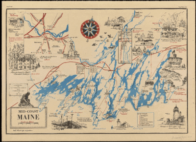
Ruth Lepper Gardner, a University of Southern Maine Distinguished Achievement Award honoree, was an artist and cartographer based in Southport, Maine. Born in Norwood, Massachusetts, she studied art at the School of the Museum of Fine Arts in Boston, and the New York School of Art. She was recruited during World War II to create maps at the Navy base in Newport, RI. She began creating pictorial maps of Maine’s coast, focusing on history, architecture and literature, in the 1950s.
map/11944
Ruth Rhoads Lepper [Gardner], cartographer & publisher
Mid-Coast Maine ([Brunswick, Me], 1979)
Color lithograph, 37 x 54 cm
OML Collections
In her map of the southern Maine coast, Lepper focused on the flora and fauna of the region and gave very accurate drawings of historic ships associated with the area. As she said, “when you live in a place where everybody knows boats, you have to draw them carefully.”

map/12113
Ruth Rhoads Lepper [Gardner], cartographer & publisher
The Maine Coast from Kittery to Cape Elizabeth (Southport, Me., 1977)
Color lithograph, 53 x 39 cm
OML Collections
Lepper populated her map of Casco Bay with ships built in Maine. The graphically dominant compass rose is a hallmark of the decorative, yet factual, maps that Ruth Rhodes Lepper made for tourists. The simple use of block color emphasizes the angular shape of the bay and its 200+ islands, formed by ancient glaciers.

map/12114
Ruth Rhoads Lepper [Gardner], cartographer & publisher
The Maine Coast: A Map of Casco Bay (West Southport, 1960)
Color lithograph, 53 x 39 cm
OML Collections
A fine example of the popular tourist maps made in the first half of twentieth century. This cool, clean, Art Deco design is populated by rabbits, roosters, chickens, turkeys, cattle, a moose or two, bears, deer, and fish. Fishing, lumber, quarry and tourist industries are highlighted. Native American history is respectfully presented. Henry David Thoreau’s visit in 1853 to Little Kineo Mtn., to the north, is noted, as is the 1789 purchase of one million acres of land by “General” William Bingham, of Pennsylvania, a weapons and munitions dealer, one of the richest men in America during the Revolutionary era.
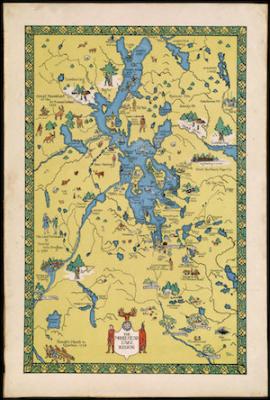
map/43635
Helen Prentiss Huckins
The Moosehead Lake Region (1931)
Color lithograph, 51 x 32 cm
OML Collections
Created by Ms. Brown for the Beacon Institute for Rivers and Estuaries, this map was also recently featured in the exhibition “Mapping New York’s Shoreline, 1609-2009: Celebrating the Quadricentennial of Henry Hudson’s Exploration of the Waterways of New York,” held at the New York Public Library in Manhattan. Colorful and pictorial in style, it is typical of Brown’s outstanding artwork and her focus on maps. In this case, educational supplements aimed at school youth add to its value.

exhibitions/women-in-cartography/section-two
Constance Brown
The Hudson River and its watershed (2007)
75 x 52 cm
Facsimile courtesy of the Leventhal Map Center at Boston Public Library