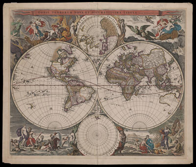
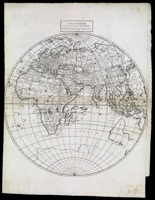
Orbis Terrarum Nova et Accuratissima Tabula. Auctore Nicolao Visscher
Creator: Visscher, Nicolaes, 1618-1679Publisher: Visscher, Nicolaes, 1618-1679Date/Date Range Produced: 1658
Language: LatinRegion Depicted: WorldMap Type: GeographicalPolitical mapsDimensions: 2 hemispheres 28 cm. in diameter on sheet 48 x 57 cm.
Printing Process: EngravingMaterial Type: PaperHistorical Context: The borders of this map are given over to allegorical representations of the four classical elements of the Greek universe (Cosmos): fire, air, water, and earth. At the upper left, fire is dramatically portrayed by a scene of Pluto abducting Proserpina in his chariot to his fiery underworld kingdom. At the upper right, air is represented by Jupiter and Juno in their chariot drawn over the clouds by eagles, with putti (winged cherubs) hovering about. At the lower left, water is personified by the sea-god Neptune and his wife, Amphitrite, in a seashell drawn by sea horses, and surrounded by Nereids (sea nymphs or mermaids) and Tritons (mermen). Earth, at the lower right, is represented by Ceres, the goddess of agriculture, wearing her characteristic crown of ears of corn and holding a cornucopia overflowing with fruit; vegetables and sheaves of grain lie on the ground and the scene connotes a pastoral thanksgiving.
OCLC: 23615754
Accession Number: OS-1658-4
Donor: OsherSubjects: AirAphrodite (Greek deity)Cherubs (Art)Demeter (Greek deity)FireFour elementsHades (Greek deity)Hera (Greek deity)Maps--Early works to 1800MythologyNeptune (Roman deity)Persephone (Greek deity)Pluto (Roman deity)Poseidon (Greek deity)Proserpina (Roman deity)Venus (Roman deity)Visscher, Nicolaes, 1618-1679World mapsZeus (Greek deity)