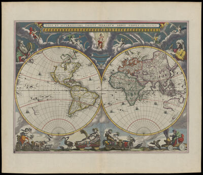
Nova et Accvratissima Totivs Terrarvm Orbis Tabvla. Auctore Ioanne Blaev.
Creator: Blaeu, Joan, 1596-1673Atlas Reference: Atlas MaiorPublisher: Blaeu, Joan, 1596-1673Date/Date Range Produced: 1662
Language: LatinRegion Depicted: WorldMap Type: GeographicalPolitical mapsDimensions: on sheet 57 x 64 cm.
Printing Process: EngravingMaterial Type: PaperHistorical Context: This map is considered one of the masterpieces of Dutch cartography owing to its excellent design and engraving. The top border depicts the heavens with an array of mythological gods reclining on clouds amid what appear to be numerous rainbows. In actuality, this is an allegorical representation of the solar system, with the sun represented by Apollo in a halo at the center, surrounded by the rainbow-like orbits of the known planets in their correct order: Mercury (with winged hat and caduceus), Venus (with love apple and Cupid), Mars (with helmet, shield, and sword), Jupiter (with crown, scepter, thunderbolt, and eagle), and Saturn (with scythe). The moon, represented by Luna (with crescent on her head), is seen in the cusp between the two hemispheres of the earth. At the bottom, the four seasons are represented by mythological figures in chariots drawn by animals and birds. From the left they are: spring, represented by Flora, goddess of flowers; summer, represented by Ceres, the goddess of agriculture; autumn, represented by Bacchus, the god of wine; and winter, represented by an old man warming himself against the chill of Boreas, the north wind. Joan Blaeu included this wonderfully ornate world map in the first volume of his eleven-volume Atlas Maior, published in Amsterdam in 1662. Blaeu derived the geographical content from earlier maps, probably one of the world maps by Nicolaas Visscher (Shirley 2001, no. 428). The projection showing the world in two hemispheres was also quite conventional; it was favored in the seventeenth century not only because it gave a sense of the earth's sphericity but also because it allowed a great deal of room in the margins for decorative elements. That decoration was, on this map, new and carried significant meaning.
LC Call Number: G3200 1662 .B6
OCLC: 13545833
Accession Number: OS-1662-3
Donor: Osher