24. Rand, Avery & Co., Map of the Eastern Railroad and principal connections, circa 1880.
Hamilton-Thayer Map Collection
www.oshermaps.org/map/52384
The Eastern Railroad published this map circa 1880 to promote its passenger service on routes out of Boston, to the seashores and summer resorts of northern New England. The thickest lines on the map represent routes operated by the Eastern Railroad, principally from Boston to Portland, Maine and North Conway, New Hampshire. To reach Portland, the Eastern had acquired Portland’s first railroad, the Portland, Saco and Portsmouth Railroad. The map covers all of New England and eastern Canada to show connecting railroads as well as steamship lines and remote areas served by stagecoach, all very helpful information for potential passengers planning summer vacations north of Boston.
This map advertises Pullman sleeping car service between Boston and Halifax. George Pullman designed the first practical sleeping car in 1865. The cars came into increased use on overnight trains in the 1870s.
The Eastern’s rival, the Boston and Maine Railroad, had built a competing line between Boston and Portland. In 1884, the Eastern was combined into the larger Boston and Maine system. Today, commuter trains use the former Eastern lines near Boston, and the Conway Scenic Railroad carries tourists from the Eastern’s Victorian depot in North Conway. Part of the Eastern’s line in Maine is now the Eastern Trail for bikers and hikers.
25. George H. Walker & Co., Birds-Eye from the Summit of Mt. Washington, White Mountains, New Hampshire, 1902.
Osher Map Library Sheet Map Collection.
www.oshermaps.org/map/40687
The Boston & Maine Railroad issued this unusual circular panoramic map in 1902 to promote tourist travel to New Hampshire’s White Mountains giving potential visitors a taste of the scenery they might glimpse during their rail travels. The colorful map shows a locomotive on the Mount Washington Cog Railway pushing a coach toward the summit of Mount Washington, the highest peak in the Northeastern United States. The Mount Washington Cog Railway, completed in 1869, is the world’s first cog railway, which uses a rack and pinion system to climb steep mountains. The railway, sometimes called the “railway to the moon,” is the second-steepest cog railway in the world. Still running today, the Mount Washington Cog Railway celebrates its 150th anniversary this year.
26. Boston and Maine Railroad, Summer Resorts of the Coast, Lake and Mountain Regions along the Boston & Maine Railroad and Connections, 1902.
Osher Map Library Sheet Map Collection.
www.oshermaps.org/map/40687
In an era before air conditioning, city dwellers in New York and Boston were eager to spend summer vacations at resorts in the coast, lake and mountain regions of northern New England. Grand resort hotels and rustic lodges catered to these travelers, and the train was the way to reach these destinations. An overnight ride on a sleeping car from New York City could bring a traveler to the White Mountains or the Maine coast. Or, one might ride a through Pullman parlor car from Boston to Farmington, Maine, and then transfer to the two-foot gauge Sandy River and Rangeley Lakes Railroad to reach the Rangeley Lakes region.
The Boston and Maine Railroad issued this map in 1909 to advertise the extent of its service in northern New England. At the time, the Boston and Maine also controlled the Maine Central Railroad. So, the map shows the routes of both railroads in thick red lines. Other connecting lines are shown in thinner red lines. An inset map highlights the White Mountains region of New Hampshire, the “American Switzerland,” where the Boston and Maine and the Maine Central had a particularly dense network of tracks.
27. Long Case—Ephemera, left
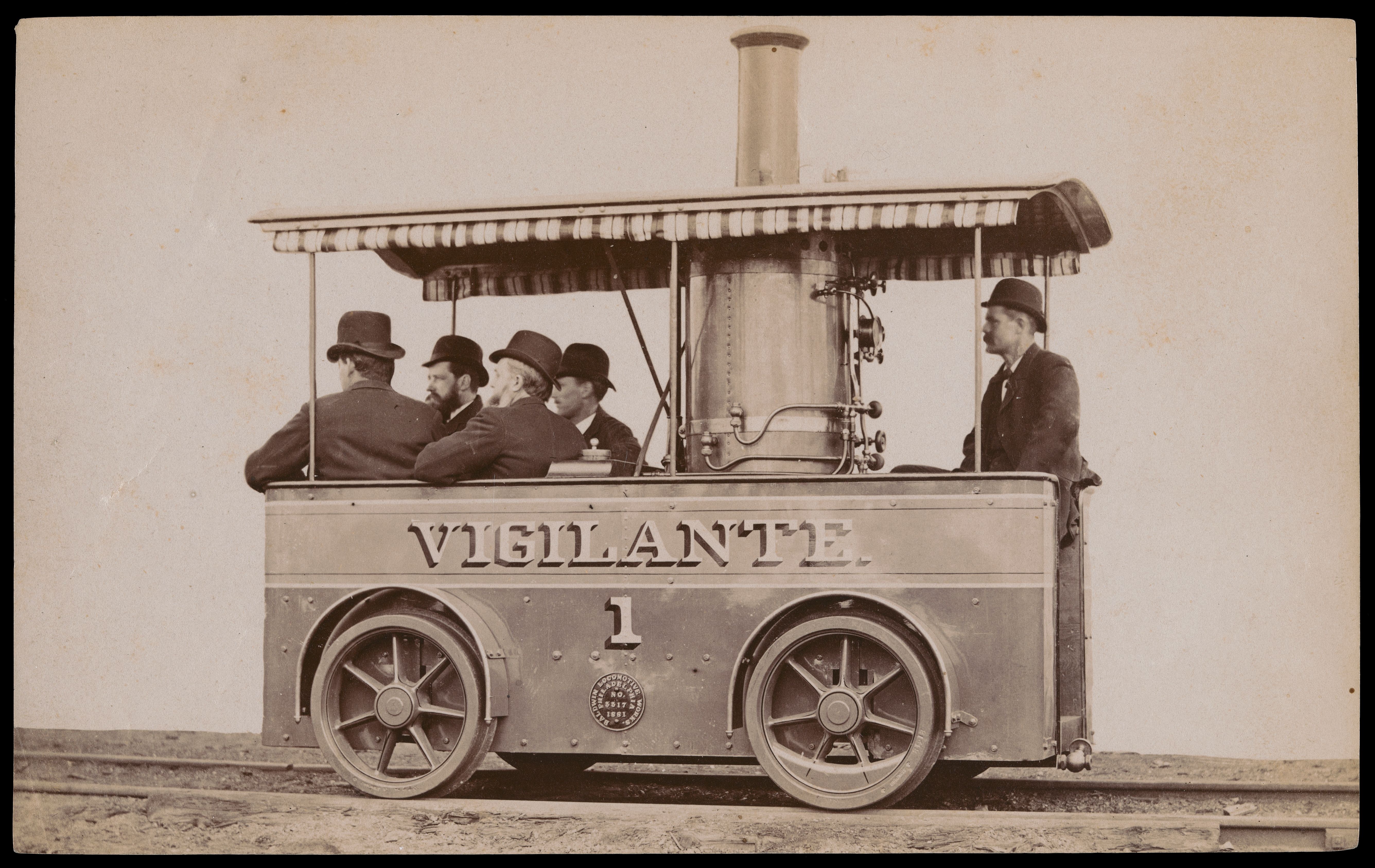
“Vigilante 1,” 1881.
Osher Map Library Ephemera Collection.
www.oshermaps.org/map/45163
The Bee Line, Compliments of the Season the Bee Line wishes you a Merry Christmas and a Happy New Year, 1882.
Freidman Ephemera Collection.
www.oshermaps.org/map/45258
Mt. Washington Railway. Summer Arrangement, 1871, 1871.
Osher Map Library Ephemera Collection
www.oshermaps.org/map/45096
Grant Locomotive Works: Gold Medal, 1867.
Osher Map Library Ephemera Collection.
www.oshermaps.org/map/45153
Colonial Express Washington Philadelphia and Boston, Pennsylvania R.R. and “Shore Line,” 1894.
Osher Map Library Ephemera Collection.
www.oshermaps.org/map/45095
First Annual Ball of the Brotherhood of Railway Trainmen, No. 745, 1908.
Osher Map Library Ephemera Collection.
www.oshermaps.org/map/45099
The Confederate Cabinet, courtesy of the Kennesaw Route.
Osher Map Library Ephemera Collection.
www.oshermaps.org/map/45206
On Arrival of Steamship Look Out for the Canadian Pacific Railway Passenger Agents. They will give you all information.
Osher Map Library Ephemera Collection.
www.oshermaps.org/map/45086
Digitized Item(s)
27. Long Case—Ephemera, right
Cassius “Kash” Marcellus Coolidge, Every Man Rides His Own Hobby.
Osher Map Library Ephemera Collection.
www.oshermaps.org/map/45081
Chicago Burlington & Quincy Railroad
Osher Map Library Ephemera Collection.
www.oshermaps.org/map/44991
The Great Trans-Continental Route.
Osher Map Library Ephemera Collection.
www.oshermaps.org/map/45085
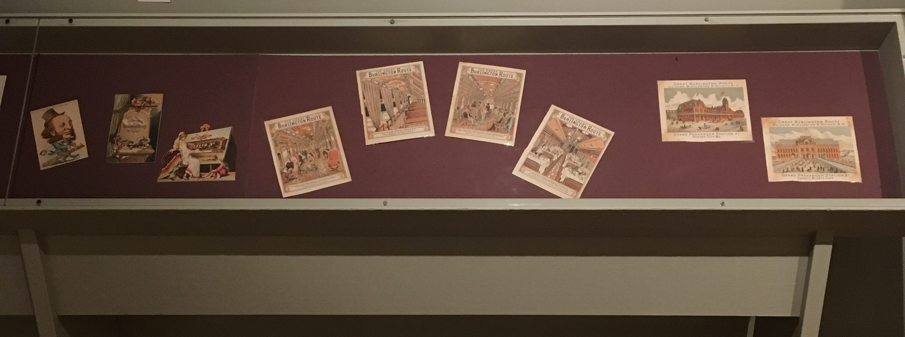
The Great Burlington Route: Interior View of one of the Elegant C., B. & Q. Parlor Cars…
Osher Map Library Ephemera Collection.
www.oshermaps.org/map/45114
The Great Burlington Route: Interior View of one of the Celebrated Pullman Sleeping Cars…
Osher Map Library Ephemera Collection.
www.oshermaps.org/map/45115
The Great Burlington Route: Interior View of one of the Luxurious C., B. & Q. Smoking Cars…
Osher Map Library Ephemera Collection.
www.oshermaps.org/map/45113
The Great Burlington Route: Interior View of one of the Famous Dining Cars…
Osher Map Library Ephemera Collection.
www.oshermaps.org/map/45112
Great Burlington Route Chicago, Burlington & Quincy R.R.: Grand Passenger Station at Kansas City, Mo. [AND] Grand Passenger Station at Atchison, Kansas.
Osher Map Library Ephemera Collection.
www.oshermaps.org/map/45118
Great Burlington Route Chicago, Burlington & Quincy R.R. Grand Passenger Station at Council Bluffs, Iowa.
Osher Map Library Ephemera Collection.
www.oshermaps.org/map/45111
28. John Wesley Powell, Map of the United States Exhibiting the Grants of Land Made by the General Government to Aid in the Construction of Railroads and Wagon Roads, 1878.
Osher Sheet Map Collection.
www.oshermaps.org/map/1162
The first railroads in the United States were built in New England and other parts of the Northeast where there were existing towns and industries which gave the railroads the prospect of immediate profits. In the American West, potential railroad profits depended on the hope for future development. The Federal government desired railroad expansion to promote the more rapid settlement of the West and to link California with the Union, often at the expense of Native American Tribes inhabiting the land. Between 1850 and 1872, the U.S. granted federal land to provide sufficient financial incentive for railroads to build in the West. As a railroad built a mile of track, it would receive a strip of land between 20 and 50 miles wide, as shown on this map. The railroad received only half the land in this strip. The railroad earned alternate square-mile sections in a checkerboard fashion. The railroad could sell its land or use it as collateral for loans to further construction. The railroad’s construction subsequently raised the value of the alternate sections of land which remained in the government’s hands. The best-known line supported by land grants was the first transcontinental railroad consisting of the Union Pacific and Central Pacific Railroads completed 150 years ago on May 10, 1869. This line appears on the map as the central route between Nebraska and Sacramento, California.
This map’s heading indicates it is “To Accompany Report on the Lands of the Arid Region of the U.S.” by John Wesley Powell whose name appears at the bottom right. Powell, after losing one arm in the Civil War, led explorations of the Rocky Mountains, including an epic journey by boat on the Colorado River through the Grand Canyon, also in 1869. In the 1870s, railroads were selling their land grant acreage for agricultural development which would yield freight traffic. From 1881 to 1894, Powell served as the second director of the United States Geological Survey where he promoted more accurate mapping of the West.
29. F.W. Cummings, Del. & J.H. Buffords, Lith., Freight Engine: “State of Maine,”. Portland Cos. Works, Portland, Maine, 1851.
On loan from the collections of Dr. Walter Goldfarb
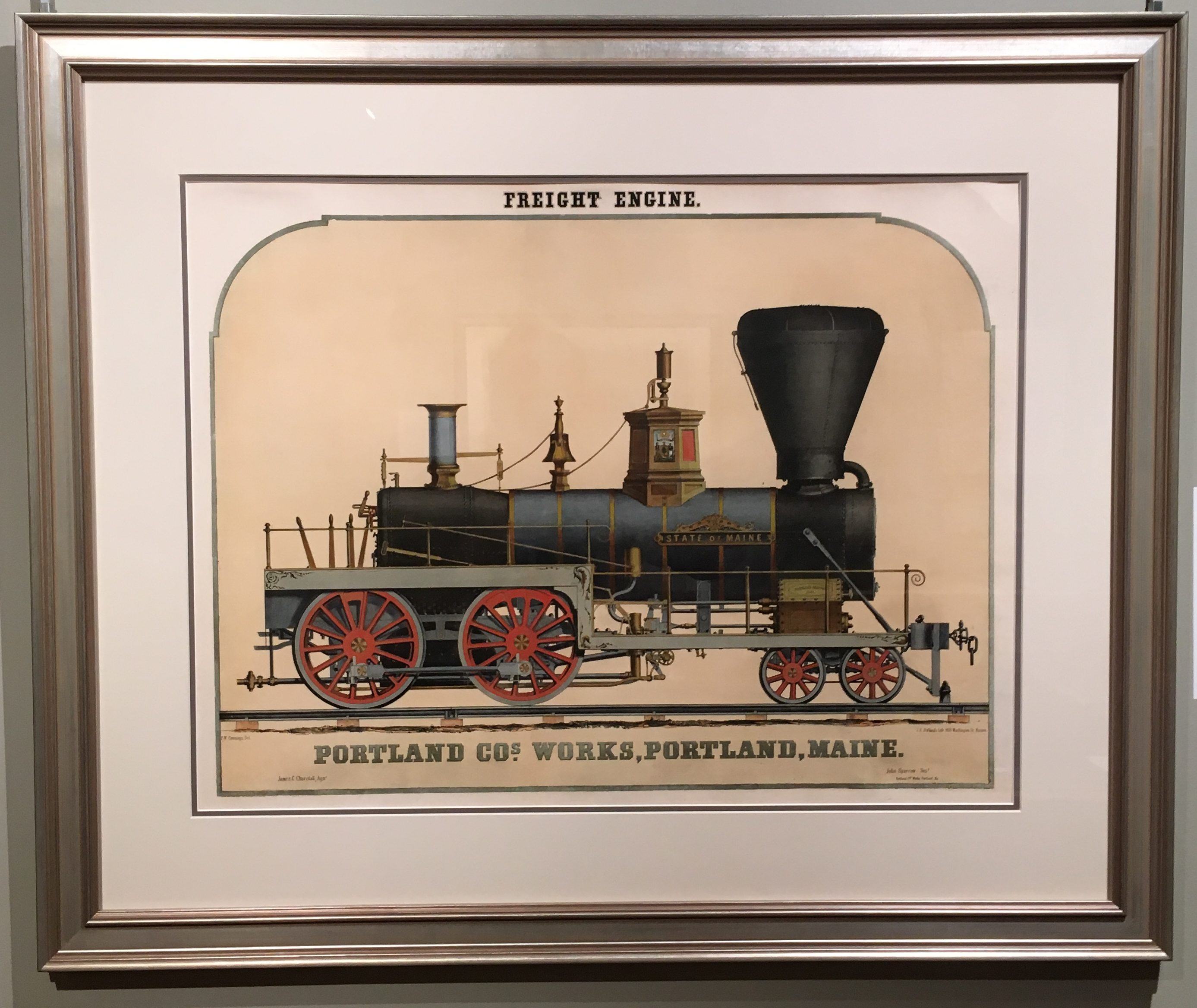
The Portland Company was established on November 10, 1846, by John A. Poor and engineer Septimus Norris of Norris Locomotive Works in Portland, Maine. The company was established as a locomotive foundry and became one of the leading medium-to-heavy steel manufacturers in New England. Located on the waterfront in Portland’s East End, from 1848 to about 1978, the company produced over 600 steam locomotives as well as 160 merchant and naval vessels. These carefully and beautifully rendered lithographs of freight and passenger engines depict the elegant design and superior craftsmanship the company was known for.