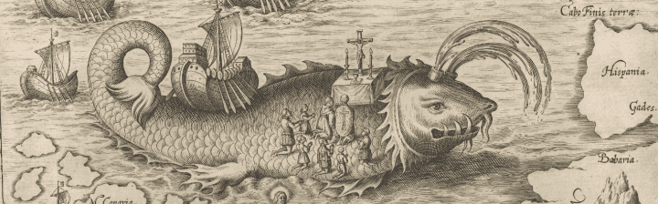
The voyage of Saint Brendan around 570 CE served to continue the tradition of folklore surrounding the Arctic that began with the travels of Pytheas of Massalia in 320 BCE. In the more than 100 manuscript accounts of Saint Brendan’s travels, he is said to have ventured west from the Kerry coast into the North Atlantic in a skin-covered boat, encountering “great demons [that] threw down lumps of fiery slag from an island with rivers of gold fire”, “great crystal pillars,” and “coagulated seas,” likely a reference to pack ice and icebergs around Iceland. He is also said to have held Mass on the back of a whale.
1. Caspar Plautius, [Illustration describing a portion of Saint Brendan’s voyage] from Nova Typis Transacta Navigatio (1621).
Osher Collection
URL: www.oshermaps.org/map/7361.0038
Ramusio’s map of the Western Hemisphere was the first commercially available map to accurately depict the Americas. While this map is crucial for understanding the advancement of mapping the Americas, it reveals the lack of knowledge about the Northern parts of the Hemisphere. In the east, the oceans end abruptly above Terra del Laborador; in the west, they stop at the “Sierra Neuadas” in what is now California. The depiction of the Strait of Magellan in the south and the inclusion of speculative geographic details near the then unknown southern continent would serve to inspire explorers to fill in the missing northern portions of the map.
2.Giovanni Ramusio & Giacomo Gastaldi, Universale Della Parte del Mondo Nuovamente Ritrovata (1565).
Osher Collection
URL: www.oshermaps.org/map/279
The first modern description of the Zeno family’s travels in the New World appeared in a 1558 travel book describing a pre-Columbian (1380) voyage to the Americas by Venetians, Nicolo and Antonio Zeno. The map was later copied in 1561 by Ruscelli for his edition of Claudius Ptolemy’s Geographia, introducing the map and legend to a significantly broader audience.
Most historians regard the map and accompanying narrative as a hoax perpetrated by the Zeno descendants to make a retroactive claim on the discovery of the New World for Venice. The evidence against the authenticity of the map is based largely on the appearance of many non-existent islands in the North Atlantic, including the mythical island of Frisland, where the Zeno brothers allegedly spent some time.
These fictional islands and places occasionally appeared on maps for centuries, mainly because Gerard Mercator accepted the Zeno voyage account as authentic, adopting its described geography in his famous 1569 world map and his 1595 map of the North Pole. Ortelius, in turn, used Mercator’s map as a prototype for his map of the North Atlantic. Zeno’s map and account was so widely accepted that even explorers Frobisher and Davis used the map on their expeditions in the 1570s and 1580s, respectively. The story fell into dormancy in the 17th century, but was revived by Forster and Buache in the late 18th century. The Hakluyt Society published an English translation in 1873, and in 1883 Baron Nordenskiöld argued in favor of the validity of the narrative. Finally, in 1898, Frederick Lucas concluded that the story to be a hoax after an extensive study in which he identified the geographic sources of the Zeno map to be Olaus Magnus’ Carta Marina and some other 15th and 16th century maps.
3. Niccolo Zeno, Carta de Navegar de Nicolo et Antonio Zeni Furono in Tramontana Lano MCCCLXXX (1558).
Osher Collection
URL: www.oshermaps.org/map/279
This rare and finely engraved map, originally issued by Paolo Forlani, is the first printed map to portray North America separately from South America and the first to show the so-called “Strait of Anian” partitioning North America from Asia at the approximate location of the Bering Strait. This depiction of a strait between the continents would bolster the idea of a Northwest Passage for centuries.
This map uses geographic information from Giacomo Gastaldi’s world map of 1565 (Item 2). Gastaldi had been the first to formulate the concept of the Strait of Anian, probably named after the Chinese province of Ania that was mentioned in a 1559 edition of The Travels of Marco Polo. This map’s inclusion of Gastaldi’s theorized Strait of Anian, a concept that persisted well into the 18th century, makes this a cornerstone work in the mapping of North America.
4. Bolognino Zaltieri, Il Disegno del Discoperto della Nova Franza (1566).
Smith Collection
URL: www.oshermaps.org/map/279
Sir Humphrey Gilbert was one of the leading advocates for the existence of a navigable Northwest Passage to Cathay (present-day China.) Gilbert made an elaborate case to counter the calls for the development of a northeastern route through Russia. This included creating a map showing the geographic certainty of a Northwest Passage. His map was derived from an Abraham Ortelius map and published by George Gascoigne. He also argued for a voyage through the Northwest Passage before Queen Elizabeth I, noting that Columbus had discovered America with far less evidence, and that it was imperative for England to catch up to the Iberian powers in the settlement of new lands. Gilbert’s contentions won support and money was raised, chiefly by the London merchant Michael Lok. The fearless Martin Frobisher was appointed leader of the voyage and left England in search of the Northwest Passage in June 1576.
5. Sir Humphrey Gilbert, A General Map, Made Onelye for the Particuler Declaration of this Discovery (1576).
Osher Collection
URL: www.oshermaps.org/map/307
Michael Lok, an English merchant and traveller, was the principal backer of Sir Martin Frobisher’s voyages in search of the Northwest Passage, supplying many of the necessities at his own cost. Even though Frobisher’s voyages were a failure, Lok still promoted the existence of the Northwest Passage, producing this map for Richard Hakluyt’s Divers Voyages in 1582. This map was widely distributed and trumpeted the voyages of Frobisher and Sebastian Cabot, prominently displaying the years of their discoveries. The message of Lok’s map is one of clear nationalism, presenting English claims over a large landmass through sovereignty and possession based on precedent of first discovery.
6. Michael Lok, Illustri Viro, Domino Phillippo Sidnaeo Michael Lok Civis Londinensis Hanc Chartam Dedicabat (1582).
Osher Collection
URL: www.oshermaps.org/map/316
7. George Best & James Beare, [Untitled map of Arctic and Northwest Passage] (1578).
Osher Collection
URL: www.oshermaps.org/map/309
In 1576 Martin Frobisher, licensed by Elizabeth I and backed by a group of merchant adventurers, including Michael Lok, sought gold in the New World and a Northwest Passage to the Cathay (present-day China). George Best accompanied Frobisher on all of his three voyages (in 1576, 1577 and 1578) and these maps are the first visual accounts of them. James Beare, Frobisher’s principal surveyor, drew both maps. The rough outline of Western Europe, “Groenland,” and “the supposed fyrmeland of America” wrongly convinced many people in England that the Northwest Passage had actually been discovered. Frobisher succeeded in discovering the Hudson Strait (which he named Mistaken Strait) and returned from his first voyage with accounts of newly discovered lands and a few stones from Hall’s Island. One of these stones, upon being assayed, was reported to contain gold. Frobisher’s voyages and claim to have found gold became the talk of Europe, even sparking a visit to England from Abraham Ortelius in 1577. On Frobisher’s next two voyages, he brought back 200 and 1,350 tons of rock, eventually determined to be iron pyrite and mica. These rocks ended up serving as road building material in the county of Kent. One of the ships that Frobisher lost on his first voyage contained timbers for a new colony, which would have been the first English settlement in the New World, had the supplies survived the journey.
8. George Best, [Untitled Oval Map of the World] (1578).
Osher Collection
URL: www.oshermaps.org/map/308
De Jode’s rare, seminal work is the first folio-sized atlas map to focus on North America. The map contains many remarkably early cartographic details, including a very linear representation of a double Northwest Passage running the length of the top of the map. The map is filled with annotations regarding early explorations in the New World, referencing Verazano, Cabot, Raleigh, and other explorers; an early mention of the Apaches is also present. Shown near the Northwest Passage is the early mythical great lake, Lac Conibas, which made an earlier appearance on Wytfliet’s 1597 map. To the right of the title is a scene illustrating the attack on Frobisher’s vessel by American Indians. Although his map was vastly superior to Ortelius’ map of the Americas, De Jode’s atlas sold poorly, accounting for the rarity of this work.
9. Cornelius de Jode, Americae Pars Borealis, Florida, Baccalaos, Canada, Corterealis (1593).
Smith Collection
URL: www.oshermaps.org/map/1666
This is the final state of Champlain’s 1616 map of northeastern North America. Champlain himself never issued the map, except in a single extant proof copy currently held by the John Carter Brown Library; it was not until Pierre Duval acquired the plate in the early 1650s that the map appeared in print. The map depicts a network of Great Lakes based on American Indian accounts and Champlain’s travels in the region from 1603 to 1615. Three lakes appear in rudimentary form: “Lac St. Louis,” “Mer douce ou gande Lac des Hurons,” and “Lac des Tuanst.”
The appearance of an open-ended waterway at the map’s western border and the notation alluding to a possible link to a western sea support the prospect of water routes to the Pacific. Additionally, a possible Northwest Passage route is shown winding its way through Hudson Strait and Buttons Bay, labelled “Route tenue l’an 1665 pour aller au Iapon et a la Chine.” British colonies are shown in both New England and Virginia, divided by the Dutch colony of New Holland.
10. Samuel de Champlain, Le Canada (1677).
Smith Collection
URL: www.oshermaps.org/map/1772


