The existence of Bowen’s 1823 plan of Portland (Section 3) might have prompted other local entrepreneurs to consider publishing detailed directories of Portland’s inhabitants and businesses. Certainly, such a directory would have been in keeping with the city’s atmosphere of continued growth and its new status as state capital. And, in fact, the first directories ~ with maps ~ both appeared within the same year, published by Abijah Thayer and Nathaniel Jewett. The properties of both directories were later acquired by other publishers and continually updated in a long sequence of directories published into the 1860s and beyond.
This second part of the description of the booster genre of urban mapping focuses on the maps included in the directories. The bibliography contains a full list of the directories issued through 1860, together with links to digital copies provided online by the Osher Map Library through USM’s Digital Commons.
The pragmatic circumstances of the survival of the directories and their maps mean that it is very hard to be precise about each state of a printing plate. The directories were all well used. Their maps ~ whether bound opposite the title page or at the very end of a directory ~ have often fallen out or been taken out for separate use or separate sale (sometimes illicitly). Surviving copies of both the books and the maps are thus few and far between and they are often in bad shape! Copies of the directories exist without the map, and vice versa; maps still in the directories are often in such desperately poor shape that they cannot be used. For these reasons, the following account, including the indication and dating of variants, must be considered tentative.
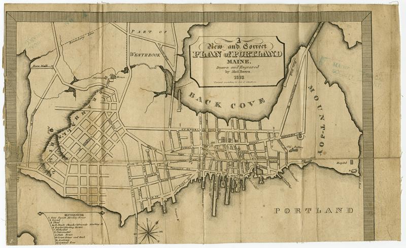
Abijah Thayer (1823, [2]) recorded the fact that he had copyrighted, on 1 September 1823, the title of his planned work, Portland Directory … together with a Map of the Town. With hindsight, it is clear that this map would have been Bowen’s New and Correct Plan. Thayer had taken this unusual step ~ to copyright a title rather than a completed work ~ in a failed effort to protect his idea of a directory. Thayer had hired Nathanial Jewett to collect the necessary information for his directory, but they had fallen out over payment and Jewett set about preparing his own Portland Directory & Register. In a major blow to Thayer, it was Jewett’s publishers who bought the copper plate for Bowen’s map. After publication of the directories, Jewett and Thayer continued to trade insults in the newspapers ~ setting aside the issue of who had the right to the map, they now addressed each other’s lack of character ~ until a libel suit ended in a hung jury (Independent Statesman 3, no. 20 [22 Nov 1823]: 3; Eastern Argus 21, no. 1083 [2 Dec 1823]: 3; Independent Statesman 3, no. 22 [6 Dec 1823]: 3; and Eastern Argus 21, no. 1112 [22 June 1824]: 2).
The two directories were both first advertised in October 1823 ~ Thayer’s in his own newspaper (Independent Statesman 3, no. 14 [11 Oct 1823]), Jewett’s in the Eastern Argus (21, no. 1078 [28 Oct 1823]: 3) ~ and were then both published in November (Thayer 1823; Jewett 1823). Both directories listed the heads of households by last name, identifying their professions and the streets on which they lived; both included separate lists identifying “people of color.” Their main point of difference lay in how they presented Portland’s space.
Thayer was “disappointed in what he considered his just expectation of procuring the Plate” for Bowen’s map of the city (Thayer 1823, [3]). Instead, he provided a list of Portland’s streets, and the streets they ran between, that would assist in the location of the businesses and individuals listed in the directory. In advertisements for the published work, Thayer described this “accurate Description of all the Streets and Wharves” as being “from recent survey,” as if it were a map itself (Eastern Argus 21, no. 1081 [18 Nov 1823]: 3). Importantly, in complaining about the lack of a map in the published work, Thayer confirmed that the intended consumers for the directory were local Portlanders.
Jewett’s directory included the graphic map:

[Map 2.2. Abel Bowen, A New and Correct Plan of Portland Maine. Drawn and Engraved by Abel Bowen. 1823. Entered According to Act of Congress ([Portland], 1823). Variant 2. Issued in Jewett (1823, frontispiece). This is the best quality surviving impression, albeit without the bottom portion (either trimmed or torn away); one can nonetheless see the newly added bridge. Copper engraving, 23 x 28 cm. Maine Historical Society, Portland. Directory MX P837.1 QJ 1823. Click on map for high-resolution image.]
Jewett, or his publishers, had some small changes made to Bowen’s map. The last line of the title was changed from “Population 9000” to the copyright statement, “Entered according to Act of Congress”; the new Portland Bridge across the Fore River, construction of which began in 1823, was inserted between the compass rose and the scroll of references; and it was printed on smaller paper so that it could be more easily folded within the pocket-sized directory, albeit with tighter margins. But otherwise no change was made in the map’s representation of Portland’s character.
The next directory appeared in 1827, sold by the Portland bookseller James Adams Jr. (advertised for sale by Adams in the Portland Advertiser 4, no. 38 [13 March 1827]). This directory contained a new map, engraved in Portland by David G. Johnson.
[Map 4.1. David G. Johnson, A Plan of Portland, Engraved for the Directory. By D. G. Johnson, 1827. Variant 1. Issued in Directory (1827). Copper engraving, 23.5 x 28 cm. Courtesy Harvard Map Collection, Harvard University. G3734 P8 1827 J6. Click on map for high-resolution image.]
Johnson had arrived in Portland in December 1824. In 1825, he engraved the plates for Lemuel Moody’s chart of Portland Harbor (see Section 1; OML OS-1819-9 contains several receipts for Moody’s payments to Johnson for engraving the chart). Johnson left Portland in mid-1827 having received, as he put it, “but slender encouragement” from the people of Portland (Shettleworth 1971, 105–8, quoting Johnson’s advert in the Eastern Argus [5 April 1827]). His plan of Portland was perhaps the last work he accomplished in the city. Stauffer (1907, 142) described Johnson as “a painter and line-engraver of portraits and views of little merit, who was working in New York in 1831–35, and again in 1845.” Johnson would work with the Colton firm in New York, producing, for example, a large wall map of the world: Colton’s Illustrated & Embellished Steel Plate Map of the World on Mercator’s Projection, “compiled, drawn, & engraved by D. G. Johnson” (New York: J. H. Colton, 1854).
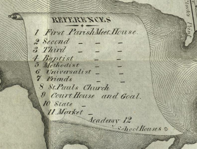
Johnson’s map was about the same size as Bowen’s map and adhered to its symbolic conventions: the spatial frame; the large, prominent title placed in the Back Cove; a compass rose, without indication of magnetic variation, set just off the wharves; and the list of “references” on a scroll in the Fore River:

[Detail of Map 4.1.]
Johnson’s choice of buildings and institutions to identify by number was more selective, yet similar to Bowen’s: 1–8, churches; 9–12, civic institutions (court house and jail, state house, market, and academy); and a circle, with a dot, for schoolhouses. And Johnson added a new element to the conventions of representing Portland: he shaded the extent of the built-up area, distinguishing between the legal extent of the town and the urbs, but also making clear how much room the city had for future enlargement.
The copper plate for Johnson’s plan of Portland was retained by the publisher after he left the city, and it was reused for the next directory. Dated 1831, this directory was actually published by S. Colman in late 1830 (Eastern Argus 7, no. 628 [10 Dec 1830]: 4). As Johnson was no longer involved in updating the image, the work is should no longer be attributed to him directly.
[Map 4.2. A Plan of Portland, Engraved for the Directory. By D. G. Johnson. 1831. Variant 2. Issued in Directory (1831). Copper engraving. Osher Map Library and Smith Center for Cartographic Education, University of Southern Maine. OS-1831-16 (separate copy). Click on map for high-resolution image.]
The shading of the built-up portion of the town was extended slightly so as to encompass the ropewalk on the shore of the Back Cove, by Deering Bridge. (The shading would not thereafter be extended in further states of the map). Two other features were added: a short road from Washington Street down to the Back Cove and, more noticeably, the line of the berm that enclosed the Cumberland & Oxford Canal along the edge of the Fore River.

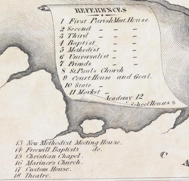
[Detail of Map 4.2.]
And six features were added to the list of references: 13–16 for four more churches; 17 for the customs house; and 18 for the theatre. With no space available in the existing scroll, the new references were placed on the shore of Cape Elizabeth. These features maintained the civic-moral emphasis of the map, and the inclusion of the theatre could perhaps be taken as a boast that the city had finally grown big enough to sustain such cultural endeavors.
The printer Arthur Shirley acquired the Portland directory and reissued it in 1834. The map was again updated, with a new date and the addition of one new reference (no. 19, “High Street Meeting House”). Moreover, color was now applied by hand ~ all surviving impressions seen have the color ~ to demarcate voting wards established as a result of Portland’s incorporation as a city in 1832 (Anon. 1980, 177), complete with its own governing council.
[Map 4.3. A Plan of Portland, Engraved for the Directory. By D. G. Johnson. 1834. Variant 3. Issued in Directory (1834). Copper engraving. Osher Map Library and Smith Center for Cartographic Education, University of Southern Maine. OS-1834-6. Click on map for high-resolution image. (Another copy, although in poorer condition)]
Shirley produced new directories in 1837 (Directory 1837) and 1841, the latter with a new attribution to one Harlowe Harris (Harris 1841); the property was then acquired by Brown Thurston and reprinted in 1844 (Harris 1844). It might be expected that Johnson’s map would again be included in these editions of the directory. However, none of the copies of the three directories that have been examined (USM, MHS, PPL, AAS, MSL) contain a map; nor have loose impressions been recorded bearing any of the three dates. While such maps might be revealed in the future, contemporary circumstances would seem to preclude the possibility: 1837–44 was a period of deep economic recession and it is probable that the extra cost of a map was simply avoided by the publishers.
In the post-recession 1846 directory, now attributed to Sylvester Breakmore Beckett (1812–1882), Thurston once again included a map printed from an updated state of the copper plate for Johnson’s map. The map was now ostensibly credited to the Portland bookseller and sometime engraver and printer Samuel Hodgson Colesworthy (b. 1808); Colesworthy likely was involved in preparing and printing the plate, but cannot be given full authority for the map. A key change in this, and subsequent uses of the map, is that it was no longer colored.
[Map 4.4. A Plan of Portland, Engraved as a Directory. Pub. by S. H. Colesworthy. 1846. Variant 4. Issued in Beckett (1846). David Rumsey Collection. 4457002. Click on map for high-resolution image.]
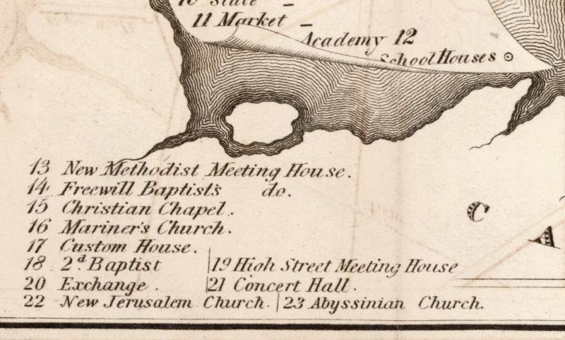
The most noticeable change to the plate was in the title, where Johnson’s name was replaced by Colesworthy’s. Furthermore, four more references (nos. 20–23) were added to the list in Cape Elizabeth: New Custom House; Concert Hall; New Jerusalem Church; and Abyssinian Church. The space was already full, so the map’s inner neatline had to be removed to fit the new references:

[Detail of Map 4.4.]
The inclusion of a specific reference to the Abyssinian Church is suggestive. It had been constructed in 1828–1831 as the first meeting house for Portland’s African-American community. While it had already been depicted on John Cullum’s grand map of 1836 (see section 5), this was the first time it had been shown in this sequence of maps in the Portland directories. The delay in its depiction possibly indicates the status of African-Americans in Maine at the time: it is worth remembering that although Maine had entered the Union in 1820 as a free state, one of the first actions of its new legislature had been to prohibit African Americans from entering the state.
Other content changes in map 4.4 include new streets being laid out on Munjoy Hill, including the (eastern) Promenade, and, on Bramhall Hill, the (western) Promenade and Western Cemetery; more names along the waterfront of the harbor; a railroad bridge cutting out into Fore River, running behind the main scroll of references, and terminating in a new pier labeled “RR Wharf” and “Depot.”
[Map 4.5. A Plan of Portland, Engraved as a Directory. Pub. by S. H. Colesworthy. 1847. Variant 5. Issued in Beckett (1847). Osher Map Library and Smith Center for Cartographic Education, University of Southern Maine. OS-1847-3. Click on map for high-resolution image.]
For the next edition of the directory (Beckett 1847), the map was further edited: the date was changed to “1847” in the title; some more streets added or labeled on either hill, such as “Briggs St.” just off Danforth St., and also in the center of town, such as Stone St., running from Cumberland down to the Back Cove; and jetties on either side of the Fore River were added and labeled “Steam Ferry.”
[Map 4.6. A Plan of Portland, Engraved as a Directory. Pub. by S. H. Colesworthy. 1850. Variant 6. Issued in Beckett (1850). Osher Map Library and Smith Center for Cartographic Education, University of Southern Maine. OS-1850-2. Click on map for high-resolution image.]
The key change in the plan for the 1850 directory (Beckett 1850) was the marking of the reclaimed land in the back Cove for a new railway depot, together with causeways and routes for the York and Cumberland and Kennebec and Portland Rail Roads. The shading for the city’s built-up area had not been modified since 1831 (above) and can no longer be taken as representative of the extent of the city’s urban area.
[Map 4.7. A Plan of Portland, Engraved as a Directory. Pub. by S. H. Colesworthy. 1852. Variant 7. Issued in Beckett (1852). Osher Map Library and Smith Center for Cartographic Education, University of Southern Maine. OML-1852-5. Click on map for high-resolution image. (Another copy is available for consultation.)]
In the 1852 directory, the city’s growth continues apace. More streets are indicated on both hills. A new causeway for the Atlantic and St. Lawrence Rail Road cuts across the head of the wharfs along the Fore River before swinging around Munjoy Hill and heading up the coast. And of course the date has been changed.
[Map 4.8. A Plan of Portland, Engraved as a Directory. Pub. by S. H. Colesworthy. 1856. Variant 8. Issued in Beckett (1856). Osher Map Library and Smith Center for Cartographic Education, University of Southern Maine. OML-1856-1. Click on map for high-resolution image.]
There appears to be very few alterations to the map in the 1856 directory (Beckett 1856), other than the date change in the title. The lack of change is suggestive the age of the plate and the difficulty of keeping it up to date. Perhaps the plate was starting to wear (the impression is weak in the impressions examined). Whatever the reason, this eighth variant of Johnson’s map was apparently the last to be printed, and the directory’s publisher, Brown Thurston, used a different map for his next directory (Beckett 1858; see map 13 in section 7).
Cite this Page
Edney, Matthew H., with the assistance of Jordan Lessard. “Booster Maps in Directories for a Growing City.” Section 4 of “References to the Fore! Local Boosters, Historians, and Engineers Map Antebellum Portland, Maine.” www.oshermaps.org/special-map-exhibit/references-to-the-fore. Published online, 1 July 2017.