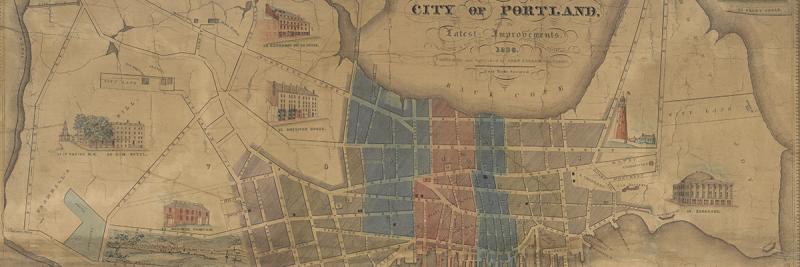

Cities are naturally cartogenic and even a small and young urban place like the colonial port-village that would become antebellum Portland left numerous cartographic traces. Such early traces generally show the location of an urban place within a region, or a very particular part of the urban place. Such maps do not capture the sense of the city ~ here, Portland ~ as a place. They might indicate a sense of Portland’s urbs, but not its civitas.
Settlement in colonial New England was mostly rural, dispersed, and organized in a series of “towns.” Each town was the territorial expression of the meeting, the joint religious and political institution of a community. As each town’s population grew and dispersed within the town’s limits, new meetings were established and took portions of the parent town’s territory for themselves (Zuckerman 1970; Martin 1991; Wood 1997, esp. 43–51). John Small indicated this process on his 1761 map of the district of Maine:
[Southwestern sheet of John Small, “… this map of the Countys of York, Cumberland & Lincoln” (Scarborough, 1761). Manuscript, 38 x 49 cm (sheet only). Osher Map Library and Smith Center for Cartographic Education, University of Southern Maine. OS-1761-10.3. Click on map for high-resolution image.]
Small depicted the early division of the “eastern district” of Massachusetts into agricultural towns, each distinguished by its boundary, its name, and the approximate location(s) of its meeting house(s). Some of the interior towns mapped by Small were still too new to have an established meeting. The English population along the coast, however, had been growing since resettlement of the region began in 1700, with the end of the Indian wars. As a result, Small mapped two meetinghouses within each of the towns of Berwick, Kittery, York, Biddeford, and Scarborough, and three in Falmouth. Eventually, the new meetings would break away as the core of new, smaller towns that are closer to their present-day forms. In the case of Falmouth, two of the meetings would eventually split off to form Cape Elizabeth, in 1775, and Portland, in 1786 (Anon. 1980, 138, 177).
Settlement within each town was mostly dispersed. The nucleated New England village centered on a green and meetinghouse, so celebrated in popular culture over the last two centuries, is actually a creation of the nineteenth-century industrial era (Wood 1997). But a few nucleated settlements did develop within the sea of New England’s dispersed colonial settlement. All were located at coastal and river sites that offered good harbors for trade. Boston, Salem, Newport, and New Haven were among the first to develop. Too small to be called “cities,” calling them “towns” confuses them with their parent communities; a good term for these nucleated settlements is therefore “urban places.”
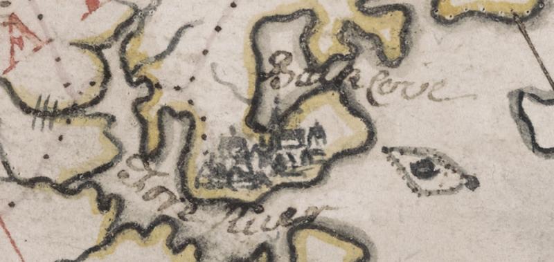
In his 1761 map, Small identified two of these nucleated, urban places: Portsmouth, N.H., on the southwest shore of the Piscataqua River, and an unnamed settlement on a neck of land within the town of Falmouth:

[Detail of Small, “… this map of the Countys of York, Cumberland & Lincoln” (1761).]
This bundle of houses, clustered around a meetinghouse and facing the Fore River, contrasts strongly with the depiction of other colonial settlement in Maine, all represented by solitary meeting houses. What was important to Small ~ and to the conventions for regional mapping that had developed in colonial New England ~ was the nucleatedness of the place, which is to say its character as urbs; its internal structure was not important. Nor did Small give this proto-Portland a name: it was simply a densely settled part of the town of Falmouth. He did, however, name the water bodies on either side of the neck: Fore River and Back Cove.
The relationship of the nucleated settlement on the Machegonne peninsula to the river and harbor was captured during Samuel Holland’s mapping of the Maine coast in 1771–1773, as part of his survey of the coast of New England (Hornsby 2011, 72–85). A map of the harbor at Falmouth, which is to say the southwestern portion of Casco Bay, was published along with the rest of Holland’s work in J. F. W. Des Barres’ Atlantic Neptune (1776):
[Detail from the untitled map of “Falmouth Harbour” from Samuel Holland’s survey. First published in the Atlantic Neptune (London: J. F. W. Des Barres, 1776), this is the 1781 variant, showing relief. A neat manuscript version of this map by Charles Blaskowitz, dated 1777, is British Library Add. MS 16,367 f. Copper engraving with hand-applied watercolor. Osher Map Library and Smith Center for Cartographic Education, University of Southern Maine. OS-1781-4. Click on map for high-resolution image.]
Holland’s map encompassed the Machegonne peninsula, revealing how the neck was then almost an island and how the nucleated port-village had swollen to cover one side of a swale between two hills. The shading of the “built up” area of the urbs is too neat: as the dots indicating individual buildings indicate, the village was not consistently built over and included much open land. The road running along the ridge of the swale and then down towards a ferry that connected to the rest of the town of Falmouth is modern Congress Street. Wharves already jut out into the sheltered harbor provided by Fore River. But all this internal urban information is ancillary to the map’s marine ethos.
A variety of private, local, and governmental charts of the harbor were produced during the early nineteenth century. They similarly treat the city with little precision, given that their focus was on the water, the coastline, and the harbor itself. Local mariner turned entrepreneur Lemuel Moody (1767–1846), for example, generalized the city and even the wharves in his 1825 chart of Casco Bay:
[Detail of the inset of “Portland Harbour” on Lemuel Moody, Chart of Portland Harbour and Islands, and Harbours Adjacent, Extending from the River Kennebeck to Wood Island and Winter Harbour, engr. D[avid] G. Johnson (Portland, 1825), variant of 1828. Moody based his chart on Holland’s work as published by Des Barres (above). Copper engraving with hand-applied watercolor. Osher Map Library and Smith Center for Cartographic Education, University of Southern Maine. OS-1828-7. Click on map for high-resolution image.]
Moody did, however, show one feature in detail, specifically the Portland Observatory, the seven-story (86 feet [26 m] high) octagonal tower that had been erected in 1807 by a consortium of merchants that he had founded. The Observatory was not intended for astronomical observations. Rather, its purpose was to spot ships as they entered the outer harbor, so that merchants had the time to prepare to receive them at the wharves on the Fore River. It was also used as a reference point by local pilots and was prominently depicted on charts of the harbor.
The steadily expanding and increasingly dense settlement on the neck of land in Falmouth was also mapped in a variety of detailed manuscript maps, as the large farm lots were progressively subdivided. Most covered just one or a few plots:
[Alexander W. Longfellow, “Plan of a Lot of Land belonging to the Estate of the late Reuben Morton Esq.” (Portland, 1838). This parcel of land sits at the corner of Congress and Brown streets, occupied today by the Maine Historical Society’s gallery. Manuscript, 40 x 25 cm. Maine Historical Society, Portland. Coll. 185, Box 4/10. Click on map for high-resolution image.]
A few such maps did cover a large portion of the town, such as a 1773 cadastral plan of “Munjoy Neck” by the surveyor Joseph Noyes (Portland Public Works, map 369/3), or a ca. 1815 plan of lots on the peninsula that highlighted and greatly enlarged properties at the head of Robinson’s wharf (Library of Congress). In the nineteenth century, such property maps were complemented by similarly instrumental, large-scale maps for engineering projects and planning, such as the plans for the eastern and western promenades made in 1905 by Frederick Law Olmsted Jr. and John Charles Olmsted.
In terms of their spatial focus, these various maps suggest a “Goldilocks model” for the mapping of cities. Regional maps are too big and broad in their spatial frame and give little information about a city other than its location and perhaps broad shape. Detailed property and engineering plans are too small and focused to give any sense of the whole. Harbor charts are too wet. In each of these categories, the city itself is only ancillary to the maps’ primary purpose.
But then there are the maps that are just right, maps that address cities themselves as coherent places. These are urban maps per se, to which we now turn.
Cite this Page
Edney, Matthew H. “Portland in Early Maps: The Goldilocks Model of Cities in Maps.” Section 1 of “References to the Fore! Local Boosters, Historians, and Engineers Map Antebellum Portland, Maine.” www.oshermaps.org/special-map-exhibit/references-to-the-fore. Published online, 1 July 2017.