Carte des points visibles de la Tour Eiffel.Printmaker:Bourdon, A.Unsinger, Charles Language:French Region Depicted:Paris, France Map Type:GeographicalHistorical maps Dimensions: 66.5 x 66.5 cm neatline, 75.5 x 75.5 cm on sheet. Historical Context: The Exposition Universelle was the fourth World's Fair held in Paris. Over 32 million visitors went to the fair which included the Gallery of Machines dedicated to science and technology and the Palace of Liberal Arts and Fine Arts. LC Call Number: G5834.P3A1 1889.C3 OCLC: 852228678 Accession Number: OML-1889-140
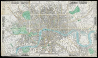
Wyld's New Plan of London.Printmaker:Wyld, James, 1812-1887 Language:EnglishFrenchGerman Region Depicted:London, England Map Type:GeographicalHistorical maps Historical Context: First edition map of London published for visitor use to London's 1851 Great Exhibition of the Works of Industry of all Nations also known as the Crystal Palace Exhibition. It was organized by Prince Albert, the consort of Queen Victoria and Sir Henry Cole who envisioned an international platform to showcase innovations in arts and technologies of the time period. The image of the Crystal Palace appears prominently in the center of the map. LC Call Number: G5754.L7 1851 W9 OCLC: 83110220 Accession Number: OML-1851-77
Itinera Varia AuctorisPrintmaker:Edwards, George Language:Latin Region Depicted:Western Europe Map Type:Geographical Dimensions: 28 x 20 cm Printing Process:Etching Historical Context: Frontspiece from the text "A natural history of uncommon birds." Undated, leaf removed from text block. Plate signed by George Edwards LC Call Number: G4720.G3 1746 E3 OCLC: 1535528372 Accession Number: OML-1746-77