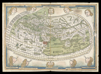
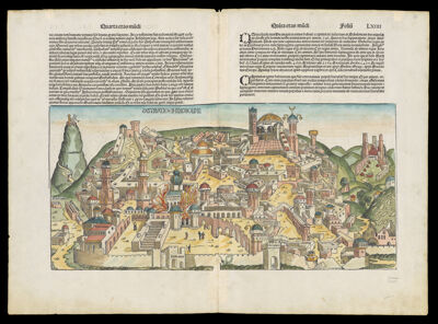
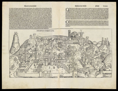
Osher Sheet Map Collection

2,392 results

[1910 state map tobacco silk New England]
Publisher:
Language:
Region Depicted:
Dimensions: 6x 4 cm on silk 8 x 5 cm
LC Call Number: G3720 1910.A4
OCLC: 1305316268
Accession Number: OS-1910-193
[1910 state map tobacco silk New England]

[Palestine]
Creator:
Atlas Reference:
Publisher:
Date/Date Range Produced: 1475
Language:
Region Depicted:
Map Type:
Dimensions: 39.2 X 57.7 cm.
Printing Process:
Material Type:
Historical Context: This 1475 map of the Holy Land is regarded as the first modern printed map because it is not derived from a classical source (Ptolemy), nor is it in the circular schematic format characteristic of medieval maps. However, it retains two attributes of earlier maps: it is oriented with east at the top, and Jerusalem is at the center. The geographic information is largely taken from a now lost manuscript map made two centuries earlier by a Dominican pilgrim, Burchard of Mt. Sion. In this bird's-eye view, topographic features are portrayed with reasonable accuracy, and cities and regions are depicted as stylized hills. Jerusalem is dominant, represented as a circular walled city overlooked by the Mount of Olives, with Bethlehem nearby on the right. Egypt and Gaza are in the lower right corner; the port of Jaffa is at the bottom center; the walled city of Acre ('Accon') is to the left of Jerusalem; and Damascus is at the upper left border. Crudely illustrated Biblical scenes include Egyptians drowning in the Red Sea (lower right), Moses receiving the Tablets of the Law on Mount Sinai (upper right corner), spires of the submerged cities of Sodom and Gomorrah protruding from the Dead Sea (upper right), the Baptism of Jesus (upper center), and the Crucifixion (below Jerusalem). Compass directions are indicated by eight 'wind-blowers' at the edges of the map.
LC Call Number: G7500 1475 .B7
OCLC: 811350004
Accession Number: OS-1475-1
Donor:
[Palestine]

Nouellae etati ad geographie viniculatos calles humano no viro necessarios flores aspirari votu bnmereti ponit
Creator:
Date/Date Range Produced: 1482
Language:
Dimensions: 13 cm. x 19 cm.
Printing Process:
Material Type:
OCLC: 856541220
Accession Number: OS-1482-2
Donor:
Nouellae etati ad geographie viniculatos calles humano no viro necessarios flores aspirari votu bnmereti ponit

The World
Creator:
Date/Date Range Produced: 1482
Language:
Dimensions: 40 x 56 cm
Printing Process:
Material Type:
LC Call Number: G3200 1482 .P7
OCLC: 743299260
Accession Number: OS-1482-3
Donor:
The World

Destrvccio Iherosolime, copy 1
Creator:
Atlas Reference:
Publisher:
Date/Date Range Produced: 1493
Language:
Region Depicted:
Map Type:
Dimensions: 26 x 54 cm., on sheet 46 x 65 cm.
Printing Process:
Material Type:
Historical Context: This dramatic woodcut synopsizes six destructions of Jerusalem and constitutes one of the earliest obtainable city views. The map shows the Temple of Solomon ablaze and attended by casually conversing onlookers. The Holy Sepulcher and Calvary are along the top. Shown to the right is Bethlehem, the birthplace of Jesus, and pictured to the left on a mountain are Satan and Christ, illustrating The Temptation.
LC Call Number: G7504.J4 70 .S3
OCLC: 811346063
Accession Number: OS-1493-2
Donor:
Destrvccio Iherosolime, copy 1

Secunda etas mundi
Creator:
Date/Date Range Produced: 1493
Language:
Dimensions: 31 x 43 cm
Printing Process:
Material Type:
LC Call Number: G3200 1493 .S3
OCLC: 743299137
Accession Number: OS-1493-3
Donor:
Secunda etas mundi

Destrvccio Iherosolime, copy 2
Creator:
Atlas Reference:
Publisher:
Date/Date Range Produced: 1493
Language:
Region Depicted:
Map Type:
Dimensions: 26 x 54 cm., on sheet 46 x 60 cm.
Printing Process:
Material Type:
Historical Context: This dramatic woodcut synopsizes six destructions of Jerusalem and constitutes one of the earliest obtainable city views. The map shows the Temple of Solomon ablaze and attended by casually conversing onlookers. The Holy Sepulcher and Calvary are along the top. Shown to the right is Bethlehem, the birthplace of Jesus, and pictured to the left on a mountain are Satan and Christ, illustrating The Temptation.
LC Call Number: G7504.J3 70 .S32
OCLC: 811346063
Accession Number: OS-1493-4
Donor:
Destrvccio Iherosolime, copy 2

[Ptolemaic Map of the World]
Creator:
Date/Date Range Produced: 1504
Language:
Dimensions: 27 cm. x 42 cm.
Printing Process:
Material Type:
OCLC: 856530477
Accession Number: OS-1504-1
Donor:
[Ptolemaic Map of the World]

World Map
Creator:
Date/Date Range Produced: 1504
Language:
Dimensions: 28 cm. x 41 cm.
Printing Process:
Material Type:
LC Call Number: G3200 1504.R4
OCLC: 214325390
Accession Number: OS-1504-2
Donor:
World Map

Ptolemaic world map
Creator:
Date/Date Range Produced: 1507
Language:
Region Depicted:
Map Type:
Dimensions: 41 x 55 cm
Printing Process:
Material Type:
LC Call Number: G3200 1507 .P72
OCLC: 743299316
Accession Number: OS-1507-1
Donor:
Ptolemaic world map