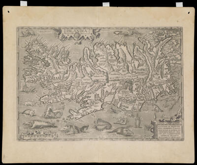
Osher Sheet Map Collection

2,393 results

Hispaniae Novae Sivae Magnae, Recens et Vera Descriptio. 1579., copy 2
Creator:
Atlas Reference:
Date/Date Range Produced: 1579
Language:
Region Depicted:
Map Type:
Dimensions: 35 x 50 cm. on sheet 45 x 53 cm.
Printing Process:
Material Type:
LC Call Number: G4410 1601 O72
OCLC: 701830636
Accession Number: OS-1601-3
Donor:
Hispaniae Novae Sivae Magnae, Recens et Vera Descriptio. 1579., copy 2

Islandia
Creator:
Atlas Reference:
Dedicatee:
Publisher:
Date/Date Range Produced: 1585
Language:
Region Depicted:
Map Type:
Dimensions: 34 x 49 cm. on sheet 46 x 56 cm.
Printing Process:
Material Type:
Historical Context: This is one of the more spectacular maps in the Ortelius atlas, with its vivid depiction of the rugged terrain of Iceland including fiords, mountain ranges, glaciers, and the erupting Hekla volcano. Its most engaging feature, however, is the collection of fantastic sea monsters inhabiting the surrounding waters. Some of them are based on faulty observation or inaccurate descriptions of real creatures such as whales. It is likely that the majority derived from medieval legends, mariners' tales, or outright artistic license. As testimony to their purported authenticity, each of the creatures is assigned an identifying letter keyed to a detailed description on the back of the map.
LC Call Number: G6930 1602 .O7
OCLC: 830863041
Accession Number: OS-1602-1
Donor:
Islandia

Americae Novissima Descriptio 1589
Creator:
Date/Date Range Produced: 1602
Language:
Dimensions: 33 x 49 cm.
Printing Process:
Material Type:
LC Call Number: G3290 1602 .H6
OCLC: 819759721
Accession Number: OS-1602-3
Donor:
Subjects:
Americae Novissima Descriptio 1589

Orbis Terrae Novissima Descriptio
Creator:
Date/Date Range Produced: 1602
Language:
Region Depicted:
Dimensions: H 37.2 x W 51.8 cm
Printing Process:
Material Type:
LC Call Number: G3200 1602 .L4
OCLC: 60357385
Accession Number: OS-1602-4
Donor:
Orbis Terrae Novissima Descriptio

Vera Hierosolymae Veteris Imago a Ioanne Baptista Villalpando Cordvbensi e Societate Iesv Elaborata Pro Svo Vrbis ac Templi Hierosolymitani Apparatv Collato Stvdio Cvm P. Hieronymo Prado Ex Eadem Societate Romae Superiorum permissu cum Priuilegio Summi Pontificus Imperatoris Regis Catholici ac Senatus Veneti
Creator:
Date/Date Range Produced: 1604
Language:
Region Depicted:
Map Type:
Dimensions: H 72 x W 78 cm
Printing Process:
Material Type:
Historical Context: Villalpando was a Jesuit architect and scholar whose imaginary map of ancient Jerusalem was based on Biblical accounts. In the belief that Solomon's Temple was the symbol of the heavenly Jerusalem to come, Villalpando created a detailed pictorial reconstruction and plan of the Temple patterned after the prophet Ezekiel's visionary description. A miniature version of his plan appears at the bottom center of the map. Several other Biblical sites are depicted within the city, including a circular City of David (upper left). Roman encampments and Biblical monuments are seen outside the walls. Villalpando's scholarship was widely respected and his conceptions of Solomon's Temple and ancient Jerusalem were accepted and copied for more than a century.
Accession Number: OS-1604-1
Donor:
Subjects:
Vera Hierosolymae Veteris Imago a Ioanne Baptista Villalpando Cordvbensi e Societate Iesv Elaborata Pro Svo Vrbis ac Templi Hierosolymitani Apparatv Collato Stvdio Cvm P. Hieronymo Prado Ex Eadem Societate Romae Superiorum permissu cum Priuilegio Summi Pontificus Imperatoris Regis Catholici ac Senatus Veneti

Totius Orbis Cogniti Universalis Descriptio.
Creator:
Date/Date Range Produced: 1605
Language:
Dimensions: H 32.9 x W 50.5 cm
Printing Process:
Material Type:
LC Call Number: G3200 1605 .M4
OCLC: 819758102
Accession Number: OS-1605-2
Donor:
Totius Orbis Cogniti Universalis Descriptio.

Abrahami Patriarchae Peregrinatio, et Vita. Abrahamo Ortelio Antverpiano auctore.
Creator:
Atlas Reference:
Dedicatee:
Publisher:
Date/Date Range Produced: 1586
Language:
Region Depicted:
Map Type:
Dimensions: H 39 x W 50 cm
Printing Process:
Material Type:
Historical Context: This map is an acknowledged masterpiece of composition and engraving by the great Flemish cartographer, Abraham Ortelius; it illustrates the Biblical story of Abraham the Patriarch as recorded in Genesis. The Hebrew peoples were originally nomadic. Their origins lie with the Patriarch Abraham and his migration from Mesopotamia to the Promised Land of Canaan, where his followers and descendants settled. The decorative border contains twenty-two medallions portraying scenes from the life of Abraham, such as the sacrifice of Isaac. The central portion is in the form of a tapestry containing two maps. The small inset map at upper left traces Abraham's wanderings from Ur in the Euphrates Valley to the Promised Land of Canaan; several cities are named, the most prominent of which is Salem, the future Jerusalem. The larger map depicts the ancient tribal divisions of the Land of Canaan as described in Genesis; the largest city, as judged by its symbolic representation, is named "Salem, et Ierusalem."
LC Call Number: G7481.2 1608 .O7
OCLC: 819752711
Accession Number: OS-1608-2
Donor:
Abrahami Patriarchae Peregrinatio, et Vita. Abrahamo Ortelio Antverpiano auctore.