Continuing warfare between the British, French, and indigenous populations severely weakened the Wabanaki to the point where they could no longer resist the region’s colonization. They progressively surrendered land in return for trade concessions as the English kept pushing along the coast and up the major valleys. English encroachment from the south intensified when New France fell in 1759 and removed the threat of French support for the Wabanaki.
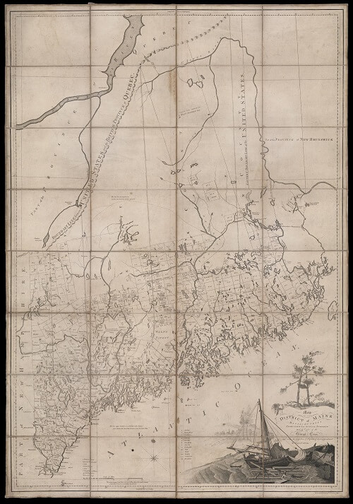
The Massachusetts Bay authorities understood and arranged the new settlement in an apparently neat territorial hierarchy, shown in the map made by John Small in 1761 for the governor, Sir Francis Bernard [item 6]. English settlement was organized in towns, shown by Small in red, that were allotted either by large land holders (such as the so-called Kennebec Proprietors) or directly by the provincial authorities. The towns were grouped by three administrative counties: the original county of York from which Cumberland and Lincoln counties were formed in 1760. Each country was defined as a stretch of coast between major rivers with an abstract, interior extension.
In reality, there were plenty of people who lived outside of this neat hierarchy, especially French settlers in the north, recent Irish immigrants, and of course the Wabanaki themselves (shown with clumps of triangles). English settlement required the prior agreement of local Wabanaki when they were able to assert their authority. On the ground, colonial settlement entailed extensive negotiations. On the map, the tool by which the English organized and comprehended the land, the Wabanaki were intentionally mapped out.
In 1775, Massachusetts Bay authorities resolved, in return for the Penobscots’ loyalty during the Revolution, to forbid trespassing on Penobscot lands within a band, six miles to either side of the Penobscot River, beginning at the head of the tide. However, the new Commonwealth of Massachusetts soon asserted that the Penobscot had implicitly agreed that their lands comprised only that band along the river. So began a rapid process that pushed the Penobscot from their land and opened it up to American settlement.
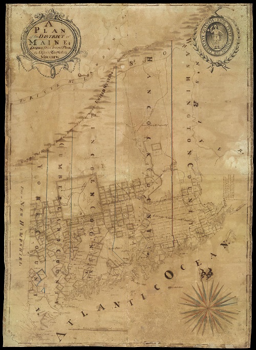
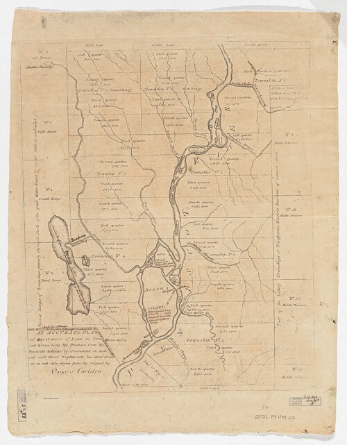
Maps by the Boston surveyor Osgood Carleton show this process as it happened. Carleton’s 1795 manuscript map [7], made for the Commonwealth’s Committee on Eastern Lands, shows how only vaguely delimited “Indian Lands” along the river were already being eaten away by new towns on the west bank above the confluence of the Piscataquis. Under the 1796 treaty, the Penobscot retained the islands in the river, but were forced to cede all land below the Piscataquis; the ceded land was quickly laid out for sale to settlers [8]. Carleton’s 1798 and 1802 maps, both made for the Commonwealth [9, 10], remain vague about the limits of Penobscot land, even as “Mast Townships” start to encroach. Eventually, the Penobscot were limited just to the east branch [11] and then, after an 1818 treaty, to just four towns [12], which would themselves be claimed by the State of Maine in 1833, leaving the Penobscot only their river islands.
6
John Small
“…this map of the County’s of York Cumberland & Lincoln taken from the best authorities” (10 April 1761), prepared for Sir Francis Bernard.
Manuscript in four sheets, each sheet 39 × 48–50 cm
Osher Collection
https://oshermaps.org/map/42889.0001
https://oshermaps.org/map/42890.0001
https://oshermaps.org/map/42891.0001
https://oshermaps.org/map/42892.0001

7
Osgood Carleton
“A Plan of the District of Maine; Drawn from Several Plans” (1795).
Manuscript in four sheets, 146 × 103 cm
Osher Collection
https://oshermaps.org/map/896.0001
8
Osgood Carleton
An Accurate plan of 189,120 Acres of Land on Penobscot River being the Purchase from the Penobscot Indians by Government on Each Side [of] Said River together with Two Gores of Land, One on Each Side ([Boston], [1798]).
Copper engraving, 49 × 40 cm
Harvard Map Collection
Harvard University, Cambridge, Mass.
9
Osgood Carleton
An Accurate Map of the District of Maine, Being Part of the Commonwealth of Massachusetts, Compiled Pursuant to an Act of the General Court (Boston, 1798).
Copper engraving in four sheets, 138 × 98 cm
Osher Collection
https://oshermaps.org/map/901.0001

10
Osgood Carleton
Map of the District of Maine, Massachusetts, Compiled from Actual Surveys Made by Order of the General Court (Boston, [1802]).
Copper engraving in four sheets, dissected and mounted on cloth, 135 × 93 cm
Osher Collection
https://oshermaps.org/map/2600.0001