The “towns” into which the English and Americans subdivided the lands of the Wabanaki in Maine were not, of course, built-up places. They were areas of land over which colonists settled in dispersed farms. Some proprietors encouraged the formation, although with mixed success, of more focused or “nucleated” villages; other villages developed in a more organic manner. Flourishing villages variously provided: a shared pool of labor, as in the original Wabanaki villages; commercial services at a central location within a region, and also civic services, from Alfred’s county courthouse [26 in §3b] to Augusta’s state government [29]; safe sites for the transshipment of goods from one mode of transportation to another, which is to say the ports in early Maine, notably Portland [28, 30] and Bangor; and access to raw materials and the power needed for industry, which in Maine meant the hydropower offered by waterfalls and dams that destroyed the Wabanakis’ prime fishing sites [27, 29].
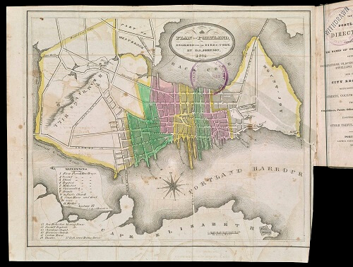
Even when Maine’s urban centers remained small, their boosters adopted the trappings of urban status. While still “walking cities”—in which residents still knew each other and it was easy for strangers to ask directions to get around—Portland and Bangor acquired printed directories with maps intended more to show off the city rather than to aid mobility [27, 28]; notably, the early city directories tended to list non-White residents in separate appendices. And ever more ornate maps and views of were published, for residents to display on walls in their homes and their businesses and so show their civic pride [29, 30]. This process continued into the twentieth century, leaving a vibrant printed record of urban growth.
27
A Plan of the City of Bangor…1834, engr. Pendleton’s Lithography, Boston, in The Bangor Directory (Bangor: James Burton, Jr., 1834).
Hand-colored lithograph, 27 × 53.5 cm
OML Collections
https://oshermaps.org/map/53995.0038

28
A Plan of Portland, engr. D. G. Johnson, in The Portland Directory (Portland: Arthur Shirley, 1834).
Hand-colored copper engraving, 23.5 × 28 cm
OML Collections
https://oshermaps.org/map/7310.0001
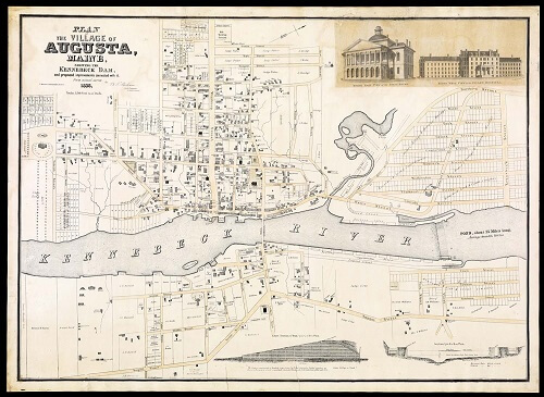
29
Benjamin Franklin Perham
Plan of the Village of Augusta Maine, Shewing the Kennebeck Dam, and Proposed Improvements Connected with It. From Actual Survey…
(Boston: T. Moore’s Lithography, 1838).
Hand-colored lithograph, 70 × 96 cm
Osher Collection
https://oshermaps.org/map/37548.0001
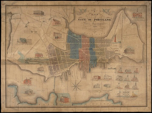
30
John Cullum
A Map of the City of Portland, with the Latest Improvements. Including a View of the Principal Buildings (Portland, 1836).
Hand-colored copper engraving, 55 × 74.5 cm
OML Collections
https://oshermaps.org/map/11753.0001