The Commonwealth of Massachusetts used a lottery to raise money to pay off debts from the Revolutionary War: buy a ticket and perhaps win land. Given that the lottery lands lay in Hancock and Washington counties without easy access to the coast or to the Penobscot or the St. Croix rivers [21], the lottery failed and the lands were eventually acquired by the Philadelphia speculator William Bingham.
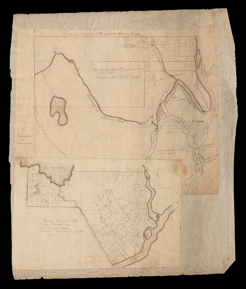
Individual towns were created atop Wabanaki lands. A copy of Samuel Western’s 1790 plan of the towns of Madison and Cornville (North is to the left), just north of Norridgewock [22], and a plan of Orono on the Penobscot, from 1818 [23], both record several Wabanaki placenames for reference.
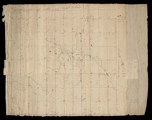
Proprietors could only recoup their investment in buying a town by selling or renting the land, and revenue depended on land quality. Detailed assessments were sometimes made of the quality of timber (pine, hardwood, etc.) and land (swamp, etc.) by running transects through an unidentified town [24]. Such maps are rare and they allow us to understand early environmental conditions.
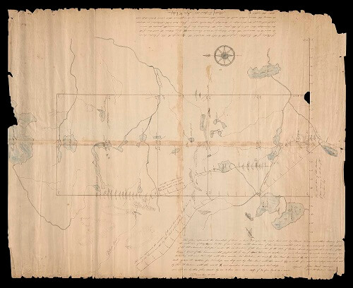
Good access increased the value of interior lands, whether by river or land. When new roads were built, such as those to Canada by Charles Turner, Jr., in about 1810, new towns followed [25]. The easterly road is now followed roughly by US-201 through Jackman (town 1).
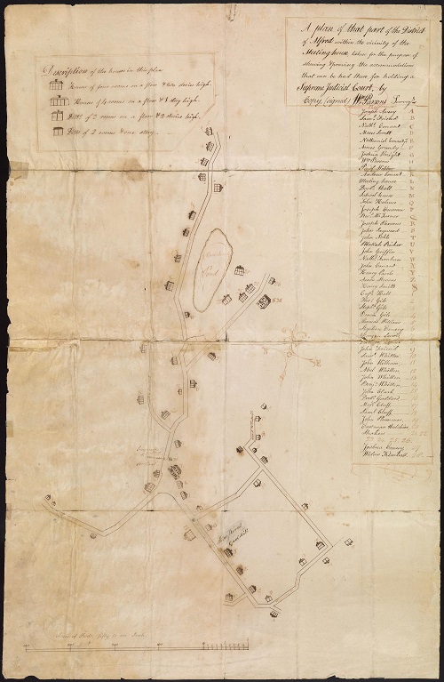
As population increased, urban centers began to form. In southern Maine, Alfred successfully argued that it should be host to the York County court, to better serve the interior settlers. The remarkable plan from 1811 maps out the number of beds around the village that could put up all the lawyers and witnesses for the periodic assizes [26].
21
Plan of 50 Townships to Be Sold by Lottery Lying between the Rivers Penobscot & Schoodic (Boston: Commonwealth of Massachusetts, [1786]).
Hand-colored copper engraving, with manuscript annotations, 34 × 45 cm
OML Collections, Gift of Harry Pringle in honor of Peggy Osher
https://oshermaps.org/map/45937.0001

22
“The above plan discribes two townships of land in the County of Lincoln on the east side of Kennebeck River,” after Samuel Weston (2 February 1791).
Manuscript, 32.5 × 39.5 cm
OML Collections
https://oshermaps.org/map/51522.0001

23
“Plan of Township No. 5 West of Penobscot River, now a part of Orono,” after Andrew Strong (after 1818).
Manuscript, 46 × 39 cm
OML Collections
https://oshermaps.org/map/53385.0001
Map Commentary by James E. Francis, Sr., Penobscot Tribal Historian and Director of Cultural and Historic Preservation
How do we interpret Place? Cultural Geographer Yi Fu Tuan formulated that SPACE plus Culture equals PLACE. This seemingly easy formula gives us the tools to transpose, or re-transpose, one CULTURE in a SPACE for another. By doing this we change the outcome; we change the sense of PLACE. On this map, let’s explore a Penobscot Sense of Place.
At the lower end of the map there is an island labeled Southgate Island. This was named for a landowner named John Southgate. The Penobscot name for this island meant “Ant Hill Island.” According to Penobscot ancestor Clara Neptune, this island was a place to keep caches. The ease of digging allowed storage pits to be dug. This island was also known for its channel.
In the Penobscot River, there are many names for the river. In indigenous nomenclature the river is divided up into sections, these sections denoting the character of the river with local context. The river just below “Ant Hill Island,” is translated to “where the river creates a channel,” and thereby placing importance on the channel. It is important to note that from this place, the churning waters of the upcoming falls can be seen and heard, making the channel inviting.
The channel flows to the west of the island and leads to an overland carry. This portage cuts across the peninsula into the branch of the river coming from the west, just above the great falls tumbling down into the main stem. This branch is known as the “Stillwater,” or “Dead (flat) water.” This name is significant, as it is the easier way to go. The portage bi-passes the falls on the main stem, as well as the falls at the terminus of the Stillwater Branch. This maneuver changes the course of the traveler, it requires up river travel on the branch rather than the main stem. As the name suggests it requires up river travel on flat water. The main stem from this point north contains many obstacles such as “slippery ledge falls,” “Bad Falls at the site of a bad portage,” and the substantial Penobscot Falls. By taking the Stillwater Branch travelers only had to negotiate the “Short easy carry,” at Jamison Falls, to get above the Penobscot Falls.
It is interesting to note that in recent years, after the removal of dams, Penobscot people have found petroglyphs at each end of canoe route and portage, permanent makers for the travelers.
24
Untitled plan of a township, showing timber survey
(ca. 1825).
Manuscript, 52 × 60 cm.
OML Collections
https://oshermaps.org/map/53387.0001
25
John Neal and Thomas McKechnie, “This plan represents ten townships of land as laid out upon the road laid out by Charles Turner and others, leading from the north line of Bingham’s million of acres to the north boundary of this Commonwealth” (30 December 1811).
Manuscript, 76 × 61.5 cm
OML Collections
https://oshermaps.org/map/53450.0001
26
William Parsons, “A plan of that part of the District of Alfred within the vicinity of the Meetinghouse, taken for the purpose of shewing & proving the accommodations that can be had there for holding a Supreme Judicial Court” (1811).
Manuscript, 77 × 49.5 cm
Osher Collection
https://oshermaps.org/map/934.0001