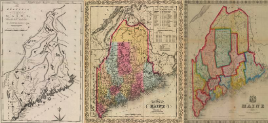

The most persistent atlas map of antebellum Maine was A New Map of Maine, which appeared in twenty-eight variants between 1833 and 1860: a remarkable number. Henry Schenck Tanner, a prominent Philadelphia map publisher, created it for his [New] Universal Atlas (published in sections from 1833, then as a single work from 1836) [map 18]. A variety of other Philadelphia publishers issued the atlas after 1842. In 1846, S. Augustus Mitchell took Tanner’s name off the map and added his own, during a failed experiment in color printing [24, in the central floor case]. Further issues of the map continued to appear with updated content and bearing various publishers’ names [19-23].
Henry S. Tanner
A New Map of Maine
From Henry S. Tanner, Tanner’s Universal Atlas (Philadelphia, 1833)
Engraving, hand-colored; 36cm x 28.5cm
Thompson, no. 70 — State I
S. Augustus Mitchell
A New Map of Maine
From S. Augustus Mitchell, A New Universal Atlas (Philadelphia, 1846)
Lithograph, hand-colored; 38.5cm x 30.5cm
Thompson, no. 83 — State XI
Henry S. Tanner
A New Map of Maine
Philadelphia, 1845
Lithograph, hand-colored; 37cm x 29cm, folding to 11.5cm x 7cm
S. Augustus Mitchell
A New Map of Maine
From S. Augustus Mitchell, A New Universal Atlas (Philadelphia, 1854)
Lithograph, hand-colored; 38.5cm x 30.5cm
Thompson, no. 93 — State XXI
Charles Desilver
A New Map of Maine
From [S. Augustus Mitchell], A New Universal Atlas (Philadelphia: Charles Desilver, 1857)
Lithograph, hand-colored; 35.5cm x 28cm
Thompson, no. 95 — State XXIII
S. Augustus Mitchell
A New Map of Maine
Philadelphia: Thomas, Cowperthwaite & Co., 1852
Lithograph, hand-colored; 38cm x 30.5cm, folding to 11.5cm x 7.5cm
Thompson, no. 92 — State XX
S. Augustus Mitchell
A New Map of Maine
In S. Augustus Mitchell, Maps of Maine, New Hampshire and Vermont, Massachusetts & Rhode Island, Connecticut, New York, and New York City (Philadelphia, 1846)
Lithograph, printed color; 40cm x 32cm
Thompson, no. 79 — State IX